Nayemont-les-Fosses (Nayemont-les-Fosses)

- commune in Vosges, France
- Country:

- Postal Code: 88100
- Coordinates: 48° 17' 48" N, 7° 0' 22" E


- GPS tracks (wikiloc): [Link]
- Area: 8.91 sq km
- Population: 829
- Web site: http://nayemontlesfosses.free.fr
- Wikipedia en: wiki(en)
- Wikipedia: wiki(fr)
- Wikidata storage: Wikidata: Q927028
- Wikipedia Commons Category: [Link]
- Freebase ID: [/m/03qgv_4]
- Freebase ID: [/m/03qgv_4]
- GeoNames ID: Alt: [6445661]
- GeoNames ID: Alt: [6445661]
- SIREN number: [218803203]
- SIREN number: [218803203]
- BnF ID: [15279246p]
- BnF ID: [15279246p]
- INSEE municipality code: 88320
- INSEE municipality code: 88320
Shares border with regions:

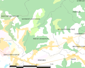
Pair-et-Grandrupt
- commune in Vosges, France
- Country:
- Postal Code: 88100
- Coordinates: 48° 16' 52" N, 7° 1' 7" E
- GPS tracks (wikiloc): [Link]
- AboveSeaLevel: 388 м m
- Area: 4.58 sq km
- Population: 527
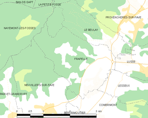
Frapelle
- commune in Vosges, France
- Country:
- Postal Code: 88490
- Coordinates: 48° 17' 39" N, 7° 3' 50" E
- GPS tracks (wikiloc): [Link]
- AboveSeaLevel: 462 м m
- Area: 4.55 sq km
- Population: 198


Neuvillers-sur-Fave
- commune in Vosges, France
- Country:
- Postal Code: 88100
- Coordinates: 48° 16' 42" N, 7° 2' 15" E
- GPS tracks (wikiloc): [Link]
- Area: 5.12 sq km
- Population: 343
- Web site: [Link]


La Petite-Fosse
- commune in Vosges, France
- Country:
- Postal Code: 88490
- Coordinates: 48° 19' 14" N, 7° 3' 12" E
- GPS tracks (wikiloc): [Link]
- AboveSeaLevel: 440 м m
- Area: 5.04 sq km
- Population: 82

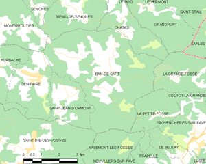
Ban-de-Sapt
- commune in Vosges, France
- Country:
- Postal Code: 88210
- Coordinates: 48° 20' 34" N, 7° 0' 50" E
- GPS tracks (wikiloc): [Link]
- AboveSeaLevel: 550 м m
- Area: 22.66 sq km
- Population: 351


Sainte-Marguerite
- commune in Vosges, France
- Country:
- Postal Code: 88100
- Coordinates: 48° 16' 9" N, 6° 58' 35" E
- GPS tracks (wikiloc): [Link]
- AboveSeaLevel: 360 м m
- Area: 5.55 sq km
- Population: 2346
- Web site: [Link]

Saint-Dié-des-Vosges
- commune in Vosges, France
- Country:
- Postal Code: 88100
- Coordinates: 48° 17' 3" N, 6° 56' 57" E
- GPS tracks (wikiloc): [Link]
- AboveSeaLevel: 343 м m
- Area: 46.15 sq km
- Population: 20079
- Web site: [Link]