Sainte-Marguerite (Sainte-Marguerite)

- commune in Vosges, France
- Country:

- Postal Code: 88100
- Coordinates: 48° 16' 9" N, 6° 58' 35" E


- GPS tracks (wikiloc): [Link]
- AboveSeaLevel: 360 м m
- Area: 5.55 sq km
- Population: 2346
- Web site: http://www.ville-saintemarguerite.fr
- Wikipedia en: wiki(en)
- Wikipedia: wiki(fr)
- Wikidata storage: Wikidata: Q337804
- Wikipedia Commons Category: [Link]
- Freebase ID: [/m/03qgy69]
- Freebase ID: [/m/03qgy69]
- GeoNames ID: Alt: [6617905]
- GeoNames ID: Alt: [6617905]
- SIREN number: [218804243]
- SIREN number: [218804243]
- BnF ID: [15279343x]
- BnF ID: [15279343x]
- INSEE municipality code: 88424
- INSEE municipality code: 88424
Shares border with regions:

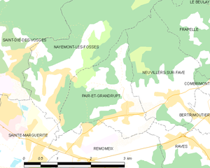
Pair-et-Grandrupt
- commune in Vosges, France
- Country:
- Postal Code: 88100
- Coordinates: 48° 16' 52" N, 7° 1' 7" E
- GPS tracks (wikiloc): [Link]
- AboveSeaLevel: 388 м m
- Area: 4.58 sq km
- Population: 527


Saulcy-sur-Meurthe
- commune in Vosges, France
- Country:
- Postal Code: 88580
- Coordinates: 48° 14' 11" N, 6° 57' 35" E
- GPS tracks (wikiloc): [Link]
- Area: 16.37 sq km
- Population: 2339
- Web site: [Link]


Entre-deux-Eaux
- commune in Vosges, France
- Country:
- Postal Code: 88650
- Coordinates: 48° 13' 53" N, 6° 59' 31" E
- GPS tracks (wikiloc): [Link]
- Area: 8.47 sq km
- Population: 516

Saint-Dié-des-Vosges
- commune in Vosges, France
- Country:
- Postal Code: 88100
- Coordinates: 48° 17' 3" N, 6° 56' 57" E
- GPS tracks (wikiloc): [Link]
- AboveSeaLevel: 343 м m
- Area: 46.15 sq km
- Population: 20079
- Web site: [Link]


Remomeix
- commune in Vosges, France
- Country:
- Postal Code: 88100
- Coordinates: 48° 16' 8" N, 7° 0' 4" E
- GPS tracks (wikiloc): [Link]
- Area: 4.73 sq km
- Population: 480
- Web site: [Link]


Nayemont-les-Fosses
- commune in Vosges, France
- Country:
- Postal Code: 88100
- Coordinates: 48° 17' 48" N, 7° 0' 22" E
- GPS tracks (wikiloc): [Link]
- Area: 8.91 sq km
- Population: 829
- Web site: [Link]