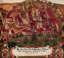
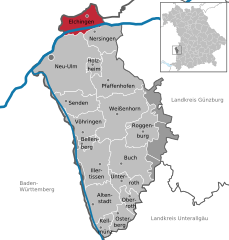
Nersingen (Nersingen)

- municipality of Germany
 Hiking in Nersingen
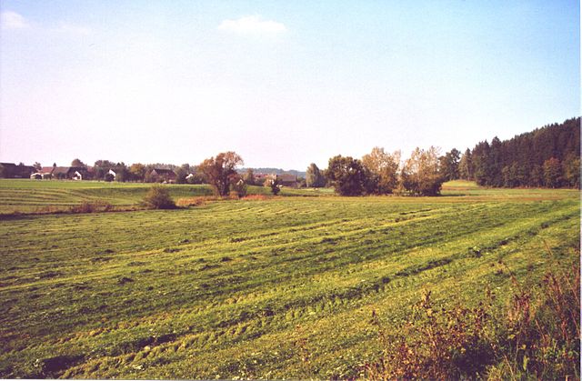
Nersingen is located in Bavaria, Germany, and is known for its beautiful landscapes and picturesque nature, making it a lovely spot for hiking enthusiasts. While there aren't extensive hiking trails specifically designated in Nersingen, you can find routes that connect to the surrounding areas, which offer a variety of hiking options.
Hiking Options:
-
Nearby Nature Reserves and Parks:
- Explore the nearby nature reserves and parks, such as the Donauried, which is a wetland area teeming with wildlife and various natural trails.
-
Scenic Routes:
- You can take scenic routes that lead you through lush meadows, forests, and along the banks of the Danube River. The region is characterized by gently rolling hills and beautiful farmland, offering a peaceful hiking experience.
-
Local Trails:
- Check local maps and resources for specific trails in and around Nersingen. Many local hiking clubs provide maps and suggested hiking routes that can guide you through the most scenic parts of the area.
-
Access to Larger Trails:
- Nersingen is relatively close to larger hiking paths, such as parts of the Bavarian Jura or routes leading towards Ulm, which offer more extensive and structured trails for various skill levels.
Tips for Hiking in Nersingen:
- Weather: Always check the local weather before heading out, as conditions can change.
- Safety: Familiarize yourself with the trail difficulty and ensure you have appropriate gear.
- Wildlife: Be aware of local wildlife and heed any guidelines regarding safety or conservation.
- Maps and Guides: Carry a local hiking map and inform someone about your hiking plans, especially if venturing onto lesser-known trails.
Conclusion:
Hiking in and around Nersingen can provide a serene escape into nature, showcasing the Bavarian landscape's beauty. Exploring local trails, enjoying the flora and fauna, and experiencing the tranquility of this region can make for an enjoyable outdoor adventure.
- Country:

- Postal Code: 89278
- Local Dialing Code: 07308
- Licence Plate Code: ILL; NU
- Coordinates: 48° 25' 44" N, 10° 7' 19" E


- GPS tracks (wikiloc): [Link]
- AboveSeaLevel: 465 м m
- Area: 24.28 sq km
- Population: 9437
- Web site: https://www.nersingen.de/
- Wikipedia en: wiki(en)
- Wikipedia: wiki(de)
- Wikidata storage: Wikidata: Q514223
- Wikipedia Commons Category: [Link]
- Freebase ID: [/m/071078]
- GeoNames ID: Alt: [2866473]
- BnF ID: [120822511]
- VIAF ID: Alt: [127962436]
- OSM relation ID: [941074]
- GND ID: Alt: [4041630-6]
- Library of Congress authority ID: Alt: [n89146591]
- Historical Gazetteer (GOV) ID: [NERGE1JN58BK]
- Bavarikon ID: [ODB_A00000692]
- Pleiades ID: [118867]
- German municipality key: 09775134
Includes regions:
Straß
- human settlement in Germany
Hiking in Straß
Hiking around Straß in Nersingen, Germany, offers scenic views, peaceful trails, and a great opportunity to enjoy the natural beauty of the region. Here are some highlights and tips for hiking in this area:...
- Country:
- Postal Code: 89278
- Local Dialing Code: 07308
- Coordinates: 48° 24' 51" N, 10° 8' 12" E
- GPS tracks (wikiloc): [Link]
- AboveSeaLevel: 467 м m
Leibi
- suburb of Nersingen, Bavaria, Germany
Hiking in Leibi
Leibi, located in Nersingen, Germany, is part of the picturesque landscapes of the Swabian Jura. While it may not be as widely known as some major hiking destinations, it offers delightful opportunities for outdoor enthusiasts who appreciate natural beauty and tranquil surroundings....
- Country:
- Postal Code: 89278
- Local Dialing Code: 07308
- Coordinates: 48° 25' 57" N, 10° 6' 37" E
- GPS tracks (wikiloc): [Link]
- AboveSeaLevel: 460 м m
Oberfahlheim
- suburb of Nersingen, Bavaria, Germany
Hiking in Oberfahlheim
Oberfahlheim is a charming village located in Germany, known for its picturesque landscapes and access to hiking routes. While specific trails in Oberfahlheim might not be widely documented, the surrounding region often offers a great variety of hiking opportunities....
- Country:
- Postal Code: 89278
- Local Dialing Code: 07308
- Coordinates: 48° 25' 45" N, 10° 8' 42" E
- GPS tracks (wikiloc): [Link]
Unterfahlheim
- suburb of Nersingen, Bavaria, Germany
Hiking in Unterfahlheim
Unterfahlheim is a small village located in Bavaria, Germany. While it may not be as well-known for hiking as some of the larger mountainous regions, it offers beautiful scenic areas typical of the Bavarian countryside that can provide a pleasant hiking experience....
- Country:
- Postal Code: 89278
- Local Dialing Code: 07308
- Coordinates: 48° 25' 52" N, 10° 9' 42" E
- GPS tracks (wikiloc): [Link]
Shares border with regions:


Bibertal
- municipality of Germany
Hiking in Bibertal
Bibertal is a beautiful region in Bavaria, Germany, known for its picturesque landscapes and variety of hiking trails. Here are some key points to consider when planning a hiking trip in this area:...
- Country:
- Postal Code: 89346
- Local Dialing Code: 08226
- Licence Plate Code: GZ
- Coordinates: 48° 24' 0" N, 10° 12' 0" E
- GPS tracks (wikiloc): [Link]
- AboveSeaLevel: 495 м m
- Area: 27.31 sq km
- Population: 4021
- Web site: [Link]


Neu-Ulm
- town in Bavaria, Germany
Hiking in Neu-Ulm
Neu-Ulm, located in Bavaria, Germany, sits along the banks of the Danube River and offers a variety of hiking opportunities in the surrounding areas. While the city itself is more urban, the nearby countryside and natural landscapes provide excellent options for outdoor exploration. Here are a few highlights related to hiking in and around Neu-Ulm:...
- Country:
- Postal Code: 89231
- Local Dialing Code: 0731; 07308; 07307
- Licence Plate Code: NU
- Coordinates: 48° 23' 0" N, 10° 0' 0" E
- GPS tracks (wikiloc): [Link]
- AboveSeaLevel: 474 м m
- Area: 80.50 sq km
- Population: 57727
- Web site: [Link]
Elchingen
- municipality of Germany
Hiking in Elchingen
Elchingen, located in Bavaria, Germany, is a charming area known for its picturesque landscapes and outdoor activities, including hiking. The region is characterized by its rolling hills, lush forests, and scenic rivers, making it an attractive destination for nature enthusiasts....
- Country:
- Postal Code: 89081; 89275
- Local Dialing Code: 0731; 07308
- Licence Plate Code: ILL; NU
- Coordinates: 48° 27' 6" N, 10° 5' 52" E
- GPS tracks (wikiloc): [Link]
- AboveSeaLevel: 465 м m
- Area: 24.87 sq km
- Population: 9341
- Web site: [Link]


Leipheim
- municipality of Germany
Hiking in Leipheim
Leipheim, located in Bavaria, Germany, offers some pleasant hiking opportunities in and around the area. While it may not be as renowned as other hiking destinations in the Alps or more mountainous regions, it serves as a great base for exploring the surrounding landscapes....
- Country:
- Postal Code: 89340
- Local Dialing Code: 08221
- Licence Plate Code: GZ
- Coordinates: 48° 27' 0" N, 10° 13' 22" E
- GPS tracks (wikiloc): [Link]
- AboveSeaLevel: 471 м m
- Area: 32.15 sq km
- Population: 5132
- Web site: [Link]

Pfaffenhofen an der Roth
- municipality of Germany
Hiking in Pfaffenhofen an der Roth
Pfaffenhofen an der Roth, located in Bavaria, Germany, is surrounded by beautiful landscapes that make it an excellent spot for hiking enthusiasts. The region features a mix of forested pathways, rolling hills, and picturesque rural settings, ideal for hikers of all levels....
- Country:
- Postal Code: 89284
- Local Dialing Code: 07302
- Licence Plate Code: ILL; NU
- Coordinates: 48° 21' 16" N, 10° 9' 43" E
- GPS tracks (wikiloc): [Link]
- AboveSeaLevel: 489 м m
- Area: 42.66 sq km
- Population: 5897
- Web site: [Link]