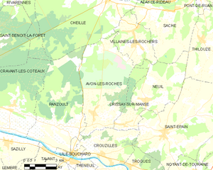
Neuil (Neuil)

- commune in Indre-et-Loire, France
- Country:

- Postal Code: 37190
- Coordinates: 47° 10' 17" N, 0° 30' 45" E


- GPS tracks (wikiloc): [Link]
- Area: 18.82 sq km
- Population: 436
- Web site: http://www.mairie-neuil.fr/
- Wikipedia en: wiki(en)
- Wikipedia: wiki(fr)
- Wikidata storage: Wikidata: Q1142182
- Wikipedia Commons Category: [Link]
- Freebase ID: [/m/03nvfxm]
- GeoNames ID: Alt: [6433065]
- SIREN number: [213701659]
- BnF ID: [152577167]
- INSEE municipality code: 37165
Shares border with regions:

Avon-les-Roches
- commune in Indre-et-Loire, France
- Country:
- Postal Code: 37220
- Coordinates: 47° 9' 24" N, 0° 26' 55" E
- GPS tracks (wikiloc): [Link]
- Area: 33.28 sq km
- Population: 553
- Web site: [Link]

Thilouze
- commune in Indre-et-Loire, France
- Country:
- Postal Code: 37260
- Coordinates: 47° 13' 23" N, 0° 34' 49" E
- GPS tracks (wikiloc): [Link]
- Area: 33.75 sq km
- Population: 1661
- Web site: [Link]


Villaines-les-Rochers
- commune in Indre-et-Loire, France
- Country:
- Postal Code: 37190
- Coordinates: 47° 13' 16" N, 0° 29' 49" E
- GPS tracks (wikiloc): [Link]
- Area: 12.47 sq km
- Population: 1056


Saché
- commune in Indre-et-Loire, France
- Country:
- Postal Code: 37190
- Coordinates: 47° 14' 49" N, 0° 32' 35" E
- GPS tracks (wikiloc): [Link]
- Area: 28.29 sq km
- Population: 1377
- Web site: [Link]


Crissay-sur-Manse
- commune in Indre-et-Loire, France
- Country:
- Postal Code: 37220
- Coordinates: 47° 9' 1" N, 0° 29' 16" E
- GPS tracks (wikiloc): [Link]
- Area: 7.5 sq km
- Population: 97
- Web site: [Link]


Saint-Épain
- commune in Indre-et-Loire, France
- Country:
- Postal Code: 37800
- Coordinates: 47° 8' 43" N, 0° 32' 13" E
- GPS tracks (wikiloc): [Link]
- Area: 62.65 sq km
- Population: 1563
- Web site: [Link]