canton of Sainte-Maure-de-Touraine (canton de Sainte-Maure-de-Touraine)

- canton of France
- Country:

- Capital: Sainte-Maure-de-Touraine
- Coordinates: 47° 5' 40" N, 0° 36' 14" E


- GPS tracks (wikiloc): [Link]
- Population: 27416
- Wikipedia en: wiki(en)
- Wikipedia: wiki(fr)
- Wikidata storage: Wikidata: Q212369
- INSEE canton code: [3713]
Includes regions:
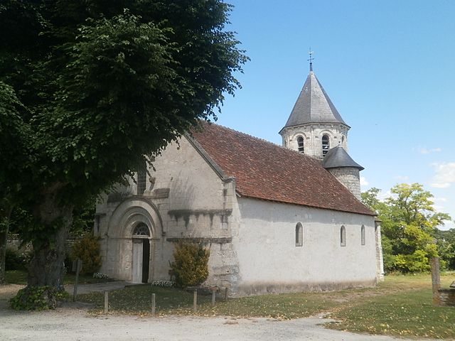
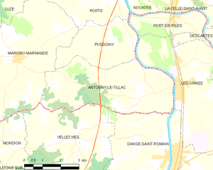
Antogny-le-Tillac
- commune in Indre-et-Loire, France
- Country:
- Postal Code: 37800
- Coordinates: 46° 57' 51" N, 0° 34' 41" E
- GPS tracks (wikiloc): [Link]
- Area: 17.31 sq km
- Population: 515
- Web site: [Link]


Sainte-Catherine-de-Fierbois
- commune in Indre-et-Loire, France
- Country:
- Postal Code: 37800
- Coordinates: 47° 9' 27" N, 0° 39' 13" E
- GPS tracks (wikiloc): [Link]
- Area: 15.49 sq km
- Population: 747
- Web site: [Link]

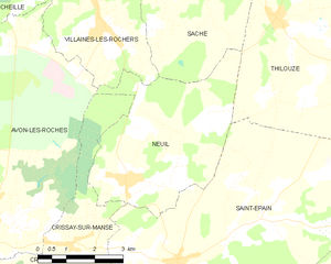
Neuil
- commune in Indre-et-Loire, France
- Country:
- Postal Code: 37190
- Coordinates: 47° 10' 17" N, 0° 30' 45" E
- GPS tracks (wikiloc): [Link]
- Area: 18.82 sq km
- Population: 436
- Web site: [Link]


Pouzay
- commune in Indre-et-Loire, France
- Country:
- Postal Code: 37800
- Coordinates: 47° 4' 55" N, 0° 32' 3" E
- GPS tracks (wikiloc): [Link]
- Area: 14.07 sq km
- Population: 845


Maillé
- commune in Indre-et-Loire, France
- Country:
- Postal Code: 37800
- Coordinates: 47° 3' 10" N, 0° 34' 53" E
- GPS tracks (wikiloc): [Link]
- Area: 15.67 sq km
- Population: 580
- Web site: [Link]


Pussigny
- commune in Indre-et-Loire, France
- Country:
- Postal Code: 37800
- Coordinates: 46° 59' 33" N, 0° 34' 12" E
- GPS tracks (wikiloc): [Link]
- Area: 8.48 sq km
- Population: 172


Marcilly-sur-Vienne
- commune in Indre-et-Loire, France
- Country:
- Postal Code: 37800
- Coordinates: 47° 2' 40" N, 0° 32' 25" E
- GPS tracks (wikiloc): [Link]
- Area: 10.99 sq km
- Population: 543
- Web site: [Link]

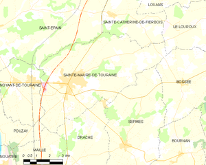
Sainte-Maure-de-Touraine
- commune in Indre-et-Loire, France
- Country:
- Postal Code: 37800
- Coordinates: 47° 6' 44" N, 0° 37' 16" E
- GPS tracks (wikiloc): [Link]
- Area: 40.41 sq km
- Population: 4351
- Web site: [Link]


Ports
- commune in Indre-et-Loire, France
- Country:
- Postal Code: 37800
- Coordinates: 47° 0' 56" N, 0° 33' 14" E
- GPS tracks (wikiloc): [Link]
- Area: 11.01 sq km
- Population: 350
- Web site: [Link]


Nouâtre
- commune in Indre-et-Loire, France
- Country:
- Postal Code: 37800
- Coordinates: 47° 3' 6" N, 0° 33' 6" E
- GPS tracks (wikiloc): [Link]
- Area: 9.65 sq km
- Population: 822
- Web site: [Link]


Saint-Épain
- commune in Indre-et-Loire, France
- Country:
- Postal Code: 37800
- Coordinates: 47° 8' 43" N, 0° 32' 13" E
- GPS tracks (wikiloc): [Link]
- Area: 62.65 sq km
- Population: 1563
- Web site: [Link]

Noyant-de-Touraine
- commune in Indre-et-Loire, France
- Country:
- Postal Code: 37800
- Coordinates: 47° 6' 34" N, 0° 33' 33" E
- GPS tracks (wikiloc): [Link]
- Area: 13.74 sq km
- Population: 1206
- Web site: [Link]