Neuilly-en-Dun (Neuilly-en-Dun)

- commune in Cher, France
- Country:

- Postal Code: 18600
- Coordinates: 46° 47' 57" N, 2° 46' 58" E


- GPS tracks (wikiloc): [Link]
- Area: 29.46 sq km
- Population: 241
- Wikipedia en: wiki(en)
- Wikipedia: wiki(fr)
- Wikidata storage: Wikidata: Q1173468
- Wikipedia Commons Category: [Link]
- Freebase ID: [/m/03mfdg0]
- GeoNames ID: Alt: [6428233]
- SIREN number: [211801618]
- BnF ID: [152495070]
- INSEE municipality code: 18161
Shares border with regions:
Augy-sur-Aubois
- commune in Cher, France
- Country:
- Postal Code: 18600
- Coordinates: 46° 47' 5" N, 2° 50' 38" E
- GPS tracks (wikiloc): [Link]
- Area: 30.46 sq km
- Population: 295

Bannegon
- commune in Cher, France
- Country:
- Postal Code: 18210
- Coordinates: 46° 48' 4" N, 2° 42' 50" E
- GPS tracks (wikiloc): [Link]
- Area: 21.08 sq km
- Population: 258
- Web site: [Link]
Chaumont
- commune in Cher, France
- Country:
- Postal Code: 18350
- Coordinates: 46° 50' 41" N, 2° 45' 11" E
- GPS tracks (wikiloc): [Link]
- AboveSeaLevel: 241 м m
- Area: 2.11 sq km
- Population: 54
Givardon
- commune in Cher, France
- Country:
- Postal Code: 18600
- Coordinates: 46° 50' 24" N, 2° 49' 1" E
- GPS tracks (wikiloc): [Link]
- Area: 21.9 sq km
- Population: 296


Saint-Aignan-des-Noyers
- commune in Cher, France
- Country:
- Postal Code: 18600
- Coordinates: 46° 45' 56" N, 2° 48' 58" E
- GPS tracks (wikiloc): [Link]
- Area: 10.95 sq km
- Population: 100
- Web site: [Link]

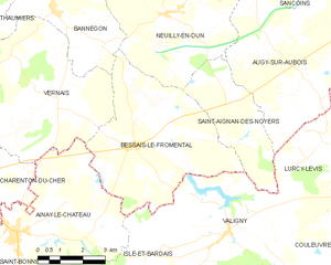
Bessais-le-Fromental
- commune in Cher, France
- Country:
- Postal Code: 18210
- Coordinates: 46° 44' 46" N, 2° 45' 42" E
- GPS tracks (wikiloc): [Link]
- Area: 25.75 sq km
- Population: 333