canton of Sancoins (canton de Sancoins)
- canton of France
- Country:

- Capital: Sancoins
- Coordinates: 46° 49' 58" N, 2° 55' 11" E


- GPS tracks (wikiloc): [Link]
- Wikipedia en: wiki(en)
- Wikipedia: wiki(fr)
- Wikidata storage: Wikidata: Q1727424
- Freebase ID: [/m/05sz9tv]
- INSEE canton code: [1826]
Includes regions:
Augy-sur-Aubois
- commune in Cher, France
- Country:
- Postal Code: 18600
- Coordinates: 46° 47' 5" N, 2° 50' 38" E
- GPS tracks (wikiloc): [Link]
- Area: 30.46 sq km
- Population: 295
Chaumont
- commune in Cher, France
- Country:
- Postal Code: 18350
- Coordinates: 46° 50' 41" N, 2° 45' 11" E
- GPS tracks (wikiloc): [Link]
- AboveSeaLevel: 241 м m
- Area: 2.11 sq km
- Population: 54
Neuvy-le-Barrois
- commune in Cher, France
- Country:
- Postal Code: 18600
- Coordinates: 46° 51' 53" N, 3° 2' 14" E
- GPS tracks (wikiloc): [Link]
- Area: 41.98 sq km
- Population: 148


Neuilly-en-Dun
- commune in Cher, France
- Country:
- Postal Code: 18600
- Coordinates: 46° 47' 57" N, 2° 46' 58" E
- GPS tracks (wikiloc): [Link]
- Area: 29.46 sq km
- Population: 241
Givardon
- commune in Cher, France
- Country:
- Postal Code: 18600
- Coordinates: 46° 50' 24" N, 2° 49' 1" E
- GPS tracks (wikiloc): [Link]
- Area: 21.9 sq km
- Population: 296


Mornay-sur-Allier
- commune in Cher, France
- Country:
- Postal Code: 18600
- Coordinates: 46° 49' 8" N, 3° 1' 44" E
- GPS tracks (wikiloc): [Link]
- Area: 21.62 sq km
- Population: 425
Vereaux
- commune in Cher, France
- Country:
- Postal Code: 18600
- Coordinates: 46° 52' 47" N, 2° 52' 45" E
- GPS tracks (wikiloc): [Link]
- Area: 22.96 sq km
- Population: 143


Saint-Aignan-des-Noyers
- commune in Cher, France
- Country:
- Postal Code: 18600
- Coordinates: 46° 45' 56" N, 2° 48' 58" E
- GPS tracks (wikiloc): [Link]
- Area: 10.95 sq km
- Population: 100
- Web site: [Link]

Grossouvre
- commune in Cher, France
- Country:
- Postal Code: 18600
- Coordinates: 46° 52' 43" N, 2° 56' 14" E
- GPS tracks (wikiloc): [Link]
- Area: 15.75 sq km
- Population: 283
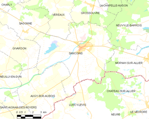
Sancoins
- commune in Cher, France
- Country:
- Postal Code: 18600
- Coordinates: 46° 49' 55" N, 2° 55' 8" E
- GPS tracks (wikiloc): [Link]
- Area: 53.52 sq km
- Population: 3107
- Web site: [Link]


Sagonne
- commune in Cher, France
- Country:
- Postal Code: 18600
- Coordinates: 46° 51' 1" N, 2° 49' 30" E
- GPS tracks (wikiloc): [Link]
- Area: 18.85 sq km
- Population: 182