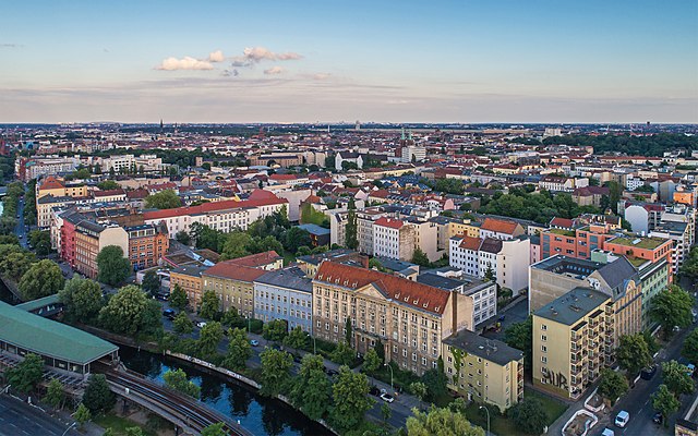
Neukölln (Berlin-Neukölln)


- locality of the borough Neukölln of Berlin, Germany
 Hiking in Neukölln
Neukölln, a vibrant district in Berlin, Germany, is not typically known for traditional hiking trails like those found in mountainous regions. However, there are several spots within and around Neukölln where you can enjoy nature walks, green spaces, and urban hiking experiences.
Key Locations for Walking and Hiking:
-
Tempelhofer Feld: This former airport has been transformed into a massive public park. You can walk, jog, or cycle along the old runways and enjoy the expansive green spaces. It's a great spot for urban hiking, and you can also find areas for picnicking or socializing.
-
Rudolph-Wilde-Park: A lovely park in Neukölln featuring lakes, meadows, and walking paths. It’s an excellent place for a leisurely walk or a picnic.
-
Hasenheide Park: Close to Neukölln, this park offers larger areas for walking and is home to a petting zoo as well. You'll find winding paths that allow for a more immersive nature experience within the urban environment.
-
Sonnenallee: This street has many green facades and small parks along it, making for an interesting urban hike where you can explore local cafes and shops.
-
Biosfera – Botanical Garden and Subtropical Plant Pavilion: While not a hiking trail, it's a great place to explore various plant species and enjoy a serene walking experience.
Nearby Hiking Opportunities:
If you’re willing to venture a bit outside Neukölln, you can find more traditional hiking options:
-
Grunewald Forest: Located 30-40 minutes from Neukölln, Grunewald offers various trails through woods and along lakes, making it a perfect place for a day hike.
-
Saarlandstraße to the Müggelsee: This area south of Neukölln provides scenic routes to lakes and nature reserves, allowing for a beautiful hiking experience.
-
The Berlin Wall Trail: This longer trail follows the path of the former Berlin Wall and connects several parks and historical sites, ideal for those interested in history and scenic walks.
Tips for Hiking in and Around Neukölln:
-
Public Transport: Berlin has an extensive public transport system, making it easy to reach nearby hiking areas using the U-Bahn and S-Bahn.
-
Plan Your Route: Use apps or maps to plan your urban hikes and familiarize yourself with public parks and green spaces in the area.
-
Weather Considerations: Berlin weather can change quickly, so check forecasts and dress appropriately.
-
Stay Water-Ready: Always bring water and snacks, especially if you're planning a longer urban hike.
Although Neukölln may not offer traditional hiking trails, there are plenty of opportunities for enjoyable walks and explorations in nature within this urban environment. Happy hiking!
- Country:

- Postal Code: 12059; 12057; 12055; 12053; 12051; 12049; 12047; 12045; 12043
- Coordinates: 52° 28' 53" N, 13° 26' 7" E


- GPS tracks (wikiloc): [Link]
- AboveSeaLevel: 55 м m
- Area: 11.7 sq km
- Population: 167248
- Wikipedia en: wiki(en)
- Wikipedia: wiki(de)
- Wikidata storage: Wikidata: Q169492
- Wikipedia Commons Gallery: [Link]
- Wikipedia Commons Category: [Link]
- Wikipedia Commons Maps Category: [Link]
- GeoNames ID: Alt: [2864695]
- GND ID: Alt: [4087334-1]
- archINFORM location ID: [3623]
- Library of Congress authority ID: Alt: [n84049705]
Shares border with regions:

Kreuzberg
- locality of Berlin, Germany
Hiking in Kreuzberg
Kreuzberg is a vibrant neighborhood in Berlin, Germany, known for its diverse culture, arts, and nightlife. While it’s primarily an urban area, there are some great outdoor spaces for walking and hiking enthusiasts....
- Country:
- Postal Code: 10969; 10999; 10997; 10967; 10965; 10963; 10961
- Coordinates: 52° 29' 15" N, 13° 23' 0" E
- GPS tracks (wikiloc): [Link]
- AboveSeaLevel: 52 м m
- Area: 10.38 sq km
- Population: 153887


Tempelhof
- locality of Berlin
Hiking in Tempelhof
Tempelhof, a district in Berlin, Germany, is known more for its urban atmosphere than for traditional hiking trails. However, it has unique outdoor spaces that can offer enjoyable walking and exploring experiences for those looking for a more urban hike....
- Country:
- Postal Code: 12279; 12099; 12109; 12105; 12103; 12101
- Coordinates: 52° 28' 0" N, 13° 23' 0" E
- GPS tracks (wikiloc): [Link]
- AboveSeaLevel: 47 м m
- Area: 12.2 sq km
- Population: 59728


Britz
- locality of Berlin
Hiking in Britz
Britz is a neighborhood located in the borough of Neukölln in Berlin, Germany. It is not particularly known for hiking in the traditional sense, as it is more urban and residential in nature. However, there are some fantastic parks and green areas nearby that offer opportunities for leisurely walks and nature exploration....
- Country:
- Postal Code: 12359; 12347
- Coordinates: 52° 27' 0" N, 13° 26' 0" E
- GPS tracks (wikiloc): [Link]
- AboveSeaLevel: 44 м m
- Area: 12.4 sq km
- Population: 41613

Plänterwald
- locality of Berlin
Hiking in Plänterwald
Plänterwald is a beautiful green area located in Berlin, Germany, particularly known for its scenic landscapes and unique blend of nature and urban environment. While it may not be the first location that comes to mind for hiking, it offers a number of trails and paths that can be enjoyable for walkers and nature enthusiasts....
- Country:
- Coordinates: 52° 28' 47" N, 13° 28' 31" E
- GPS tracks (wikiloc): [Link]
- AboveSeaLevel: 31 м m
- Area: 3.01 sq km


Baumschulenweg
- locality of Berlin
Hiking in Baumschulenweg
Baumschulenweg is a neighborhood located in the Treptow-Köpenick district of Berlin, Germany. While it may not be well-known as a traditional hiking destination, there are several outdoor opportunities in and around the area for those looking to enjoy nature and scenic walks....
- Country:
- Coordinates: 52° 27' 54" N, 13° 29' 10" E
- GPS tracks (wikiloc): [Link]
- AboveSeaLevel: 37 м m
- Area: 4.82 sq km
- Population: 17186


Alt-Treptow
- locality of Berlin
Hiking in Alt-Treptow
Alt-Treptow, a district in Berlin, offers a variety of hiking and walking opportunities, particularly along the banks of the Spree River and through its green parks. While it may not be as rugged as traditional hiking destinations, it provides pleasant routes for leisurely walks, nature walks, and urban hiking experiences. Here are some highlights for hiking in Alt-Treptow:...
- Country:
- Coordinates: 52° 29' 24" N, 13° 26' 58" E
- GPS tracks (wikiloc): [Link]
- AboveSeaLevel: 36 м m
- Area: 2.31 sq km
- Population: 10859