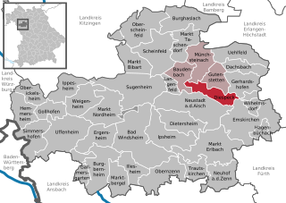
Neustadt (Aisch)-Bad Windsheim (Landkreis Neustadt a. d. Aisch-Bad Windsheim)

- district in Bavaria, Germany
 Hiking in Neustadt (Aisch)-Bad Windsheim
Neustadt (Aisch)-Bad Windsheim, located in the Franconian region of Bavaria, Germany, offers a variety of scenic hiking opportunities for outdoor enthusiasts. The area is characterized by its picturesque landscapes, charming villages, and the rich cultural heritage of Franconia. Here are some highlights of hiking in this region:
Hiking Trails
-
Naturpark Frankenhöhe: This nature park is nearby and offers numerous hiking trails that wind through forests, meadows, and along rivers. You can enjoy the diverse flora and fauna of the region.
-
Franconian Wine Trail (Frankenweinwanderweg): This trail takes you through wine regions, allowing you to enjoy scenic views of vineyards, quaint towns, and the opportunity to taste local wines.
-
Bad Windsheim Trails: The area surrounding Bad Windsheim has designated hiking paths that cater to different skill levels and offer lovely views of the countryside.
-
The Aisch Valley: Explore the routes along the Aisch River, which is known for its natural beauty, and keep an eye out for wildlife such as herons and beavers.
Points of Interest
- Bad Windsheim Spa: After a day of hiking, you can relax at the thermal baths in Bad Windsheim, which provide wellness opportunities amidst beautiful nature.
- Historical Sites: The town of Neustadt boasts historical buildings, including the town hall and several churches, which are worth exploring during your hiking trip.
Tips for Hiking in the Area
- Weather Conditions: Always check the weather forecast before heading out. The region can experience varied weather, so dress in layers.
- Trail Maps: Make sure to carry a detailed map or a GPS device to navigate the trails, as some may not be well-marked.
- Local Recommendations: Don’t hesitate to ask locals for their favorite hiking spots or hidden gems; they can provide insight into the best routes.
Safety Considerations
- Be mindful of safety and your personal fitness level. Choose trails that match your experience.
- Carry enough water, snacks, and a first aid kit during your hikes.
Best Time to Visit
The best time for hiking in Neustadt (Aisch)-Bad Windsheim is during the spring and fall, when the weather is mild, and the scenery is colorful. Summer can also be great, but be prepared for warmer temperatures.
In summary, hiking in Neustadt (Aisch)-Bad Windsheim offers a blend of natural beauty, cultural experiences, and opportunities for relaxation. Whether you're a seasoned hiker or just starting, you'll find plenty to explore and enjoy in this lovely Bavarian region.
- Country:

- Capital: Neustadt an der Aisch
- Licence Plate Code: UFF; SEF; NEA
- Coordinates: 49° 34' 48" N, 10° 30' 0" E


- GPS tracks (wikiloc): [Link]
- AboveSeaLevel: 384 м m
- Area: 1267.54 sq km
- Population: 85686
- Web site: http://www.landkreis-nea.de/
- Wikipedia en: wiki(en)
- Wikipedia: wiki(de)
- Wikidata storage: Wikidata: Q10456
- Wikipedia Commons Category: [Link]
- Wikipedia Commons Maps Category: [Link]
- Freebase ID: [/m/0247j7]
- GeoNames ID: Alt: [3220802]
- VIAF ID: Alt: [234146580]
- OSM relation ID: [62514]
- GND ID: Alt: [4075339-6]
- archINFORM location ID: [2533]
- Library of Congress authority ID: Alt: [n85283541]
- TGN ID: [7077316]
- Bavarikon ID: [ODB_A00000140]
- ISNI: Alt: [0000 0004 0427 7082]
- NUTS code: [DE25A]
- Ringgold ID: [160592]
- German district key: 09575
Includes regions:
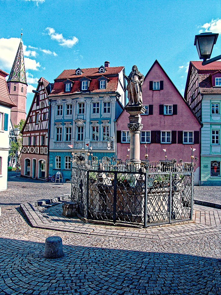

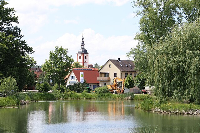
Bad Windsheim
- place in Bavaria, Germany
Hiking in Bad Windsheim
Bad Windsheim, located in Bavaria, Germany, offers a wonderful opportunity for hiking enthusiasts. Known for its charming half-timbered houses and rich history, the area is surrounded by beautiful landscapes, including rolling hills, dense forests, and picturesque countryside....
- Country:
- Postal Code: 91438
- Local Dialing Code: 09841
- Licence Plate Code: NEA
- Coordinates: 49° 30' 0" N, 10° 25' 0" E
- GPS tracks (wikiloc): [Link]
- AboveSeaLevel: 321 м m
- Area: 78.26 sq km
- Population: 11195
- Web site: [Link]

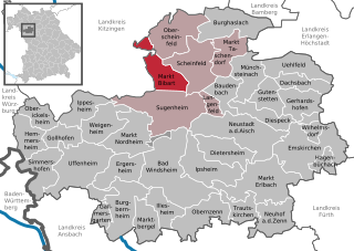
Markt Bibart
- municipality of Germany
Hiking in Markt Bibart
Markt Bibart is a charming village located in Bavaria, Germany, and is surrounded by picturesque landscapes that make it an appealing destination for hiking enthusiasts. The region offers a variety of hiking trails that cater to different skill levels, allowing both beginners and experienced hikers to enjoy the natural beauty....
- Country:
- Postal Code: 91477
- Local Dialing Code: 09162
- Licence Plate Code: NEA
- Coordinates: 49° 38' 0" N, 10° 25' 0" E
- GPS tracks (wikiloc): [Link]
- AboveSeaLevel: 309 м m
- Area: 30.07 sq km
- Population: 1852
- Web site: [Link]


Osing
- unincorporated area in Germany
Hiking in Osing
Hiking in the Osing region, specifically in Freimarkung, offers stunning natural beauty and a variety of trails suited for different skill levels. This area is known for its scenic landscapes, rich biodiversity, and cultural significance. Here are some key points to consider for a hike in Freimarkung:...
- Country:
- Postal Code: 91478
- Coordinates: 49° 33' 58" N, 10° 23' 28" E
- GPS tracks (wikiloc): [Link]
- AboveSeaLevel: 375 м m


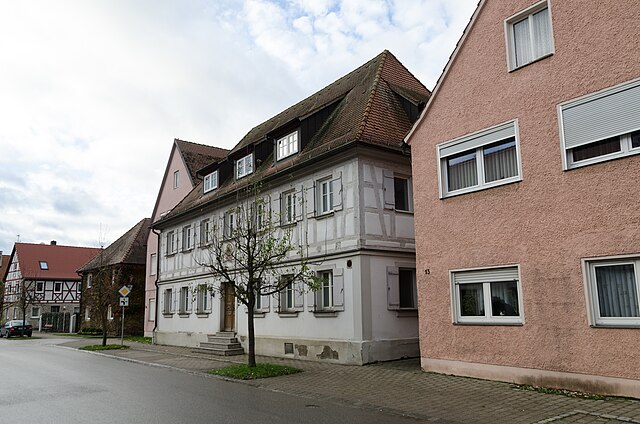
Wilhelmsdorf, Bavaria
- municipality of Germany
Hiking in Wilhelmsdorf, Bavaria
Wilhelmsdorf is a charming village located in Bavaria, Germany, surrounded by picturesque landscapes that make it a great destination for hiking enthusiasts. Here are some highlights and tips for hiking in and around Wilhelmsdorf:...
- Country:
- Postal Code: 91489
- Local Dialing Code: 9104
- Licence Plate Code: NEA
- Coordinates: 49° 34' 0" N, 10° 43' 0" E
- GPS tracks (wikiloc): [Link]
- AboveSeaLevel: 348 м m
- Area: 7.69 sq km
- Population: 1002
- Web site: [Link]


Markt Erlbach
- municipality of Germany
Hiking in Markt Erlbach
Markt Erlbach is a picturesque village located in Bavaria, Germany, surrounded by beautiful landscapes ideal for hiking enthusiasts. The region's charm lies in its rolling hills, woodlands, and meadows, offering various trails suitable for different skill levels....
- Country:
- Postal Code: 91459
- Local Dialing Code: 09106
- Licence Plate Code: NEA
- Coordinates: 49° 29' 0" N, 10° 39' 0" E
- GPS tracks (wikiloc): [Link]
- AboveSeaLevel: 385 м m
- Area: 60.90 sq km
- Population: 5564
- Web site: [Link]


Burghaslach
- municipality of Germany
Hiking in Burghaslach
Burghaslach is a charming municipality in Bavaria, Germany, known for its picturesque landscapes and rural charm. While it may not be as famous for hiking as some of the larger national parks or mountain ranges in Germany, there are still some wonderful hiking opportunities in and around this area....
- Country:
- Postal Code: 96152
- Local Dialing Code: 09552
- Licence Plate Code: NEA
- Coordinates: 49° 43' 0" N, 10° 35' 0" E
- GPS tracks (wikiloc): [Link]
- AboveSeaLevel: 296 м m
- Area: 44.02 sq km
- Population: 2072
- Web site: [Link]

Neustadt an der Aisch
- municipality of Germany in Neustadt (Aisch)-Bad Windsheim in Germany
Hiking in Neustadt an der Aisch
Neustadt an der Aisch, located in Bavaria, Germany, is surrounded by picturesque landscapes and offers various hiking opportunities, perfect for both beginners and experienced hikers. The region is known for its charming mix of woodlands, meadows, and scenic views along small rivers and streams....
- Country:
- Postal Code: 91413
- Local Dialing Code: 09161
- Licence Plate Code: NEA
- Coordinates: 49° 34' 46" N, 10° 36' 41" E
- GPS tracks (wikiloc): [Link]
- AboveSeaLevel: 309 м m
- Area: 61.21 sq km
- Population: 12941
- Web site: [Link]

Burgbernheim
- municipality of Germany
Hiking in Burgbernheim
Burgbernheim, located in Bavaria, Germany, is a charming town that offers beautiful hiking opportunities amidst picturesque landscapes. The region is characterized by rolling hills, lush forests, and scenic meadows, making it an excellent destination for both casual walkers and seasoned hikers....
- Country:
- Postal Code: 91593
- Local Dialing Code: 09843
- Licence Plate Code: NEA
- Coordinates: 49° 27' 0" N, 10° 19' 0" E
- GPS tracks (wikiloc): [Link]
- AboveSeaLevel: 341 м m
- Area: 42.3 sq km
- Population: 2643
- Web site: [Link]


Trautskirchen
- municipality of Germany
Hiking in Trautskirchen
Trautskirchen is a charming village located in Bavaria, Germany, known for its picturesque landscapes and hiking opportunities. The surrounding area offers various trails suitable for different skill levels, making it a great destination for both novice and experienced hikers....
- Country:
- Postal Code: 90619
- Local Dialing Code: 09107
- Licence Plate Code: NEA
- Coordinates: 49° 27' 0" N, 10° 35' 0" E
- GPS tracks (wikiloc): [Link]
- AboveSeaLevel: 340 м m
- Area: 19.81 sq km
- Population: 1141
- Web site: [Link]

Marktbergel
- municipality of Germany
Hiking in Marktbergel
Marktbergel, located in the Bavarian region of Germany, offers a charming backdrop for hiking enthusiasts. The area is characterized by its picturesque landscapes, rolling hills, and serene countryside, making it an ideal spot for outdoor activities....
- Country:
- Postal Code: 91613
- Local Dialing Code: 09843
- Licence Plate Code: NEA
- Coordinates: 49° 27' 0" N, 10° 22' 0" E
- GPS tracks (wikiloc): [Link]
- AboveSeaLevel: 363 м m
- Area: 24.20 sq km
- Population: 1471
- Web site: [Link]

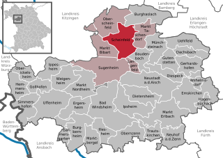
Scheinfeld
- municipality of Germany
Hiking in Scheinfeld
Scheinfeld, located in Bavaria, Germany, offers a charming setting for hiking enthusiasts. Nestled in the Franconian region, it's surrounded by picturesque landscapes, including rolling hills, forests, and meadows. Here are a few highlights for hiking in and around Scheinfeld:...
- Country:
- Postal Code: 91443
- Local Dialing Code: 09162
- Coordinates: 49° 10' 49" N, 11° 10' 6" E
- GPS tracks (wikiloc): [Link]
- AboveSeaLevel: 305 м m
- Area: 45.12 sq km
- Population: 4225
- Web site: [Link]


Neuhof an der Zenn
- municipality of Germany
Hiking in Neuhof an der Zenn
Neuhof an der Zenn is a small village located in Bavaria, Germany, known for its beautiful natural surroundings and scenic hiking opportunities. The area is characterized by its rolling hills, forests, and proximity to the Zenn River, making it a lovely destination for outdoor enthusiasts....
- Country:
- Postal Code: 90616
- Local Dialing Code: 09107
- Licence Plate Code: NEA
- Coordinates: 49° 27' 25" N, 10° 38' 44" E
- GPS tracks (wikiloc): [Link]
- AboveSeaLevel: 330 м m
- Area: 30.94 sq km
- Population: 1756
- Web site: [Link]


Hemmersheim
- municipality of Germany
Hiking in Hemmersheim
Hemmersheim is a small village located in Bavaria, Germany, and while it may not be as well-known as some other hiking destinations, it can offer some unique and peaceful hiking opportunities in the surrounding countryside....
- Country:
- Postal Code: 97258
- Local Dialing Code: 09848
- Licence Plate Code: NEA
- Coordinates: 49° 34' 0" N, 10° 5' 0" E
- GPS tracks (wikiloc): [Link]
- AboveSeaLevel: 389 м m
- Area: 23.86 sq km
- Population: 710
- Web site: [Link]

Simmershofen
- Municipality of Bavaria, Germany
Hiking in Simmershofen
Simmershofen is a quaint village located in the Bavarian region of Germany, known for its beautiful natural landscape and quiet rural charm. Hiking in and around Simmershofen offers a variety of trails that cater to different skill levels, allowing both casual walkers and experienced hikers to explore the scenic beauty of the area....
- Country:
- Postal Code: 97215
- Local Dialing Code: 09848
- Licence Plate Code: NEA
- Coordinates: 49° 31' 0" N, 10° 7' 0" E
- GPS tracks (wikiloc): [Link]
- AboveSeaLevel: 324 м m
- Area: 34.19 sq km
- Population: 1057
- Web site: [Link]

Münchsteinach
- municipality of Germany
Hiking in Münchsteinach
Münchsteinach is a small village located in Bavaria, Germany, nestled in the beautiful countryside near the Franconian region. Hiking here offers a wonderful opportunity to explore picturesque landscapes, charming rural architecture, and a rich natural environment....
- Country:
- Postal Code: 91481
- Local Dialing Code: 09166
- Licence Plate Code: NEA
- Coordinates: 49° 37' 0" N, 10° 35' 0" E
- GPS tracks (wikiloc): [Link]
- AboveSeaLevel: 307 м m
- Area: 29.47 sq km
- Population: 1329
- Web site: [Link]


Oberickelsheim
- municipality of Germany
Hiking in Oberickelsheim
Oberickelsheim is a charming village located in Bavaria, Germany, surrounded by beautiful countryside that offers various hiking opportunities. While it may not be as widely known as some larger hiking destinations, it provides a peaceful environment for nature lovers and hikers looking for scenic trails....
- Country:
- Postal Code: 97258
- Local Dialing Code: 09339
- Licence Plate Code: NEA
- Coordinates: 49° 36' 0" N, 10° 7' 0" E
- GPS tracks (wikiloc): [Link]
- AboveSeaLevel: 320 м m
- Area: 18.22 sq km
- Population: 699
- Web site: [Link]


Gutenstetten
- municipality of Germany
Hiking in Gutenstetten
Gutenstetten is a charming village located in the Franconia region of Bavaria, Germany, and offers a variety of hiking opportunities for those looking to explore the natural beauty of the area. The surrounding landscape includes rolling hills, forests, and fields, making it an ideal setting for outdoor activities....
- Country:
- Postal Code: 91468
- Local Dialing Code: 09161
- Licence Plate Code: NEA
- Coordinates: 49° 37' 0" N, 10° 37' 0" E
- GPS tracks (wikiloc): [Link]
- AboveSeaLevel: 287 м m
- Area: 21.37 sq km
- Population: 1070
- Web site: [Link]


Markt Taschendorf
- municipality of Germany
Hiking in Markt Taschendorf
Markt Taschendorf is a charming town in Bavaria, Germany, known for its scenic landscapes and outdoor activities, including hiking. The surrounding region features a mix of rolling hills, wooded areas, and picturesque farmland, making it an appealing destination for both casual walkers and more serious hikers....
- Country:
- Postal Code: 91480
- Local Dialing Code: 09552
- Licence Plate Code: NEA
- Coordinates: 49° 42' 0" N, 10° 33' 0" E
- GPS tracks (wikiloc): [Link]
- AboveSeaLevel: 343 м m
- Area: 27.73 sq km
- Population: 960
- Web site: [Link]

Markt Nordheim
- municipality of Germany
Hiking in Markt Nordheim
Markt Nordheim is a charming town located in Bavaria, Germany, offering beautiful landscapes and various hiking opportunities for outdoor enthusiasts. The surrounding region features picturesque countryside, forests, and rolling hills, making it ideal for both casual walkers and seasoned hikers....
- Country:
- Postal Code: 91478
- Local Dialing Code: 09165
- Licence Plate Code: NEA
- Coordinates: 49° 34' 0" N, 10° 20' 0" E
- GPS tracks (wikiloc): [Link]
- AboveSeaLevel: 332 м m
- Area: 39.32 sq km
- Population: 1116
- Web site: [Link]


Emskirchen
- municipality of Germany
Hiking in Emskirchen
Emskirchen is a charming small town located in Bavaria, Germany, known for its picturesque landscapes and proximity to nature. While Emskirchen itself may not have major hiking trails, it serves as a great access point to explore the surrounding areas, which offer various hiking opportunities....
- Country:
- Postal Code: 91448
- Local Dialing Code: 09104
- Licence Plate Code: NEA
- Coordinates: 49° 33' 5" N, 10° 43' 4" E
- GPS tracks (wikiloc): [Link]
- AboveSeaLevel: 359 м m
- Area: 67.27 sq km
- Population: 4835
- Web site: [Link]

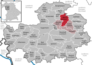
Diespeck
- municipality of Germany
Hiking in Diespeck
Diespeck is a small municipality located in Bavaria, Germany, and while it may not be as widely known as some major hiking destinations, it offers a unique charm for those looking to explore the Bavarian countryside. Here are some key points about hiking in and around Diespeck:...
- Country:
- Postal Code: 91456
- Local Dialing Code: 09161
- Licence Plate Code: NEA
- Coordinates: 49° 36' 0" N, 10° 38' 0" E
- GPS tracks (wikiloc): [Link]
- AboveSeaLevel: 301 м m
- Area: 20.99 sq km
- Population: 2927
- Web site: [Link]


Ipsheim
- municipality of Germany
Hiking in Ipsheim
Ipsheim, a quaint village located in Bavaria, Germany, is surrounded by beautiful landscapes and opportunities for hiking enthusiasts. The region features a mix of scenic trails that wind through lush forests, rolling hills, and picturesque countryside....
- Country:
- Postal Code: 91472
- Local Dialing Code: 09846
- Licence Plate Code: NEA
- Coordinates: 49° 31' 0" N, 10° 28' 0" E
- GPS tracks (wikiloc): [Link]
- AboveSeaLevel: 304 м m
- Area: 42.27 sq km
- Population: 1773
- Web site: [Link]


Illesheim
- municipality of Germany
Hiking in Illesheim
Illesheim is a small village located in Bavaria, Germany, and while it may not be widely known as a hiking destination, it offers access to beautiful countryside and scenic trails that can be appealing to outdoor enthusiasts....
- Country:
- Postal Code: 91471
- Local Dialing Code: 09841
- Licence Plate Code: NEA
- Coordinates: 49° 28' 0" N, 10° 23' 0" E
- GPS tracks (wikiloc): [Link]
- AboveSeaLevel: 321 м m
- Area: 21.42 sq km
- Population: 849
- Web site: [Link]


Obernzenn
- municipality of Germany
Hiking in Obernzenn
Obernzenn is a small town located in the Bavarian region of Germany, known for its beautiful landscapes and rich history. Hiking around Obernzenn offers a variety of trails that cater to different skill levels, making it an excellent destination for both casual walkers and experienced hikers. Here are some highlights of hiking in the area:...
- Country:
- Postal Code: 91619
- Local Dialing Code: 09844
- Licence Plate Code: NEA
- Coordinates: 49° 27' 0" N, 10° 28' 0" E
- GPS tracks (wikiloc): [Link]
- AboveSeaLevel: 376 м m
- Area: 39.67 sq km
- Population: 2503
- Web site: [Link]


Baudenbach
- municipality of Germany
Hiking in Baudenbach
Baudenbach, a charming location in Germany, offers a range of hiking opportunities through picturesque landscapes and natural surroundings. While it's not one of the most widely known hiking destinations, it provides a serene environment for outdoor enthusiasts to explore....
- Country:
- Postal Code: 91460
- Local Dialing Code: 09164
- Licence Plate Code: NEA
- Coordinates: 49° 37' 0" N, 10° 31' 0" E
- GPS tracks (wikiloc): [Link]
- AboveSeaLevel: 301 м m
- Area: 22.09 sq km
- Population: 970
- Web site: [Link]


Ippesheim
- municipality of Germany
Hiking in Ippesheim
Ippesheim, located in Bavaria, Germany, offers a charming experience for hikers, with its picturesque landscapes and rich natural environment. While not as famous as some larger hiking destinations, it provides scenic trails that showcase the region's rolling hills, forests, and agricultural landscapes....
- Country:
- Postal Code: 97258
- Local Dialing Code: 09339
- Licence Plate Code: NEA
- Coordinates: 49° 36' 9" N, 10° 13' 27" E
- GPS tracks (wikiloc): [Link]
- AboveSeaLevel: 291 м m
- Area: 23.56 sq km
- Population: 1165
- Web site: [Link]


Dietersheim
- municipality of Germany
Hiking in Dietersheim
Dietersheim, a small village in Bavaria, Germany, offers a charming environment for hiking enthusiasts. While it may not be as widely known as some larger hiking destinations, there are several appealing aspects to hiking in and around Dietersheim....
- Country:
- Postal Code: 91463
- Local Dialing Code: 09161
- Licence Plate Code: NEA
- Coordinates: 49° 34' 0" N, 10° 31' 0" E
- GPS tracks (wikiloc): [Link]
- AboveSeaLevel: 301 м m
- Area: 31.21 sq km
- Population: 1807
- Web site: [Link]


Oberscheinfeld
- municipality of Germany
Hiking in Oberscheinfeld
Oberscheinfeld is a quaint village located in Bavaria, Germany, known for its picturesque landscapes and scenic trails, making it a great destination for hiking enthusiasts. Here are some highlights to consider when hiking in and around Oberscheinfeld:...
- Country:
- Postal Code: 91483
- Local Dialing Code: 09167
- Licence Plate Code: NEA
- Coordinates: 49° 43' 0" N, 10° 25' 0" E
- GPS tracks (wikiloc): [Link]
- AboveSeaLevel: 331 м m
- Area: 42.27 sq km
- Population: 1205
- Web site: [Link]


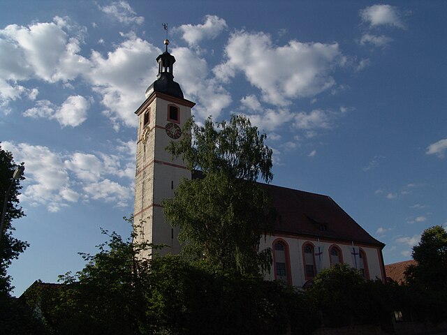
Uehlfeld
- municipality of Germany
Hiking in Uehlfeld
Uehlfeld, located in Germany, offers a charming backdrop for hiking enthusiasts. While it may not be as widely known as larger hiking regions, it is surrounded by picturesque landscapes, forests, and rolling hills typical of the Franconian countryside in Bavaria. Here are some things you might consider when hiking in and around Uehlfeld:...
- Country:
- Postal Code: 91486
- Local Dialing Code: 09163
- Licence Plate Code: NEA
- Coordinates: 49° 40' 0" N, 10° 43' 0" E
- GPS tracks (wikiloc): [Link]
- AboveSeaLevel: 278 м m
- Area: 31.23 sq km
- Population: 2182
- Web site: [Link]


Dachsbach
- municipality of Germany
Hiking in Dachsbach
Dachsbach is a beautiful area located in Germany, known for its stunning natural landscapes and hiking opportunities. Nestled in Bavaria, it offers a diverse range of trails suitable for different skill levels, from leisurely walks to more challenging hikes....
- Country:
- Postal Code: 91462
- Local Dialing Code: 09163
- Licence Plate Code: NEA
- Coordinates: 49° 38' 25" N, 10° 42' 23" E
- GPS tracks (wikiloc): [Link]
- AboveSeaLevel: 280 м m
- Area: 20.58 sq km
- Population: 1721
- Web site: [Link]


Hagenbüchach
- municipality of Germany
Hiking in Hagenbüchach
Hagenbüchach, located in Bavaria, Germany, offers a variety of hiking opportunities for outdoor enthusiasts. The area is characterized by picturesque landscapes, including rolling hills, forests, and agricultural fields, making it an appealing destination for both casual walkers and experienced hikers....
- Country:
- Postal Code: 91469
- Local Dialing Code: 09101
- Licence Plate Code: NEA
- Coordinates: 49° 31' 0" N, 10° 46' 0" E
- GPS tracks (wikiloc): [Link]
- AboveSeaLevel: 383 м m
- Area: 11.50 sq km
- Population: 820
- Web site: [Link]

Gerhardshofen
- municipality of Germany
Hiking in Gerhardshofen
Gerhardshofen is a small village located in Bavaria, Germany, and while it may not be widely known as a hiking destination, the surrounding areas offer pleasant opportunities for outdoor enthusiasts. Here’s what you can expect when hiking near Gerhardshofen:...
- Country:
- Postal Code: 91466
- Local Dialing Code: 09163
- Licence Plate Code: NEA
- Coordinates: 49° 37' 0" N, 10° 41' 0" E
- GPS tracks (wikiloc): [Link]
- AboveSeaLevel: 288 м m
- Area: 27.20 sq km
- Population: 1389
- Web site: [Link]


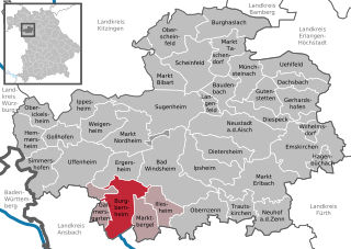
Ergersheim, Middle Franconia
- municipality of Germany
Hiking in Ergersheim, Middle Franconia
Ergersheim, located in Middle Franconia, Germany, is a charming village that offers various hiking opportunities in the surrounding countryside. The area is characterized by picturesque landscapes, rolling hills, and agricultural land, making it suitable for both casual walks and more dedicated hikes....
- Country:
- Postal Code: 91465
- Local Dialing Code: 09847
- Licence Plate Code: NEA
- Coordinates: 49° 30' 40" N, 10° 19' 37" E
- GPS tracks (wikiloc): [Link]
- AboveSeaLevel: 334 м m
- Area: 30.04 sq km
- Population: 1047
- Web site: [Link]


Weigenheim
- municipality of Germany
Hiking in Weigenheim
Weigenheim is a charming village in the Alsace region of France, known for its picturesque landscapes and hiking opportunities. The area is characterized by rolling hills, vineyards, and beautiful natural scenery, making it an appealing destination for outdoor enthusiasts....
- Country:
- Postal Code: 97215
- Local Dialing Code: 09842
- Licence Plate Code: NEA
- Coordinates: 49° 34' 0" N, 10° 16' 0" E
- GPS tracks (wikiloc): [Link]
- AboveSeaLevel: 332 м m
- Area: 32.66 sq km
- Population: 972
- Web site: [Link]


Sugenheim
- municipality of Germany
Hiking in Sugenheim
Sugenheim is a small municipality in Bavaria, Germany, known for its picturesque landscapes and scenic hiking trails. While it may not be as widely recognized as some larger tourist destinations, it offers a charming experience for hikers looking to explore the beauty of the Franconian countryside....
- Country:
- Postal Code: 91484
- Local Dialing Code: 09165
- Licence Plate Code: NEA
- Coordinates: 49° 36' 0" N, 10° 25' 0" E
- GPS tracks (wikiloc): [Link]
- AboveSeaLevel: 312 м m
- Area: 63.41 sq km
- Population: 2333
- Web site: [Link]


Gollhofen
- municipality of Germany
Hiking in Gollhofen
Gollhofen is a small village located in Bavaria, Germany, known for its picturesque surroundings and outdoor activities, including hiking. While it may not be as widely recognized as larger hiking destinations, Gollhofen offers a peaceful and scenic environment for those looking to explore nature....
- Country:
- Postal Code: 97258
- Local Dialing Code: 09339
- Licence Plate Code: NEA
- Coordinates: 49° 34' 0" N, 10° 11' 0" E
- GPS tracks (wikiloc): [Link]
- AboveSeaLevel: 320 м m
- Area: 17.03 sq km
- Population: 786
- Web site: [Link]


Langenfeld
- municipality in Bavaria, Germany
Hiking in Langenfeld
Langenfeld, located in Bavarian Germany, is a beautiful destination for hiking enthusiasts. Nestled in the scenic Altmühltal Nature Park, the area offers a variety of trails that cater to different skill levels and preferences. Here are some highlights about hiking in Langenfeld:...
- Country:
- Postal Code: 91474
- Local Dialing Code: 09164
- Licence Plate Code: NEA
- Coordinates: 49° 37' 0" N, 10° 31' 0" E
- GPS tracks (wikiloc): [Link]
- AboveSeaLevel: 303 м m
- Area: 7.22 sq km
- Population: 779
- Web site: [Link]

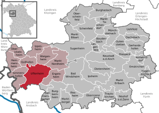
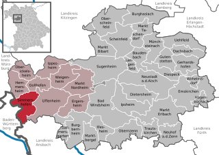
Uffenheim
- municipality in Germany
Hiking in Uffenheim
Uffenheim is a small town located in Bavaria, Germany, and while it may not be the first place that comes to mind for hiking, the surrounding region offers some lovely trails and opportunities for outdoor activities. Here are some tips and insights into hiking around Uffenheim:...
- Country:
- Postal Code: 97215
- Local Dialing Code: 09842
- Coordinates: 49° 31' 0" N, 10° 15' 0" E
- GPS tracks (wikiloc): [Link]
- AboveSeaLevel: 326 м m
- Area: 59.47 sq km
- Population: 5694
- Web site: [Link]


Gallmersgarten
- municipality of Germany
Hiking in Gallmersgarten
Gallmersgarten is a picturesque area located within the Franconian region of Germany, particularly known for its scenic landscapes and opportunities for outdoor activities, including hiking. Here are some key points to consider if you're planning a hiking trip in Gallmersgarten:...
- Country:
- Postal Code: 91605
- Local Dialing Code: 09843
- Licence Plate Code: NEA
- Coordinates: 49° 27' 0" N, 10° 16' 0" E
- GPS tracks (wikiloc): [Link]
- AboveSeaLevel: 356 м m
- Area: 15.17 sq km
- Population: 782
- Web site: [Link]
Shares border with regions:
Bamberg
- district in Bavaria, Germany
Hiking in Bamberg
Bamberg district, located in Bavaria, Germany, offers a variety of scenic hiking opportunities amidst its charming landscapes, historical sites, and cultural attractions. Here’s an overview of what you can expect when hiking in the region:...
- Country:
- Capital: Bamberg
- Licence Plate Code: BA
- Coordinates: 49° 49' 48" N, 10° 49' 48" E
- GPS tracks (wikiloc): [Link]
- AboveSeaLevel: 275 м m
- Area: 1168.00 sq km
- Population: 119829
- Web site: [Link]

Erlangen-Höchstadt
- district in Bavaria, Germany
Hiking in Erlangen-Höchstadt
Erlangen-Höchstadt is a scenic district in Bavaria, Germany, known for its beautiful landscapes and opportunities for outdoor activities, including hiking. The region offers a mix of rolling hills, woodlands, and agricultural fields, making it suitable for both casual and more adventurous hikers....
- Country:
- Capital: Erlangen
- Licence Plate Code: ERH
- Coordinates: 49° 40' 12" N, 10° 49' 48" E
- GPS tracks (wikiloc): [Link]
- AboveSeaLevel: 287 м m
- Area: 56465.80 sq km
- Population: 134136
- Web site: [Link]

Ansbach
- district in Bavaria, Germany
Hiking in Ansbach
Ansbach district, located in the region of Bavaria, Germany, offers a variety of hiking opportunities suitable for different skill levels. The region is characterized by its picturesque landscapes, including rolling hills, forests, and historical sites, making it a great destination for outdoor enthusiasts....
- Country:
- Capital: Ansbach
- Licence Plate Code: ROT; FEU; DKB; AN
- Coordinates: 49° 19' 48" N, 10° 30' 0" E
- GPS tracks (wikiloc): [Link]
- AboveSeaLevel: 426 м m
- Area: 1972.00 sq km
- Population: 157632
- Web site: [Link]

Fürth
- district in Bavaria, Germany
Hiking in Fürth
Fürth, located in Bavaria, Germany, offers a variety of hiking opportunities that cater to different skill levels and preferences. The area is characterized by beautiful hills, forests, and rivers, making it a great spot for outdoor enthusiasts....
- Country:
- Capital: Zirndorf
- Licence Plate Code: FÜ
- Coordinates: 49° 25' 0" N, 10° 50' 0" E
- GPS tracks (wikiloc): [Link]
- AboveSeaLevel: 397 м m
- Area: 308.00 sq km
- Population: 116193
- Web site: [Link]

Würzburg
- district of Bavaria, Germany
Hiking in Würzburg
Würzburg, located in the Lower Franconia region of Bavaria, Germany, is surrounded by beautiful landscapes, making it a great starting point for hiking adventures. Here are some highlights and considerations for hiking in and around the Würzburg district:...
- Country:
- Capital: Würzburg
- Licence Plate Code: OCH; WÜ
- Coordinates: 49° 39' 36" N, 10° 0' 0" E
- GPS tracks (wikiloc): [Link]
- AboveSeaLevel: 346 м m
- Area: 967.56 sq km
- Population: 161340
- Web site: [Link]

Kitzingen
- district in Bavaria, Germany
Hiking in Kitzingen
Kitzingen district, located in Bavaria, Germany, offers a variety of scenic landscapes suitable for hiking. The region is characterized by vineyards, rolling hills, and charming riverside paths along the Main River. Here are some highlights for hiking in Kitzingen district:...
- Country:
- Capital: Kitzingen
- Licence Plate Code: KT
- Coordinates: 49° 45' 0" N, 10° 15' 36" E
- GPS tracks (wikiloc): [Link]
- AboveSeaLevel: 231 м m
- Area: 684.00 sq km
- Population: 79304
- Web site: [Link]


Main-Tauber
- district of Baden-Württemberg, Germany
Hiking in Main-Tauber
Main-Tauber-Kreis, located in the Baden-Württemberg state of Germany, is a beautiful region known for its stunning landscapes, historic towns, and rich cultural heritage, making it an excellent destination for hiking enthusiasts. Here are some key aspects of hiking in this picturesque area:...
- Country:
- Capital: Tauberbischofsheim
- Licence Plate Code: TBB
- Coordinates: 49° 34' 12" N, 9° 42' 36" E
- GPS tracks (wikiloc): [Link]
- AboveSeaLevel: 190 м m
- Area: 1304.41 sq km
- Population: 132181
- Web site: [Link]