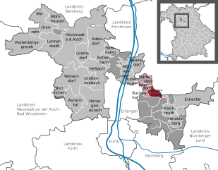
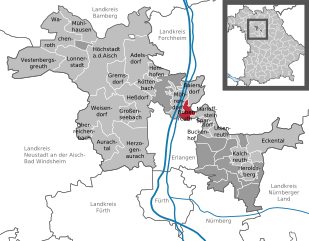
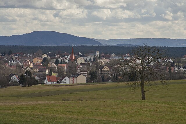
Erlangen-Höchstadt (Landkreis Erlangen-Höchstadt)

- district in Bavaria, Germany
 Hiking in Erlangen-Höchstadt
Erlangen-Höchstadt is a scenic district in Bavaria, Germany, known for its beautiful landscapes and opportunities for outdoor activities, including hiking. The region offers a mix of rolling hills, woodlands, and agricultural fields, making it suitable for both casual and more adventurous hikers.
Hiking Trails
-
Fränkische Schweiz (Franconian Switzerland): While not exclusively in Erlangen-Höchstadt, this nearby area is famous for its stunning limestone formations, caves, and picturesque villages. It offers numerous trails of varying lengths and difficulties.
-
Nature Reserves: The region includes several nature reserves that provide well-marked hiking paths. These areas are great for birdwatching and experiencing local flora and fauna.
-
The Höchstadt Area: This area features a network of trails that can take you through orchards, small forests, and alongside rivers, offering a quieter and more serene hiking experience.
-
Muggenhof Trail: A local trail that connects different points of interest within Erlangen-Höchstadt, often favored by families and casual hikers.
-
Schwarzachtal Trail: This scenic route follows the Schwarzach River, showcasing beautiful landscapes and diverse ecosystems.
Tips for Hiking in Erlangen-Höchstadt
-
Maps and Guides: Always carry a local map, as some trails may not be well-marked. Consider downloading hiking apps that provide offline maps.
-
Weather Awareness: The weather can change rapidly, especially in wooded areas, so check forecasts and be prepared for rain or sudden temperature changes.
-
Support Local Conservation: Stay on marked trails to protect the local environment and wildlife.
-
Hydration and Snacks: Always carry enough water and some snacks, especially on longer hikes.
-
Hiking Groups: Consider joining local hiking clubs or groups if you're looking for companionship or guided hikes. This can enhance your experience and provide you with insights from seasoned hikers.
Overall, hiking in Erlangen-Höchstadt offers a wonderful opportunity to enjoy the natural beauty of Bavaria, with options suitable for all levels of experience. Enjoy your time on the trails!
- Country:

- Capital: Erlangen
- Licence Plate Code: ERH
- Coordinates: 49° 40' 12" N, 10° 49' 48" E


- GPS tracks (wikiloc): [Link]
- AboveSeaLevel: 287 м m
- Area: 56465.80 sq km
- Population: 134136
- Web site: http://www.erlangen-hoechstadt.de/
- Wikipedia en: wiki(en)
- Wikipedia: wiki(de)
- Wikidata storage: Wikidata: Q10447
- Wikipedia Commons Category: [Link]
- Wikipedia Commons Maps Category: [Link]
- Freebase ID: [/m/01n73m]
- GeoNames ID: Alt: [3220799]
- VIAF ID: Alt: [237683101]
- OSM relation ID: [62448]
- GND ID: Alt: [4015302-2]
- archINFORM location ID: [4643]
- TGN ID: [7077319]
- Bavarikon ID: [ODB_A00000071]
- ISNI: Alt: [0000 0004 0565 4695]
- NUTS code: [DE257]
- BabelNet ID: [02003493n]
- German district key: 09572
Includes regions:

Dormitzer Forst
- unincorporated area in Germany
Hiking in Dormitzer Forst
Dormitzer Forst, located in Bavaria, Germany, is a beautiful and serene forested area that offers a variety of hiking opportunities suitable for all skill levels. Here are some key points to know about hiking in Dormitzer Forst:...
- Country:
- Coordinates: 49° 33' 48" N, 11° 5' 27" E
- GPS tracks (wikiloc): [Link]


Erlenstegener Forst
- unincorporated area in Germany
Hiking in Erlenstegener Forst
Erlenstegener Forst is a beautiful area for hiking, located in Germany. This forested region offers a range of trails suitable for different skill levels, making it an appealing destination for both casual hikers and experienced outdoors enthusiasts....
- Country:
- Coordinates: 49° 29' 20" N, 11° 9' 30" E
- GPS tracks (wikiloc): [Link]

Forst Tennenlohe
- unincorporated area in Germany
Hiking in Forst Tennenlohe
Forst Tennenlohe is a beautiful forest area located near Erlangen in Germany. It offers visitors a variety of hiking opportunities amidst serene natural surroundings. Here are some key points to consider if you're planning a hike there:...
- Country:
- Coordinates: 49° 33' 23" N, 11° 3' 0" E
- GPS tracks (wikiloc): [Link]
Geschaidt
- unincorporated area in Germany
Hiking in Geschaidt
Geschaidt is a picturesque area that offers beautiful hiking opportunities, often characterized by serene landscapes, charming villages, and diverse terrain. While specific trails may vary based on the exact location and regional features, there are generally a few key points to consider when hiking in this region:...
- Country:
- Coordinates: 49° 32' 17" N, 11° 10' 58" E
- GPS tracks (wikiloc): [Link]


Hemhofen
- municipality of Germany
Hiking in Hemhofen
Hemhofen, a small village located in Bavaria, Germany, is surrounded by beautiful countryside that offers numerous hiking opportunities. The region is characterized by its scenic landscapes, including rolling hills, forests, and picturesque fields. Here are some key points to consider when hiking in Hemhofen:...
- Country:
- Postal Code: 91334
- Local Dialing Code: 09195
- Licence Plate Code: ERH
- Coordinates: 49° 40' 59" N, 10° 55' 59" E
- GPS tracks (wikiloc): [Link]
- AboveSeaLevel: 317 м m
- Area: 6.77 sq km
- Population: 4278
- Web site: [Link]

Herzogenaurach
- municipality of Germany
Hiking in Herzogenaurach
Herzogenaurach, a charming town located in Bavaria, Germany, is known for its historical significance and outdoor activities, including hiking. While it may not be as renowned for hiking as some other regions in Germany, it offers several picturesque trails and nature spots that can be appealing for outdoor enthusiasts....
- Country:
- Postal Code: 91074
- Local Dialing Code: 09132
- Licence Plate Code: ERH
- Coordinates: 49° 34' 0" N, 10° 53' 0" E
- GPS tracks (wikiloc): [Link]
- AboveSeaLevel: 301 м m
- Area: 47.60 sq km
- Population: 23095
- Web site: [Link]
Heßdorf
- municipality of Germany
Hiking in Heßdorf
Heßdorf, a municipality in Bavaria, Germany, is surrounded by beautiful landscapes and offers various opportunities for hiking enthusiasts. While it may not be as widely known as some other hiking destinations, its proximity to nature provides a peaceful environment for outdoor activities....
- Country:
- Postal Code: 91093
- Local Dialing Code: 09135
- Licence Plate Code: ERH
- Coordinates: 49° 37' 59" N, 10° 55' 0" E
- GPS tracks (wikiloc): [Link]
- AboveSeaLevel: 290 м m
- Area: 24.79 sq km
- Population: 2634
- Web site: [Link]


Baiersdorf
- municipality of Germany
Hiking in Baiersdorf
Baiersdorf is a small town located in Bavaria, Germany, near the cities of Erlangen and Nuremberg. While it might not be one of the most well-known hiking destinations, the surrounding areas offer various trails and natural beauty that make for enjoyable hiking experiences....
- Country:
- Postal Code: 91083
- Local Dialing Code: 09133
- Licence Plate Code: ERH
- Coordinates: 49° 39' 0" N, 11° 1' 0" E
- GPS tracks (wikiloc): [Link]
- AboveSeaLevel: 269 м m
- Area: 11.79 sq km
- Population: 7489
- Web site: [Link]


Kalchreuther Forst
- unincorporated area in Germany
Hiking in Kalchreuther Forst
Kalchreuther Forst is a beautiful forested area located in the Franconian region of Bavaria, Germany. It's an excellent destination for hikers looking to enjoy nature, explore diverse trails, and appreciate the local flora and fauna. Here are some highlights and tips for hiking in Kalchreuther Forst:...
- Country:
- Coordinates: 49° 32' 0" N, 11° 6' 56" E
- GPS tracks (wikiloc): [Link]


Kraftshofer Forst
- unincorporated area in Germany
Hiking in Kraftshofer Forst
Kraftshofer Forst, located in Germany, is an excellent destination for hiking enthusiasts looking to explore beautiful natural landscapes, lush forests, and serene trails. Here are some highlights and tips for hiking in this area:...
- Country:
- Coordinates: 49° 30' 50" N, 11° 5' 25" E
- GPS tracks (wikiloc): [Link]


Lonnerstadt
- place in Bavaria, Germany
Hiking in Lonnerstadt
As of my last knowledge update in October 2021, specific information about hiking in Lonnerstadt, a small town in Germany, might be limited. However, I can offer some general advice and tips for hiking in this region or similar areas....
- Country:
- Postal Code: 91475
- Local Dialing Code: 09193
- Licence Plate Code: ERH
- Coordinates: 49° 42' 0" N, 10° 46' 0" E
- GPS tracks (wikiloc): [Link]
- AboveSeaLevel: 288 м m
- Area: 22.72 sq km
- Population: 1608
- Web site: [Link]


Mark
- unincorporated area in Germany
Hiking in Mark
Mark, as a gemeindefreies Gebiet (unincorporated area) in Germany, is characterized by its natural landscapes and opportunities for outdoor activities, including hiking. While specifics can vary based on the exact location within the area, here are some general tips and highlights for hiking in areas like Mark:...
- Country:
- Coordinates: 49° 39' 40" N, 10° 57' 41" E
- GPS tracks (wikiloc): [Link]


Marloffstein
- place in Bavaria, Germany
Hiking in Marloffstein
Marloffstein is a charming village located in the Franconia region of Germany, near Nuremberg. It offers scenic hiking opportunities, with trails that showcase the natural beauty of the surrounding area, including forested landscapes and hilly terrains....
- Country:
- Postal Code: 91080
- Local Dialing Code: 09131
- Licence Plate Code: ERH
- Coordinates: 49° 37' 0" N, 11° 4' 0" E
- GPS tracks (wikiloc): [Link]
- AboveSeaLevel: 355 м m
- Area: 6.63 sq km
- Population: 1556
- Web site: [Link]


Mühlhausen
- place in Bavaria, Germany
Hiking in Mühlhausen
Mühlhausen, located in Middle Franconia, Germany, is surrounded by picturesque landscapes and offers a variety of hiking opportunities. The region is characterized by rolling hills, lush forests, and charming villages, making it a great destination for outdoor enthusiasts....
- Country:
- Postal Code: 96172
- Local Dialing Code: 09548
- Licence Plate Code: ERH
- Coordinates: 49° 45' 0" N, 10° 46' 0" E
- GPS tracks (wikiloc): [Link]
- AboveSeaLevel: 275 м m
- Area: 16.57 sq km
- Population: 1373
- Web site: [Link]


Neunhofer Forst
- unincorporated area in Germany
Hiking in Neunhofer Forst
Neunhofer Forst is a scenic forested area located in Germany, known for its lush greenery, tranquil pathways, and diverse wildlife. It offers a variety of hiking opportunities for all skill levels, ranging from leisurely walks to more challenging treks....
- Country:
- Coordinates: 49° 32' 0" N, 11° 5' 0" E
- GPS tracks (wikiloc): [Link]


Oberreichenbach
- municipality in Bavaria, Germany
Hiking in Oberreichenbach
Oberreichenbach, located in Bavaria, Germany, is a charming destination for hiking enthusiasts. Nestled within the picturesque landscapes of the Bavarian countryside, it offers a variety of trails suitable for different skill levels, from leisurely walks to more challenging hikes....
- Country:
- Postal Code: 91097
- Local Dialing Code: 09104
- Licence Plate Code: ERH
- Coordinates: 49° 34' 59" N, 10° 46' 0" E
- GPS tracks (wikiloc): [Link]
- AboveSeaLevel: 353 м m
- Area: 4.83 sq km
- Population: 763
- Web site: [Link]


Spardorf
- human settlement in Germany
Hiking in Spardorf
Spardorf is a charming village located near Erlangen in Bavaria, Germany, surrounded by picturesque landscapes that offer various hiking opportunities. Here are some key points about hiking in and around Spardorf:...
- Country:
- Postal Code: 91080
- Local Dialing Code: 09131
- Licence Plate Code: ERH
- Coordinates: 49° 36' 31" N, 11° 3' 21" E
- GPS tracks (wikiloc): [Link]
- AboveSeaLevel: 312 м m
- Area: 3.22 sq km
- Population: 1908
- Web site: [Link]

Uttenreuth
- municipality in district Erlangen-Höchstadt, Bavaria, Germany
Hiking in Uttenreuth
Uttenreuth, a small municipality in Bavaria, Germany, is located near the city of Erlangen and offers various hiking opportunities in the surrounding Franconian countryside. The region is characterized by beautiful landscapes, including forests, fields, and rolling hills, making it ideal for both casual walkers and more serious hikers....
- Country:
- Postal Code: 91080
- Local Dialing Code: 09131
- Licence Plate Code: ERH
- Coordinates: 49° 36' 0" N, 11° 4' 0" E
- GPS tracks (wikiloc): [Link]
- AboveSeaLevel: 291 м m
- Area: 5.93 sq km
- Population: 4608
- Web site: [Link]


Adelsdorf
- municipality of Germany
Hiking in Adelsdorf
Adelsdorf is a charming village located in Bavaria, Germany, nestled within the lush Franconian landscape. While it might not be as widely known as some of the larger hiking destinations in Germany, it provides a lovely backdrop for those looking to explore the natural beauty of the region....
- Country:
- Postal Code: 91325
- Local Dialing Code: 09195
- Licence Plate Code: ERH
- Coordinates: 49° 43' 0" N, 10° 54' 0" E
- GPS tracks (wikiloc): [Link]
- AboveSeaLevel: 264 м m
- Area: 31.67 sq km
- Population: 5725
- Web site: [Link]


Eckental
- municipality of Germany
Hiking in Eckental
Eckental is a charming town located in Bavaria, Germany, which offers a variety of hiking opportunities for outdoor enthusiasts. Nestled in a picturesque landscape characterized by rolling hills, forests, and meandering rivers, it's a great destination for both novice and experienced hikers....
- Country:
- Postal Code: 90542
- Local Dialing Code: 09192; 09126
- Licence Plate Code: ERH
- Coordinates: 49° 34' 0" N, 11° 15' 0" E
- GPS tracks (wikiloc): [Link]
- AboveSeaLevel: 344 м m
- Area: 29.71 sq km
- Population: 11612
- Web site: [Link]

Bubenreuth
- municipality of Germany
Hiking in Bubenreuth
Bubenreuth, a charming municipality located in Bavaria, Germany, offers various opportunities for hiking and enjoying nature. Being close to the beautiful Franconian countryside and the famous Frankenjura climbing region, it attracts outdoor enthusiasts....
- Country:
- Postal Code: 91088
- Local Dialing Code: 09131
- Licence Plate Code: ERH
- Coordinates: 49° 37' 40" N, 11° 1' 2" E
- GPS tracks (wikiloc): [Link]
- AboveSeaLevel: 288 м m
- Area: 4.13 sq km
- Population: 4104
- Web site: [Link]


Weisendorf
- municipality of Germany
Hiking in Weisendorf
Weisendorf, located in Bavaria, Germany, is an excellent destination for hiking enthusiasts. Nestled in the beautiful Franconian landscape, it offers a variety of hiking trails that cater to different skill levels, from easy walks suitable for families to more challenging routes for seasoned hikers....
- Country:
- Postal Code: 91085
- Local Dialing Code: 09135
- Licence Plate Code: ERH
- Coordinates: 49° 37' 0" N, 10° 50' 0" E
- GPS tracks (wikiloc): [Link]
- AboveSeaLevel: 308 м m
- Area: 36.72 sq km
- Population: 4089
- Web site: [Link]

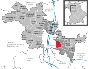
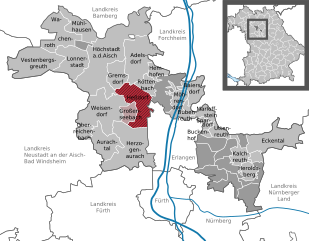
Großenseebach
- municipality of Germany
Hiking in Großenseebach
Großenseebach, located in the beautiful state of Bavaria, Germany, offers a range of hiking opportunities that cater to various skill levels. The surrounding area is characterized by picturesque landscapes, rolling hills, lush forests, and scenic views....
- Country:
- Postal Code: 91091
- Local Dialing Code: 09135
- Licence Plate Code: ERH
- Coordinates: 49° 37' 53" N, 10° 52' 38" E
- GPS tracks (wikiloc): [Link]
- AboveSeaLevel: 296 м m
- Area: 7.21 sq km
- Population: 1849
- Web site: [Link]

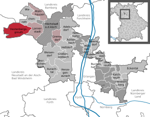
Vestenbergsgreuth
- municipality of Germany
Hiking in Vestenbergsgreuth
Vestenbergsgreuth, a small village in Bavaria, Germany, offers beautiful natural landscapes and a tranquil hiking experience. The region is surrounded by picturesque rolling hills, forests, and meadows, making it a great destination for hiking enthusiasts....
- Country:
- Postal Code: 91487
- Local Dialing Code: 09163
- Licence Plate Code: ERH
- Coordinates: 49° 40' 0" N, 10° 37' 0" E
- GPS tracks (wikiloc): [Link]
- AboveSeaLevel: 305 м m
- Area: 31.85 sq km
- Population: 1132
- Web site: [Link]


Wachenroth
- municipality of Germany
Hiking in Wachenroth
Wachenroth is a small village located in Bavaria, Germany, and while it might not be the most well-known hiking destination, it offers some lovely opportunities for outdoor enthusiasts due to its picturesque countryside and proximity to more extensive hiking areas....
- Country:
- Postal Code: 96193
- Local Dialing Code: 09548
- Licence Plate Code: ERH
- Coordinates: 49° 45' 0" N, 10° 43' 0" E
- GPS tracks (wikiloc): [Link]
- AboveSeaLevel: 285 м m
- Area: 23.16 sq km
- Population: 1440
- Web site: [Link]


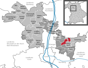
Kalchreuth
- municipality of Germany
Hiking in Kalchreuth
Kalchreuth, located in Bavaria, Germany, near Nuremberg, offers a variety of hiking opportunities suitable for different skill levels. The region is characterized by its picturesque landscapes, serene woodlands, and charming rural settings. Here are some highlights and tips for hiking in Kalchreuth:...
- Country:
- Postal Code: 90562
- Local Dialing Code: 0911
- Licence Plate Code: ERH
- Coordinates: 49° 34' 0" N, 11° 8' 0" E
- GPS tracks (wikiloc): [Link]
- AboveSeaLevel: 350 м m
- Area: 10.84 sq km
- Population: 2314
- Web site: [Link]


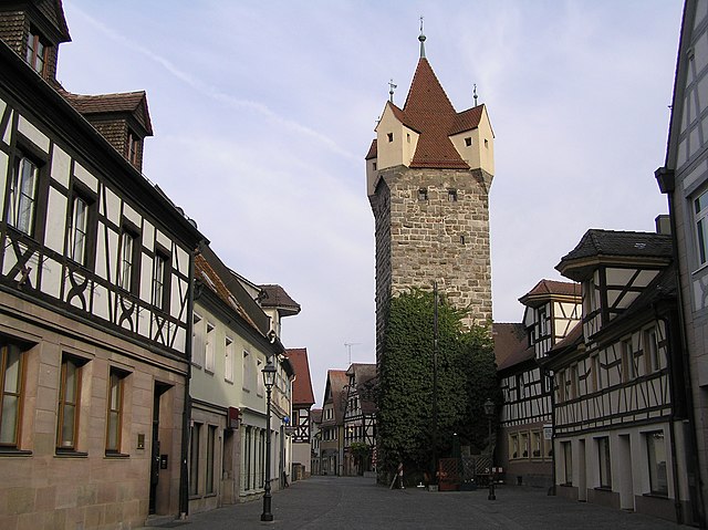
Höchstadt an der Aisch
- municipality of Germany
Hiking in Höchstadt an der Aisch
Höchstadt, a town in Bavaria, Germany, is surrounded by beautiful landscapes ideal for hiking enthusiasts. The area features a mix of trails that cater to various skill levels, whether you’re a beginner or an experienced hiker....
- Country:
- Postal Code: 91315
- Local Dialing Code: 09193
- Coordinates: 49° 42' 20" N, 10° 48' 21" E
- GPS tracks (wikiloc): [Link]
- AboveSeaLevel: 295 м m
- Area: 70.90 sq km
- Population: 13423
- Web site: [Link]


Gremsdorf
- municipality of Germany
Hiking in Gremsdorf
Gremsdorf is a small municipality in Bavaria, Germany, situated near the hand of the Franconian countryside. While it may not be as popularly known as some larger hiking destinations, it offers some charming trails and picturesque scenery for outdoor enthusiasts. Here’s what you can expect when hiking in and around Gremsdorf:...
- Country:
- Postal Code: 91350
- Local Dialing Code: 09195; 09193
- Licence Plate Code: ERH
- Coordinates: 49° 42' 0" N, 10° 49' 59" E
- GPS tracks (wikiloc): [Link]
- AboveSeaLevel: 270 м m
- Area: 12.96 sq km
- Population: 1201
- Web site: [Link]


Röttenbach
- town in the district of Erlangen-Höchstadt in Bavaria
Hiking in Röttenbach
Röttenbach is a beautiful area for hiking, located in Bavaria, Germany. It's characterized by its lovely landscapes, including rolling hills, lush forests, and scenic views. Here are some aspects to consider if you're planning a hiking trip in Röttenbach:...
- Country:
- Postal Code: 91341
- Local Dialing Code: 09195
- Licence Plate Code: HÖS; ERH
- Coordinates: 49° 40' 0" N, 10° 55' 59" E
- GPS tracks (wikiloc): [Link]
- AboveSeaLevel: 301 м m
- Area: 7.75 sq km
- Population: 3904
- Web site: [Link]


Möhrendorf
- municipality of Germany
Hiking in Möhrendorf
Möhrendorf, a quaint village located in Bavaria, Germany, offers some charming hiking opportunities, especially for those looking to explore the beautiful Franconian countryside. Here are some key points to consider when hiking in Möhrendorf:...
- Country:
- Postal Code: 91096
- Local Dialing Code: 09133; 09131
- Licence Plate Code: ERH
- Coordinates: 49° 38' 0" N, 11° 0' 0" E
- GPS tracks (wikiloc): [Link]
- AboveSeaLevel: 272 м m
- Area: 13.18 sq km
- Population: 4854
- Web site: [Link]

Heroldsberg
- municipality of Germany
Hiking in Heroldsberg
Heroldsberg, located in Bavaria, Germany, is a beautiful area for hiking, offering a mix of scenic landscapes, serene forests, and charming village paths. Here are some key points to consider if you're planning a hiking trip in Heroldsberg:...
- Country:
- Postal Code: 90562
- Local Dialing Code: 09126; 0911
- Licence Plate Code: ERH
- Coordinates: 49° 32' 0" N, 11° 9' 0" E
- GPS tracks (wikiloc): [Link]
- AboveSeaLevel: 357 м m
- Area: 11.02 sq km
- Population: 6345
- Web site: [Link]


Aurachtal
- municipality of Germany
Hiking in Aurachtal
Aurachtal, located in Bavaria, Germany, is a picturesque valley that offers a variety of hiking opportunities for outdoor enthusiasts. Here are some key highlights and tips for hiking in the Aurachtal area:...
- Country:
- Postal Code: 91086
- Local Dialing Code: 09132
- Licence Plate Code: ERH
- Coordinates: 49° 35' 0" N, 10° 50' 0" E
- GPS tracks (wikiloc): [Link]
- AboveSeaLevel: 328 м m
- Area: 18.40 sq km
- Population: 2035
- Web site: [Link]
Birkach
- unincorporated area in Germany
Hiking in Birkach
Birkach is a beautiful area in Germany, known for its natural landscapes and opportunities for outdoor activities, including hiking. While it may be less known as a significant hiking destination compared to larger parks or reserves, it offers various paths and scenic routes suitable for hikers of different skill levels....
- Country:
- Coordinates: 49° 43' 50" N, 10° 45' 30" E
- GPS tracks (wikiloc): [Link]


Buckenhofer Forst
- unincorporated area in Germany
Hiking in Buckenhofer Forst
Buckenhofer Forst is a lovely forested area located near the town of Buckenhof in Bavaria, Germany. It offers a range of hiking opportunities for outdoor enthusiasts of all experience levels. While the exact trails can vary in difficulty, the forest generally features a network of well-marked walking paths that meander through beautiful nature, making it an ideal spot for both leisurely strolls and more challenging hikes....
- Country:
- Coordinates: 49° 34' 55" N, 11° 3' 39" E
- GPS tracks (wikiloc): [Link]


Buckenhof
- municipality of Germany
Hiking in Buckenhof
Buckenhof, located in Bavaria, Germany, is a charming area that offers various opportunities for hiking enthusiasts. While it may not be a widely-known hiking destination, its proximity to the Fränkische Schweiz (Franconian Switzerland) region provides access to numerous trails with varying difficulty levels, stunning landscapes, and unique geological formations....
- Country:
- Postal Code: 91054
- Local Dialing Code: 09131
- Licence Plate Code: ERH
- Coordinates: 49° 35' 36" N, 11° 3' 2" E
- GPS tracks (wikiloc): [Link]
- AboveSeaLevel: 289 м m
- Area: 1.38 sq km
- Population: 2771
- Web site: [Link]
Shares border with regions:
Bamberg
- district in Bavaria, Germany
Hiking in Bamberg
Bamberg district, located in Bavaria, Germany, offers a variety of scenic hiking opportunities amidst its charming landscapes, historical sites, and cultural attractions. Here’s an overview of what you can expect when hiking in the region:...
- Country:
- Capital: Bamberg
- Licence Plate Code: BA
- Coordinates: 49° 49' 48" N, 10° 49' 48" E
- GPS tracks (wikiloc): [Link]
- AboveSeaLevel: 275 м m
- Area: 1168.00 sq km
- Population: 119829
- Web site: [Link]

Forchheim
- district in Bavaria, Germany
Hiking in Forchheim
Forchheim, located in Bavaria, Germany, is a charming district known for its picturesque landscapes, historical sites, and access to various hiking trails. Here’s an overview of what you can expect when hiking in this region:...
- Country:
- Licence Plate Code: PEG; FO; EBS
- Coordinates: 49° 45' 0" N, 11° 5' 0" E
- GPS tracks (wikiloc): [Link]
- AboveSeaLevel: 377 м m
- Area: 643.00 sq km
- Population: 97433
- Web site: [Link]
Nürnberger Land
- district in Bavaria, Germany
Hiking in Nürnberger Land
Nürnberger Land, located in Bavaria, Germany, is a fantastic area for hiking enthusiasts. It features a diverse landscape that includes forests, hills, and picturesque valleys, making it ideal for both casual walkers and seasoned hikers. Here are some key points about hiking in Nürnberger Land:...
- Country:
- Capital: Lauf an der Pegnitz
- Licence Plate Code: PEG; N; LAU; HEB; ESB
- Coordinates: 49° 30' 0" N, 11° 22' 0" E
- GPS tracks (wikiloc): [Link]
- AboveSeaLevel: 355 м m
- Area: 800.00 sq km
- Population: 149127
- Web site: [Link]

Fürth
- district in Bavaria, Germany
Hiking in Fürth
Fürth, located in Bavaria, Germany, offers a variety of hiking opportunities that cater to different skill levels and preferences. The area is characterized by beautiful hills, forests, and rivers, making it a great spot for outdoor enthusiasts....
- Country:
- Capital: Zirndorf
- Licence Plate Code: FÜ
- Coordinates: 49° 25' 0" N, 10° 50' 0" E
- GPS tracks (wikiloc): [Link]
- AboveSeaLevel: 397 м m
- Area: 308.00 sq km
- Population: 116193
- Web site: [Link]
Neustadt (Aisch)-Bad Windsheim
- district in Bavaria, Germany
Hiking in Neustadt (Aisch)-Bad Windsheim
Neustadt (Aisch)-Bad Windsheim, located in the Franconian region of Bavaria, Germany, offers a variety of scenic hiking opportunities for outdoor enthusiasts. The area is characterized by its picturesque landscapes, charming villages, and the rich cultural heritage of Franconia. Here are some highlights of hiking in this region:...
- Country:
- Capital: Neustadt an der Aisch
- Licence Plate Code: UFF; SEF; NEA
- Coordinates: 49° 34' 48" N, 10° 30' 0" E
- GPS tracks (wikiloc): [Link]
- AboveSeaLevel: 384 м m
- Area: 1267.54 sq km
- Population: 85686
- Web site: [Link]

Nuremberg
- city in the German state of Bavaria
Hiking in Nuremberg
Hiking in and around Nuremberg can offer a remarkable blend of urban exploration and natural beauty. Though Nuremberg itself is a city with a rich history, it is surrounded by picturesque landscapes that are perfect for hiking enthusiasts. Here are some highlights and tips for hiking in the region:...
- Country:
- Postal Code: 90402–90491
- Local Dialing Code: 0911
- Licence Plate Code: N
- Coordinates: 49° 27' 10" N, 11° 4' 40" E
- GPS tracks (wikiloc): [Link]
- AboveSeaLevel: 209 м m
- Area: 186.45 sq km
- Population: 515201
- Web site: [Link]

Erlangen
- large city in Bavaria, Germany
Hiking in Erlangen
Erlangen, located in Bavaria, Germany, is surrounded by beautiful landscapes that offer various hiking opportunities. While the city itself is relatively flat, the nearby Franconian Switzerland region and the hills of the Fichtelgebirge provide excellent trails for hikers of all skill levels....
- Country:
- Postal Code: 91001; 91058; 91057; 91056; 91055; 91054; 91053; 91052
- Local Dialing Code: 09132; 09135; 0911; 09131
- Licence Plate Code: ER
- Coordinates: 49° 35' 47" N, 11° 0' 16" E
- GPS tracks (wikiloc): [Link]
- AboveSeaLevel: 279 м m
- Area: 76900000 sq km
- Population: 108336
- Web site: [Link]