Neuvelle-lès-la-Charité (Neuvelle-lès-la-Charité)

- commune in Haute-Saône, France
- Country:

- Postal Code: 70130
- Coordinates: 47° 32' 17" N, 5° 57' 8" E


- GPS tracks (wikiloc): [Link]
- Area: 13.2 sq km
- Population: 226
- Wikipedia en: wiki(en)
- Wikipedia: wiki(fr)
- Wikidata storage: Wikidata: Q903469
- Wikipedia Commons Category: [Link]
- Freebase ID: [/m/03ntgsw]
- GeoNames ID: Alt: [6442041]
- SIREN number: [217003847]
- BnF ID: [152727769]
- PACTOLS thesaurus ID: [pcrtdBpYb40ivL]
- WOEID: [614141]
- INSEE municipality code: 70384
Shares border with regions:


Fretigney-et-Velloreille
- commune in Haute-Saône, France
- Country:
- Postal Code: 70130
- Coordinates: 47° 29' 17" N, 5° 56' 46" E
- GPS tracks (wikiloc): [Link]
- AboveSeaLevel: 241 м m
- Area: 22.02 sq km
- Population: 733
- Web site: [Link]
Bourguignon-lès-la-Charité
- commune in Haute-Saône, France
- Country:
- Postal Code: 70190
- Coordinates: 47° 30' 26" N, 5° 58' 13" E
- GPS tracks (wikiloc): [Link]
- AboveSeaLevel: 227 м m
- Area: 4.25 sq km
- Population: 123

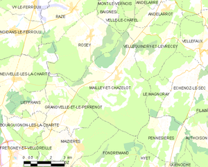
Mailley-et-Chazelot
- commune in Haute-Saône, France
- Country:
- Postal Code: 70000
- Coordinates: 47° 32' 11" N, 6° 3' 6" E
- GPS tracks (wikiloc): [Link]
- Area: 25.03 sq km
- Population: 644


Raze
- commune in Haute-Saône, France
- Country:
- Postal Code: 70000
- Coordinates: 47° 35' 1" N, 6° 0' 41" E
- GPS tracks (wikiloc): [Link]
- Area: 10.02 sq km
- Population: 346


Grandvelle-et-le-Perrenot
- commune in Haute-Saône, France
- Country:
- Postal Code: 70190
- Coordinates: 47° 30' 32" N, 5° 59' 43" E
- GPS tracks (wikiloc): [Link]
- AboveSeaLevel: 240 м m
- Area: 10.44 sq km
- Population: 358


Rosey
- commune in Haute-Saône, France
- Country:
- Postal Code: 70000
- Coordinates: 47° 33' 56" N, 6° 1' 40" E
- GPS tracks (wikiloc): [Link]
- Area: 14.64 sq km
- Population: 273

Noidans-le-Ferroux
- commune in Haute-Saône, France
- Country:
- Postal Code: 70130
- Coordinates: 47° 34' 12" N, 5° 57' 17" E
- GPS tracks (wikiloc): [Link]
- Area: 13.99 sq km
- Population: 685
- Web site: [Link]
Lieffrans
- commune in Haute-Saône, France
- Country:
- Postal Code: 70190
- Coordinates: 47° 31' 12" N, 5° 58' 17" E
- GPS tracks (wikiloc): [Link]
- Area: 4.37 sq km
- Population: 60