
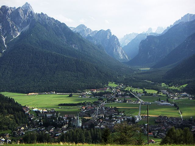
Niederdorf, South Tyrol (Villabassa)
.svg)
- Italian comune
 Hiking in Niederdorf, South Tyrol
Niederdorf, located in the beautiful South Tyrol region of northern Italy, is a charming village surrounded by picturesque landscapes, making it a great destination for hiking enthusiasts. The area offers a variety of hiking trails that cater to different skill levels, from leisurely walks to challenging hikes.
Key Highlights of Hiking in Niederdorf:
-
Scenic Trails: The trails around Niederdorf are well-marked and provide stunning views of the Dolomites, lush meadows, and forests. Depending on the season, you can experience vibrant wildflowers or beautiful autumn foliage.
-
Varied Terrain: The region features diverse terrains, including flat valley walks, steep mountain paths, and rocky trails. This variety allows hikers to choose routes that suit their fitness levels and preferences.
-
Popular Hiking Routes:
- Val di Braies (Pragser Tal): A short drive from Niederdorf, this valley offers beautiful trails around the iconic Pragser Wildsee (Pragser Lake) and up to the surrounding peaks.
- Hike to the Croda dei Toni: This trail offers breathtaking views and is popular for those seeking a moderate challenge.
- The Gaisberghütte Trail: A lovely hike leading to a mountain hut where hikers can enjoy traditional South Tyrolean cuisine.
-
Wildlife Watching: The area is home to diverse flora and fauna, including various bird species and wildlife such as deer and chamois. Keep your eyes peeled while hiking!
-
Cultural Experiences: Along the trails, you’ll have opportunities to discover local culture, including traditional farms and chapels, enhancing the overall hiking experience.
-
Seasonal Considerations: The best seasons for hiking in Niederdorf are late spring to early autumn (May to September). During these months, the weather is generally milder, and trails are accessible. Note that winter hiking requires proper gear and caution due to snow and ice.
-
Local Amenities: Niederdorf has accommodation options and facilities for visitors, including restaurants and shops where you can rest and refuel after a long day of hiking.
Tips for Hiking in Niederdorf:
- Gear Up Appropriately: Ensure you wear supportive footwear, dress in layers, and carry essentials like water, snacks, a map or GPS, and a first aid kit.
- Check Weather Conditions: The weather can change quickly in the mountains, so check forecasts before heading out.
- Stay on Marked Trails: To preserve the environment and ensure safety, stick to marked paths and trails.
- Follow Local Guidelines: Respect local regulations and wildlife, and always practice Leave No Trace principles.
Whether you’re looking for a peaceful nature walk or an adventurous trek, Niederdorf offers a rich hiking experience against the backdrop of South Tyrol’s stunning landscapes. Enjoy your hike!
- Country:

- Postal Code: 39039
- Local Dialing Code: 0474
- Licence Plate Code: BZ
- Coordinates: 46° 44' 16" N, 12° 10' 22" E


- GPS tracks (wikiloc): [Link]
- AboveSeaLevel: 1154 м m
- Area: 18.03 sq km
- Population: 1605
- Web site: http://www.gvcc.net/soci/villa_bassa.htm
- Wikipedia en: wiki(en)
- Wikipedia: wiki(it)
- Wikidata storage: Wikidata: Q504724
- Wikipedia Commons Category: [Link]
- Freebase ID: [/m/0g9k_6]
- GeoNames ID: Alt: [6535940]
- VIAF ID: Alt: [168772742]
- OSM relation ID: [47313]
- GND ID: Alt: [4042181-8]
- Library of Congress authority ID: Alt: [n85152022]
- Treccani ID: [villabassa]
- ISTAT ID: 021113
- Italian cadastre code: L915
Shares border with regions:


Prags
- Italian comune
Hiking in Prags
Prags, or Braies, is a beautiful area located in the South Tyrol region of Italy, known for its stunning natural landscapes, particularly the Dolomite Mountains. The focal point of this area is the picturesque Lago di Braies (Pragser Wildsee), a striking alpine lake surrounded by imposing peaks and lush forests....
- Country:
- Postal Code: 39030
- Local Dialing Code: 0474
- Licence Plate Code: BZ
- Coordinates: 46° 43' 0" N, 12° 8' 0" E
- GPS tracks (wikiloc): [Link]
- AboveSeaLevel: 1213 м m
- Area: 90.25 sq km
- Population: 652
- Web site: [Link]

Toblach
- Italian comune
Hiking in Toblach
Toblach, located in the South Tyrol region of northern Italy, is a beautiful destination for hikers, thanks to its stunning landscapes and well-marked trails. Here’s an overview of what you can expect when hiking in Toblach:...
- Country:
- Postal Code: 39034
- Local Dialing Code: 0474
- Licence Plate Code: BZ
- Coordinates: 46° 44' 7" N, 12° 13' 20" E
- GPS tracks (wikiloc): [Link]
- AboveSeaLevel: 1241 м m
- Area: 125.42 sq km
- Population: 3346
- Web site: [Link]


Welsberg-Taisten
- Italian comune
Hiking in Welsberg-Taisten
Welsberg-Taisten is a beautiful hiking destination located in the South Tyrol region of northern Italy. Nestled in the Dolomites, it offers a wide range of hiking trails suitable for various skill levels, from easy strolls to challenging ascents. Here are some key points about hiking in this area:...
- Country:
- Postal Code: 39035
- Local Dialing Code: 0474
- Licence Plate Code: BZ
- Coordinates: 46° 45' 28" N, 12° 6' 20" E
- GPS tracks (wikiloc): [Link]
- AboveSeaLevel: 1087 м m
- Area: 46.44 sq km
- Population: 2867
- Web site: [Link]


Gsies
- Italian comune
Hiking in Gsies
Gsies, located in the South Tyrol region of northern Italy, is a picturesque valley surrounded by the stunning Dolomites and offers a variety of hiking opportunities. Here are some highlights and tips for hiking in Gsies:...
- Country:
- Postal Code: 39035
- Local Dialing Code: 0474
- Licence Plate Code: BZ
- Coordinates: 46° 46' 6" N, 12° 10' 46" E
- GPS tracks (wikiloc): [Link]
- AboveSeaLevel: 1305 м m
- Area: 110.14 sq km
- Population: 2329
- Web site: [Link]