Nohant-en-Goût (Nohant-en-Goût)

- commune in Cher, France
- Country:

- Postal Code: 18390
- Coordinates: 47° 5' 57" N, 2° 34' 13" E


- GPS tracks (wikiloc): [Link]
- Area: 24.79 sq km
- Population: 593
- Wikipedia en: wiki(en)
- Wikipedia: wiki(fr)
- Wikidata storage: Wikidata: Q635031
- Wikipedia Commons Category: [Link]
- Freebase ID: [/m/03mfdhr]
- GeoNames ID: Alt: [6428238]
- SIREN number: [211801667]
- BnF ID: [15249512k]
- INSEE municipality code: 18166
Shares border with regions:


Sainte-Solange
- commune in Cher, France
- Country:
- Postal Code: 18220
- Coordinates: 47° 8' 11" N, 2° 33' 0" E
- GPS tracks (wikiloc): [Link]
- Area: 31.85 sq km
- Population: 1154


Osmoy
- commune in Cher, France
- Country:
- Postal Code: 18390
- Coordinates: 47° 4' 24" N, 2° 31' 22" E
- GPS tracks (wikiloc): [Link]
- Area: 22.63 sq km
- Population: 316


Savigny-en-Septaine
- commune in Cher, France
- Country:
- Postal Code: 18390
- Coordinates: 47° 2' 39" N, 2° 33' 38" E
- GPS tracks (wikiloc): [Link]
- Area: 22.58 sq km
- Population: 697

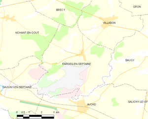
Farges-en-Septaine
- commune in Cher, France
- Country:
- Postal Code: 18800
- Coordinates: 47° 4' 24" N, 2° 39' 0" E
- GPS tracks (wikiloc): [Link]
- Area: 24.48 sq km
- Population: 1044
- Web site: [Link]

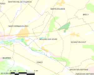
Moulins-sur-Yèvre
- commune in Cher, France
- Country:
- Postal Code: 18390
- Coordinates: 47° 4' 59" N, 2° 31' 2" E
- GPS tracks (wikiloc): [Link]
- Area: 15.33 sq km
- Population: 833

Brécy
- commune in Cher, France
- Country:
- Postal Code: 18220
- Coordinates: 47° 7' 27" N, 2° 37' 10" E
- GPS tracks (wikiloc): [Link]
- Area: 39.63 sq km
- Population: 952