canton of Baugy (canton de Baugy)
- canton of France
- Country:

- Capital: Baugy
- Coordinates: 47° 4' 59" N, 2° 43' 59" E


- GPS tracks (wikiloc): [Link]
- Wikipedia en: wiki(en)
- Wikipedia: wiki(fr)
- Wikidata storage: Wikidata: Q1657702
- Freebase ID: [/m/05synys]
- INSEE canton code: [1804]
Includes regions:


Baugy
- commune in Cher, France
- Country:
- Postal Code: 18800
- Coordinates: 47° 4' 53" N, 2° 43' 39" E
- GPS tracks (wikiloc): [Link]
- Area: 22.6 sq km
- Population: 1492


Bengy-sur-Craon
- commune in Cher, France
- Country:
- Postal Code: 18520
- Coordinates: 47° 0' 1" N, 2° 44' 52" E
- GPS tracks (wikiloc): [Link]
- Area: 35.24 sq km
- Population: 673


Crosses
- commune in Cher, France
- Country:
- Postal Code: 18340
- Coordinates: 47° 0' 39" N, 2° 34' 54" E
- GPS tracks (wikiloc): [Link]
- Area: 26.49 sq km
- Population: 380
- Web site: [Link]


Saligny-le-Vif
- commune in Cher, France
- Country:
- Postal Code: 18800
- Coordinates: 47° 2' 44" N, 2° 45' 59" E
- GPS tracks (wikiloc): [Link]
- Area: 15.29 sq km
- Population: 188


Osmoy
- commune in Cher, France
- Country:
- Postal Code: 18390
- Coordinates: 47° 4' 24" N, 2° 31' 22" E
- GPS tracks (wikiloc): [Link]
- Area: 22.63 sq km
- Population: 316
Laverdines
- commune in Cher, France
- Country:
- Postal Code: 18800
- Coordinates: 47° 1' 50" N, 2° 47' 53" E
- GPS tracks (wikiloc): [Link]
- Area: 9.89 sq km
- Population: 48


Savigny-en-Septaine
- commune in Cher, France
- Country:
- Postal Code: 18390
- Coordinates: 47° 2' 39" N, 2° 33' 38" E
- GPS tracks (wikiloc): [Link]
- Area: 22.58 sq km
- Population: 697
Jussy-Champagne
- commune in Cher, France
- Country:
- Postal Code: 18130
- Coordinates: 46° 59' 8" N, 2° 38' 38" E
- GPS tracks (wikiloc): [Link]
- Area: 27.3 sq km
- Population: 193
Vornay
- commune in Cher, France
- Country:
- Postal Code: 18130
- Coordinates: 46° 58' 23" N, 2° 35' 0" E
- GPS tracks (wikiloc): [Link]
- Area: 26.35 sq km
- Population: 597
- Web site: [Link]
Villabon
- commune in Cher, France
- Country:
- Postal Code: 18800
- Coordinates: 47° 5' 48" N, 2° 40' 29" E
- GPS tracks (wikiloc): [Link]
- Area: 18.28 sq km
- Population: 566


Gron
- commune in Cher, France
- Country:
- Postal Code: 18800
- Coordinates: 47° 7' 17" N, 2° 44' 28" E
- GPS tracks (wikiloc): [Link]
- Area: 26.22 sq km
- Population: 482
- Web site: [Link]

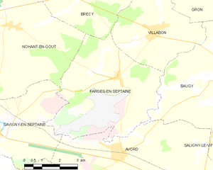
Farges-en-Septaine
- commune in Cher, France
- Country:
- Postal Code: 18800
- Coordinates: 47° 4' 24" N, 2° 39' 0" E
- GPS tracks (wikiloc): [Link]
- Area: 24.48 sq km
- Population: 1044
- Web site: [Link]

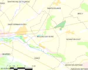
Moulins-sur-Yèvre
- commune in Cher, France
- Country:
- Postal Code: 18390
- Coordinates: 47° 4' 59" N, 2° 31' 2" E
- GPS tracks (wikiloc): [Link]
- Area: 15.33 sq km
- Population: 833
Villequiers
- commune in Cher, France
- Country:
- Postal Code: 18800
- Coordinates: 47° 4' 10" N, 2° 48' 18" E
- GPS tracks (wikiloc): [Link]
- Area: 29.49 sq km
- Population: 486
- Web site: [Link]
Nohant-en-Goût
- commune in Cher, France
- Country:
- Postal Code: 18390
- Coordinates: 47° 5' 57" N, 2° 34' 13" E
- GPS tracks (wikiloc): [Link]
- Area: 24.79 sq km
- Population: 593
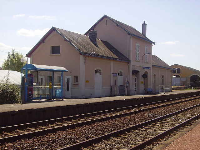
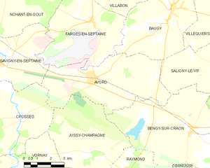
Avord
- commune in Cher, France
- Country:
- Postal Code: 18520
- Coordinates: 47° 1' 59" N, 2° 39' 12" E
- GPS tracks (wikiloc): [Link]
- Area: 27.98 sq km
- Population: 2616
- Web site: [Link]


Chassy
- commune in Cher, France
- Country:
- Postal Code: 18800
- Coordinates: 47° 2' 31" N, 2° 50' 10" E
- GPS tracks (wikiloc): [Link]
- Area: 17.76 sq km
- Population: 250