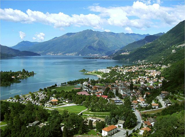
Novate Mezzola (Novate Mezzola)
.svg)
- Italian comune
 Hiking in Novate Mezzola
Novate Mezzola is a picturesque village located in the province of Sondrio, in the Lombardy region of northern Italy, near the beautiful Lake Mezzola. The surrounding area offers a range of hiking opportunities that cater to various skill levels, all set against the stunning backdrop of the Italian Alps.
Hiking Trails:
-
Sentiero del Viandante:
- This is a renowned trail that stretches along the eastern shore of Lake Como and provides beautiful views of the lake and surrounding mountains. While it doesn’t go directly through Novate Mezzola, trail access is relatively easy.
-
Val Codera:
- A beautiful hike that takes you into the Val Codera valley, known for its rugged scenery and charming traditional villages. The hike can vary in length and difficulty, offering both leisurely walks and more strenuous trails.
-
Panoramica della Val Mezzola:
- This trail offers a fantastic panoramic view of Lake Mezzola and the surrounding mountain ranges. The hike involves some elevation gain, but the vistas you will encounter are worth the effort.
-
Monte Berlinghera:
- For more experienced hikers, the ascent to Monte Berlinghera provides stunning views of both Lake Mezzola and neighboring lakes. The trail is steep and should be tackled with proper preparation and gear.
Essential Considerations:
-
Weather: Always check the weather conditions before heading out, as the mountain weather can change rapidly. Late spring to early autumn tends to be the best time for hiking.
-
Gear: Bring appropriate hiking gear, including sturdy boots, sufficient water, snacks, and possibly trekking poles for tougher trails.
-
Navigation: While many trails are marked, it’s a good idea to carry a map or have a GPS device, especially for more remote areas.
-
Local Laws: Respect local regulations, including any restrictions in protected areas and Leave No Trace principles.
-
Wildlife: The area is home to diverse flora and fauna. While hiking, keep an eye out for wildlife, but remember to observe from a distance.
Conclusion:
Hiking in and around Novate Mezzola is a rewarding experience, combining natural beauty with cultural heritage. Whether you're looking for a gentle stroll by the lake or a more challenging climb in the mountains, there's something for everyone. Always prioritize safety and preparedness, and enjoy the stunning landscapes that this region has to offer!
- Country:

- Postal Code: 23025
- Local Dialing Code: 0343
- Licence Plate Code: SO
- Coordinates: 46° 13' 0" N, 9° 27' 0" E


- GPS tracks (wikiloc): [Link]
- AboveSeaLevel: 212 м m
- Area: 99.75 sq km
- Population: 1895
- Web site: http://www.comune.novatemezzola.so.it
- Wikipedia en: wiki(en)
- Wikipedia: wiki(it)
- Wikidata storage: Wikidata: Q40183
- Wikipedia Commons Category: [Link]
- Freebase ID: [/m/0gj3dn]
- GeoNames ID: Alt: [6542054]
- VIAF ID: Alt: [234691489]
- OSM relation ID: [46988]
- UN/LOCODE: [ITNVM]
- ISTAT ID: 014046
- Italian cadastre code: F956
Shares border with regions:
Verceia
- Italian comune
Hiking in Verceia
Verceia is a picturesque village located in the Lombardy region of Italy, nestled within the stunning landscape of the Valtellina Valley near the northern shores of Lake Como. The area around Verceia offers numerous hiking opportunities, showcasing beautiful views, diverse terrain, and a chance to explore the rich natural and cultural heritage of the region....
- Country:
- Postal Code: 23020
- Local Dialing Code: 0343
- Licence Plate Code: SO
- Coordinates: 46° 12' 0" N, 9° 27' 0" E
- GPS tracks (wikiloc): [Link]
- AboveSeaLevel: 205 м m
- Area: 11.38 sq km
- Population: 1107
- Web site: [Link]


Traona
- Italian comune
Hiking in Traona
Traona is a charming village located in the Valtellina Valley of northern Italy, and it offers some beautiful hiking opportunities that cater to various skill levels. Here are some highlights about hiking in and around Traona:...
- Country:
- Postal Code: 23019
- Local Dialing Code: 0342
- Licence Plate Code: SO
- Coordinates: 46° 9' 0" N, 9° 31' 0" E
- GPS tracks (wikiloc): [Link]
- AboveSeaLevel: 252 м m
- Area: 6.37 sq km
- Population: 2782
- Web site: [Link]


Villa di Chiavenna
- Italian comune
Hiking in Villa di Chiavenna
Villa di Chiavenna, located in the province of Sondrio in Lombardy, Italy, is a charming destination for hikers and outdoor enthusiasts. Nestled in the heart of the Alps, this area offers stunning landscapes, diverse terrains, and a variety of trails suitable for different skill levels....
- Country:
- Postal Code: 23029
- Local Dialing Code: 0343
- Licence Plate Code: SO
- Coordinates: 46° 20' 0" N, 9° 29' 0" E
- GPS tracks (wikiloc): [Link]
- AboveSeaLevel: 633 м m
- Area: 32.52 sq km
- Population: 990
- Web site: [Link]
Piuro
- Italian comune
Hiking in Piuro
Piuro is a picturesque village located in the Lombardy region of northern Italy, nestled in the Seriana Valley and close to the border with Switzerland. The area is known for its stunning natural beauty, making it a great destination for hiking enthusiasts. Here are some highlights about hiking in Piuro:...
- Country:
- Postal Code: 23020
- Local Dialing Code: 0343
- Licence Plate Code: SO
- Coordinates: 46° 19' 51" N, 9° 25' 18" E
- GPS tracks (wikiloc): [Link]
- AboveSeaLevel: 382 м m
- Area: 84.25 sq km
- Population: 1932
- Web site: [Link]
Mello
- Italian comune
Hiking in Mello
Mello, located in the Lombardy region of Italy, is a beautiful destination for hiking enthusiasts. Nestled in the heart of the Sondrio province and surrounded by the lush nature of the Val Mello Valley, it offers a variety of trails that cater to different skill levels, ranging from easy walks to more challenging hikes....
- Country:
- Postal Code: 23010
- Local Dialing Code: 0342
- Licence Plate Code: SO
- Coordinates: 46° 9' 18" N, 9° 32' 50" E
- GPS tracks (wikiloc): [Link]
- AboveSeaLevel: 681 м m
- Area: 11.43 sq km
- Population: 959
- Web site: [Link]
Samolaco
- Italian comune
Hiking in Samolaco
Samolaco is a charming village located in the province of Sondrio in the Lombardy region of northern Italy. It offers a variety of hiking opportunities that showcase the stunning landscapes of the Valtellina Valley and surrounding areas....
- Country:
- Postal Code: 23027
- Local Dialing Code: 0343
- Licence Plate Code: SO
- Coordinates: 46° 16' 0" N, 9° 23' 0" E
- GPS tracks (wikiloc): [Link]
- AboveSeaLevel: 236 м m
- Area: 45.8 sq km
- Population: 2893
- Web site: [Link]
Dubino
- Italian comune
Hiking in Dubino
Dubino is a charming village in the province of Sondrio, located in the Lombardy region of northern Italy. Its picturesque setting, surrounded by mountains and lush landscapes, offers various hiking opportunities that cater to different skill levels. Here are some aspects to consider if you're planning to hike in the Dubino area:...
- Country:
- Postal Code: 23015
- Local Dialing Code: 0342
- Licence Plate Code: SO
- Coordinates: 46° 9' 0" N, 9° 27' 0" E
- GPS tracks (wikiloc): [Link]
- AboveSeaLevel: 223 м m
- Area: 13.24 sq km
- Population: 3715
- Web site: [Link]


Cercino
- Italian comune
Hiking in Cercino
Cercino, located in the mountainous region of northern Italy, offers a variety of hiking opportunities for outdoor enthusiasts. The area is characterized by its stunning landscapes, including lush forests, hills, and mountains, making it a great destination for both novice and experienced hikers....
- Country:
- Postal Code: 23016
- Local Dialing Code: 0342
- Licence Plate Code: SO
- Coordinates: 46° 9' 0" N, 9° 30' 0" E
- GPS tracks (wikiloc): [Link]
- AboveSeaLevel: 487 м m
- Area: 5.69 sq km
- Population: 760
- Web site: [Link]
Val Masino
- Italian comune
Hiking in Val Masino
Val Masino, located in the Valtellina region of northern Italy, is a stunning destination for hiking enthusiasts. Known for its dramatic landscapes, granite cliffs, lush forests, and clear rivers, Val Masino offers a variety of hiking trails suitable for different skill levels, from leisurely walks to challenging treks....
- Country:
- Postal Code: 23010
- Local Dialing Code: 0342
- Licence Plate Code: SO
- Coordinates: 46° 13' 0" N, 9° 38' 0" E
- GPS tracks (wikiloc): [Link]
- AboveSeaLevel: 787 м m
- Area: 116.71 sq km
- Population: 891
- Web site: [Link]


Civo
- Italian comune
Hiking in Civo
Civo, a charming destination in Italy, offers a range of hiking opportunities that showcase the stunning natural beauty of the region. Located in the Lombardy area near Lake Como, Civo is often less crowded than more popular hiking destinations, making it an excellent choice for those seeking tranquility in nature....
- Country:
- Postal Code: 23010
- Local Dialing Code: 0342
- Licence Plate Code: SO
- Coordinates: 46° 9' 0" N, 9° 34' 0" E
- GPS tracks (wikiloc): [Link]
- AboveSeaLevel: 719 м m
- Area: 25.14 sq km
- Population: 1115
- Web site: [Link]
Prata Camportaccio
- Italian comune
Hiking in Prata Camportaccio
Prata Camportaccio is a picturesque village located in the Valtellina region of northern Italy, surrounded by the stunning landscapes of the Italian Alps. Hiking in this area offers a unique blend of natural beauty, cultural heritage, and a variety of trails suitable for different skill levels....
- Country:
- Postal Code: 23020
- Local Dialing Code: 0343
- Licence Plate Code: SO
- Coordinates: 46° 19' 0" N, 9° 24' 0" E
- GPS tracks (wikiloc): [Link]
- AboveSeaLevel: 352 м m
- Area: 27.94 sq km
- Population: 2950
- Web site: [Link]
Cino
- Italian comune
Hiking in Cino
Cino is a picturesque area located in the Lombardy region of Italy, nestled in the Valtellina valley. Known for its stunning landscapes, rich biodiversity, and charming villages, it provides various opportunities for hiking and outdoor activities....
- Country:
- Postal Code: 23010
- Local Dialing Code: 0342
- Licence Plate Code: SO
- Coordinates: 46° 9' 0" N, 9° 29' 0" E
- GPS tracks (wikiloc): [Link]
- AboveSeaLevel: 504 м m
- Area: 5.07 sq km
- Population: 336
- Web site: [Link]

Sorico
- Italian comune
Hiking in Sorico
Sorico is a picturesque town located in the province of Sondrio, in the Lombardy region of northern Italy. It is positioned along the shores of Lake Como and offers stunning views of the surrounding mountains and lake, making it a great destination for hikers....
- Country:
- Postal Code: 22010
- Local Dialing Code: 0344
- Licence Plate Code: CO
- Coordinates: 46° 10' 20" N, 9° 22' 53" E
- GPS tracks (wikiloc): [Link]
- AboveSeaLevel: 201 м m
- Area: 24.44 sq km
- Population: 1270
- Web site: [Link]


Bregaglia
- municipality in Switzerland
Hiking in Bregaglia
Bregaglia, a stunning valley in the southern part of Switzerland, is known for its picturesque landscapes, charming villages, and a wide range of hiking opportunities. Here are some highlights about hiking in the region:...
- Country:

- Postal Code: 7603, 7605, 7606, 7608, 7610, 7516
- Local Dialing Code: 081
- Licence Plate Code: GR
- Coordinates: 46° 20' 0" N, 9° 35' 0" E
- GPS tracks (wikiloc): [Link]
- AboveSeaLevel: 994 м m
- Area: 251.45 sq km
- Population: 1531
- Web site: [Link]