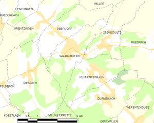
Oberdorf (Oberdorf)

- former commune in Haut-Rhin, France
 Hiking in Oberdorf
Oberdorf in the Haut-Rhin region of France is a beautiful area that offers various hiking opportunities, thanks to its scenic landscapes and proximity to the Vosges mountains. Here’s what you can expect when hiking in and around Oberdorf:
Scenic Trails
- Varied Terrain: The area boasts diverse landscapes, from rolling hills and forests to panoramic views of the Vosges mountain range. You can enjoy peaceful woodlands, vineyards, and charming Alsace villages.
- Well-Marked Paths: The trails are generally well-maintained and marked, making navigation relatively easy for hikers of all levels.
Popular Hiking Routes
- Colmar to Mulhouse Trail: This trail showcases beautiful vineyards and idyllic villages, perfect for those wanting to experience local culture alongside nature.
- Vosges Mountain Trails: For more adventurous hikers, paths leading into the Vosges mountains offer challenging routes with stunning views. Some trails may lead to higher altitudes with rewarding vistas.
Flora and Fauna
- Biodiversity: The region hosts a variety of flora and fauna, providing opportunities for nature observation. Keep an eye out for local wildlife, including deer and numerous bird species.
Tips for Hiking in Oberdorf
- Best Time to Go: Spring (April to June) and fall (September to October) are ideal for hiking due to mild weather and beautiful seasonal colors.
- Equipment: Wear sturdy hiking boots and bring plenty of water and snacks. A hiking map or a smartphone with GPS can be helpful for navigation.
- Local Amenities: Oberdorf and nearby villages have cafes and restaurants where you can enjoy local Alsace cuisine after a day of hiking.
Local Culture
- Fairy Tale Villages: Don't miss exploring nearby picturesque villages such as Eguisheim and Turckheim, which add a cultural dimension to your hiking experience.
Before heading out, it's always good to check local hiking guides, consult maps, and be aware of the current weather conditions. Enjoy your hiking adventure in Oberdorf!
- Country:

- Postal Code: 68960
- Coordinates: 47° 33' 32" N, 7° 18' 27" E


- GPS tracks (wikiloc): [Link]
- Area: 4.13 sq km
- Population: 598
- Wikipedia en: wiki(en)
- Wikipedia: wiki(fr)
- Wikidata storage: Wikidata: Q148123
- Wikipedia Commons Category: [Link]
- Freebase ID: [/m/03nstg0]
- Freebase ID: [/m/03nstg0]
- GeoNames ID: Alt: [6613957]
- GeoNames ID: Alt: [6613957]
- BnF ID: [152719429]
- BnF ID: [152719429]
- INSEE municipality code: 68240
- INSEE municipality code: 68240
Shares border with regions:


Riespach
- commune in Haut-Rhin, France
Hiking in Riespach
Riespach is a small region in the Vosges mountains of France, known for its picturesque landscapes and outdoor activities, including hiking. Here are some key points to consider if you plan to hike in Riespach:...
- Country:
- Postal Code: 68640
- Coordinates: 47° 32' 26" N, 7° 17' 15" E
- GPS tracks (wikiloc): [Link]
- Area: 7.57 sq km
- Population: 686


Grentzingen
- former commune in Haut-Rhin, France
Hiking in Grentzingen
Grentzingen is a small village located in the Alsace region of France, near the border with Germany. While Grentzingen itself may not be the most famous hiking destination, its proximity to the Vosges mountains and the beautiful Alsace countryside offers some excellent hiking opportunities....
- Country:
- Postal Code: 68960
- Coordinates: 47° 33' 55" N, 7° 17' 56" E
- GPS tracks (wikiloc): [Link]
- Area: 5.18 sq km
- Population: 568

Waldighofen
- commune in Haut-Rhin, France
Hiking in Waldighofen
Waldighofen is a charming village located in the Alsace region of France, known for its picturesque landscapes and outdoor activities, including hiking. When hiking in Waldighofen, you can expect scenic views, a mix of forests, fields, and vineyards, as well as a mild climate suitable for year-round exploration....
- Country:
- Postal Code: 68640
- Coordinates: 47° 33' 3" N, 7° 19' 0" E
- GPS tracks (wikiloc): [Link]
- Area: 4.14 sq km
- Population: 1544
- Web site: [Link]


Willer
- commune in Haut-Rhin, France
Hiking in Willer
Willer, a small community nestled in a scenic area, offers a variety of hiking opportunities that cater to different skill levels. While specific trails and conditions may vary, here are some key points to consider for hiking in or around Willer:...
- Country:
- Postal Code: 68960
- Coordinates: 47° 35' 9" N, 7° 19' 11" E
- GPS tracks (wikiloc): [Link]
- Area: 6.21 sq km
- Population: 324


Steinsoultz
- commune in Haut-Rhin, France
Hiking in Steinsoultz
Steinsoultz, located in the Alsace region of France near the Vosges mountains, offers a picturesque setting for hiking enthusiasts. The region is known for its stunning landscapes, charming villages, and diverse trails that cater to various skill levels....
- Country:
- Postal Code: 68640
- Coordinates: 47° 33' 14" N, 7° 20' 15" E
- GPS tracks (wikiloc): [Link]
- Area: 4.06 sq km
- Population: 788