Oberhoffen-sur-Moder (Oberhoffen-sur-Moder)

- commune in Bas-Rhin, France
- Country:

- Postal Code: 67240
- Coordinates: 48° 47' 2" N, 7° 51' 49" E


- GPS tracks (wikiloc): [Link]
- Area: 14.25 sq km
- Population: 3441
- Web site: http://www.ville-oberhoffen.fr
- Wikipedia en: wiki(en)
- Wikipedia: wiki(fr)
- Wikidata storage: Wikidata: Q21454
- Wikipedia Commons Category: [Link]
- Freebase ID: [/m/03m3w4j]
- Freebase ID: [/m/03m3w4j]
- GeoNames ID: Alt: [6441263]
- GeoNames ID: Alt: [6441263]
- SIREN number: [216703454]
- SIREN number: [216703454]
- BnF ID: [15271487w]
- BnF ID: [15271487w]
- VIAF ID: Alt: [247402139]
- VIAF ID: Alt: [247402139]
- PACTOLS thesaurus ID: [pcrtPPh5nuxHBh]
- PACTOLS thesaurus ID: [pcrtPPh5nuxHBh]
- SUDOC authorities ID: [067081371]
- SUDOC authorities ID: [067081371]
- INSEE municipality code: 67345
- INSEE municipality code: 67345
Shares border with regions:


Rohrwiller
- commune in Bas-Rhin, France
- Country:
- Postal Code: 67410
- Coordinates: 48° 45' 20" N, 7° 54' 19" E
- GPS tracks (wikiloc): [Link]
- Area: 2.95 sq km
- Population: 1689

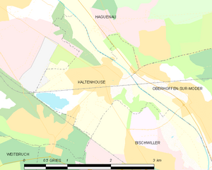
Kaltenhouse
- commune in Bas-Rhin, France
- Country:
- Postal Code: 67240
- Coordinates: 48° 47' 27" N, 7° 49' 55" E
- GPS tracks (wikiloc): [Link]
- Area: 3.72 sq km
- Population: 2131
- Web site: [Link]

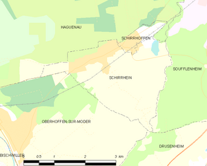
Schirrhein
- commune in Bas-Rhin, France
- Country:
- Postal Code: 67240
- Coordinates: 48° 48' 5" N, 7° 54' 22" E
- GPS tracks (wikiloc): [Link]
- Area: 6.49 sq km
- Population: 2207


Bischwiller
- commune in Bas-Rhin, France
- Country:
- Postal Code: 67240
- Coordinates: 48° 45' 59" N, 7° 51' 25" E
- GPS tracks (wikiloc): [Link]
- Area: 17.25 sq km
- Population: 12579
- Web site: [Link]

Haguenau
- commune in Bas-Rhin, France
- Country:
- Postal Code: 67500
- Coordinates: 48° 49' 0" N, 7° 47' 16" E
- GPS tracks (wikiloc): [Link]
- AboveSeaLevel: 150 м m
- Area: 182.59 sq km
- Population: 34846
- Web site: [Link]


Drusenheim
- commune in Bas-Rhin, France
- Country:
- Postal Code: 67410
- Coordinates: 48° 45' 43" N, 7° 57' 6" E
- GPS tracks (wikiloc): [Link]
- Area: 15.73 sq km
- Population: 5102
- Web site: [Link]