.jpg)
Haguenau (Haguenau)

- commune in Bas-Rhin, France
- Country:

- Postal Code: 67500
- Coordinates: 48° 49' 0" N, 7° 47' 16" E


- GPS tracks (wikiloc): [Link]
- AboveSeaLevel: 150 м m
- Area: 182.59 sq km
- Population: 34846
- Web site: http://www.ville-haguenau.fr
- Wikipedia en: wiki(en)
- Wikipedia: wiki(fr)
- Wikidata storage: Wikidata: Q22730
- Wikipedia Commons Gallery: [Link]
- Wikipedia Commons Category: [Link]
- Wikipedia Commons Maps Category: [Link]
- Freebase ID: [/m/03x_c6]
- Freebase ID: [/m/03x_c6]
- GeoNames ID: Alt: [3014078]
- GeoNames ID: Alt: [3014078]
- SIREN number: [216701805]
- SIREN number: [216701805]
- BnF ID: [152713221]
- BnF ID: [152713221]
- VIAF ID: Alt: [153028485]
- VIAF ID: Alt: [153028485]
- OSM relation ID: [89859]
- OSM relation ID: [89859]
- GND ID: Alt: [4094465-7]
- GND ID: Alt: [4094465-7]
- archINFORM location ID: [7215]
- archINFORM location ID: [7215]
- Library of Congress authority ID: Alt: [n84155015]
- Library of Congress authority ID: Alt: [n84155015]
- PACTOLS thesaurus ID: [pcrt01abL0blcu]
- PACTOLS thesaurus ID: [pcrt01abL0blcu]
- MusicBrainz area ID: [01998114-23d7-4169-bee1-4faddcb2fd70]
- MusicBrainz area ID: [01998114-23d7-4169-bee1-4faddcb2fd70]
- Quora topic ID: [Haguenau-France]
- Quora topic ID: [Haguenau-France]
- Encyclopædia Britannica Online ID: [place/Haguenau]
- Encyclopædia Britannica Online ID: [place/Haguenau]
- Encyclopædia Universalis ID: [haguenau]
- Encyclopædia Universalis ID: [haguenau]
- Twitter username: Alt: [VilledeHaguenau]
- Twitter username: Alt: [VilledeHaguenau]
- AAT ID: [300106326]
- AAT ID: [300106326]
- INSEE municipality code: 67180
- INSEE municipality code: 67180
Shares border with regions:


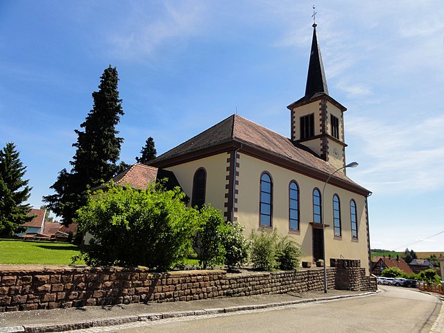
Bitschhoffen
- commune in Bas-Rhin, France
- Country:
- Postal Code: 67350
- Coordinates: 48° 51' 33" N, 7° 37' 12" E
- GPS tracks (wikiloc): [Link]
- Area: 2.54 sq km
- Population: 445


Dauendorf
- commune in Bas-Rhin, France
- Country:
- Postal Code: 67350
- Coordinates: 48° 49' 49" N, 7° 39' 19" E
- GPS tracks (wikiloc): [Link]
- Area: 7.63 sq km
- Population: 1448
Batzendorf
- commune in Bas-Rhin, France
- Country:
- Postal Code: 67500
- Coordinates: 48° 47' 1" N, 7° 42' 20" E
- GPS tracks (wikiloc): [Link]
- Area: 6.74 sq km
- Population: 992
- Web site: [Link]


Biblisheim
- commune in Bas-Rhin, France
- Country:
- Postal Code: 67360
- Coordinates: 48° 53' 56" N, 7° 47' 42" E
- GPS tracks (wikiloc): [Link]
- AboveSeaLevel: 155 м m
- Area: 2.24 sq km
- Population: 343
Forstheim
- commune in Bas-Rhin, France
- Country:
- Postal Code: 67580
- Coordinates: 48° 53' 50" N, 7° 42' 51" E
- GPS tracks (wikiloc): [Link]
- Area: 5.05 sq km
- Population: 574
- Web site: [Link]


Niederschaeffolsheim
- commune in Bas-Rhin, France
- Country:
- Postal Code: 67500
- Coordinates: 48° 46' 20" N, 7° 44' 18" E
- GPS tracks (wikiloc): [Link]
- Area: 6.24 sq km
- Population: 1375

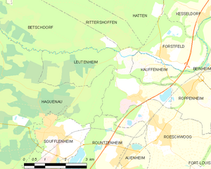
Leutenheim
- commune in Bas-Rhin, France
- Country:
- Postal Code: 67480
- Coordinates: 48° 50' 34" N, 8° 1' 15" E
- GPS tracks (wikiloc): [Link]
- Area: 10.39 sq km
- Population: 849
- Web site: [Link]
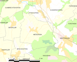
Mietesheim
- commune in Bas-Rhin, France
- Country:
- Postal Code: 67580
- Coordinates: 48° 52' 41" N, 7° 38' 29" E
- GPS tracks (wikiloc): [Link]
- Area: 8.49 sq km
- Population: 669
Laubach
- commune in Bas-Rhin, France
- Country:
- Postal Code: 67580
- Coordinates: 48° 52' 54" N, 7° 43' 13" E
- GPS tracks (wikiloc): [Link]
- Area: 1.69 sq km
- Population: 317

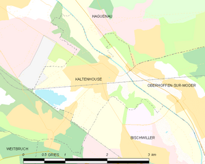
Kaltenhouse
- commune in Bas-Rhin, France
- Country:
- Postal Code: 67240
- Coordinates: 48° 47' 27" N, 7° 49' 55" E
- GPS tracks (wikiloc): [Link]
- Area: 3.72 sq km
- Population: 2131
- Web site: [Link]


Niedermodern
- commune in Bas-Rhin, France
- Country:
- Postal Code: 67350
- Coordinates: 48° 50' 43" N, 7° 37' 34" E
- GPS tracks (wikiloc): [Link]
- AboveSeaLevel: 209.5 м m
- Area: 4.39 sq km
- Population: 917
- Web site: [Link]

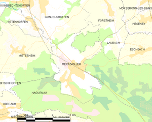
Mertzwiller
- commune in Bas-Rhin, France
- Country:
- Postal Code: 67580
- Coordinates: 48° 51' 47" N, 7° 40' 47" E
- GPS tracks (wikiloc): [Link]
- Area: 6.96 sq km
- Population: 3371
- Web site: [Link]


Oberhoffen-sur-Moder
- commune in Bas-Rhin, France
- Country:
- Postal Code: 67240
- Coordinates: 48° 47' 2" N, 7° 51' 49" E
- GPS tracks (wikiloc): [Link]
- Area: 14.25 sq km
- Population: 3441
- Web site: [Link]


Rountzenheim
- commune in Bas-Rhin, France
- Country:
- Postal Code: 67480
- Coordinates: 48° 49' 9" N, 8° 0' 23" E
- GPS tracks (wikiloc): [Link]
- Area: 6.67 sq km
- Population: 1043
- Web site: [Link]
Eschbach
- commune in Bas-Rhin, France
- Country:
- Postal Code: 67360
- Coordinates: 48° 52' 27" N, 7° 44' 11" E
- GPS tracks (wikiloc): [Link]
- Area: 3.97 sq km
- Population: 929

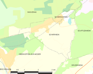
Schirrhein
- commune in Bas-Rhin, France
- Country:
- Postal Code: 67240
- Coordinates: 48° 48' 5" N, 7° 54' 22" E
- GPS tracks (wikiloc): [Link]
- Area: 6.49 sq km
- Population: 2207


Surbourg
- commune in Bas-Rhin, France
- Country:
- Postal Code: 67250
- Coordinates: 48° 54' 32" N, 7° 50' 52" E
- GPS tracks (wikiloc): [Link]
- Area: 10.46 sq km
- Population: 1667


Schirrhoffen
- commune in Bas-Rhin, France
- Country:
- Postal Code: 67240
- Coordinates: 48° 48' 22" N, 7° 55' 19" E
- GPS tracks (wikiloc): [Link]
- Area: 0.63 sq km
- Population: 707


Walbourg
- commune in Bas-Rhin, France
- Country:
- Postal Code: 67360
- Coordinates: 48° 53' 12" N, 7° 47' 22" E
- GPS tracks (wikiloc): [Link]
- Area: 5.33 sq km
- Population: 881
- Web site: [Link]


Betschdorf
- commune in Bas-Rhin, France
- Country:
- Postal Code: 67660
- Coordinates: 48° 53' 55" N, 7° 54' 21" E
- GPS tracks (wikiloc): [Link]
- Area: 28.11 sq km
- Population: 4113
- Web site: [Link]


Schweighouse-sur-Moder
- commune in Bas-Rhin, France
- Country:
- Postal Code: 67590
- Coordinates: 48° 49' 9" N, 7° 43' 41" E
- GPS tracks (wikiloc): [Link]
- AboveSeaLevel: 158 м m
- Area: 9.91 sq km
- Population: 4891
- Web site: [Link]


Uberach
- former commune in Bas-Rhin, France
- Country:
- Postal Code: 67350
- Coordinates: 48° 50' 58" N, 7° 37' 43" E
- GPS tracks (wikiloc): [Link]
- Area: 2.01 sq km
- Population: 1166
- Web site: [Link]


Bischwiller
- commune in Bas-Rhin, France
- Country:
- Postal Code: 67240
- Coordinates: 48° 45' 59" N, 7° 51' 25" E
- GPS tracks (wikiloc): [Link]
- Area: 17.25 sq km
- Population: 12579
- Web site: [Link]


Soufflenheim
- commune in Bas-Rhin, France
- Country:
- Postal Code: 67620
- Coordinates: 48° 49' 47" N, 7° 57' 47" E
- GPS tracks (wikiloc): [Link]
- AboveSeaLevel: 138 м m
- Area: 13.24 sq km
- Population: 4943
- Web site: [Link]


Gries
- commune in Bas-Rhin, France
- Country:
- Postal Code: 67240
- Coordinates: 48° 45' 17" N, 7° 48' 59" E
- GPS tracks (wikiloc): [Link]
- Area: 12.23 sq km
- Population: 2747
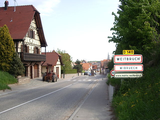
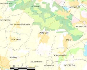
Weitbruch
- commune in Bas-Rhin, France
- Country:
- Postal Code: 67500
- Coordinates: 48° 45' 23" N, 7° 46' 40" E
- GPS tracks (wikiloc): [Link]
- Area: 15.11 sq km
- Population: 2848
- Web site: [Link]