Oberrüti (Oberrüti)

- municipality in Switzerland
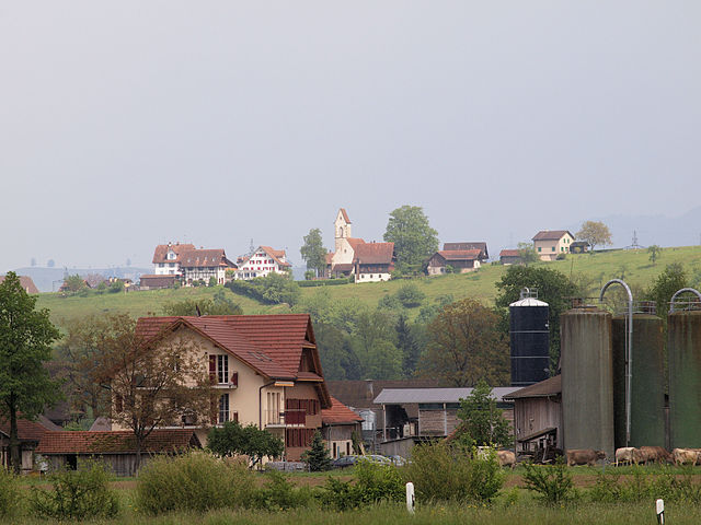
 Hiking in Oberrüti
Oberrüti, located in the Canton of Aargau in Switzerland, is a charming destination for hiking enthusiasts. The region offers beautiful landscapes, including rolling hills, lush forests, and scenic views of the surrounding mountains. Here are some highlights about hiking in Oberrüti:
Trails and Terrain
- Variety of Trails: Oberrüti has a range of hiking trails suitable for different fitness levels, from easy walks to more challenging hikes.
- Well-Marked Routes: The trails are well-marked and maintained, making it easy to navigate. Look for the yellow hiking signs indicating various routes.
- Panoramic Views: Many trails provide stunning views of the Swiss Alps and the scenic Aargau region.
Nature and Scenery
- Flora and Fauna: The area is rich in biodiversity, with lush greenery and various species of birds and animals. It's an excellent place for nature lovers and photographers.
- Cultural Landmarks: Some trails may lead to historical sites or viewpoints that offer insight into the local culture and history.
Accessibility
- Public Transport: Oberrüti is accessible by public transportation, making it convenient for hikers to reach the starting points of different trails.
- Family-Friendly: Many trails are suitable for families, making it an ideal spot for a day trip with children.
Tips for Hiking in Oberrüti
- Weather Awareness: Always check the weather forecast before heading out, as conditions can change rapidly in the mountains.
- Appropriate Gear: Wear suitable hiking boots and bring plenty of water, snacks, and a map or GPS device.
- Leave No Trace: Follow Leave No Trace principles to keep the area clean and preserve its natural beauty.
Local Amenities
- Food and Accommodation: There are local eateries where you can enjoy a meal or refreshment after your hike, and options for accommodation if you choose to extend your stay.
Whether you're a seasoned hiker or just looking for a pleasant walk in nature, Oberrüti can offer a refreshing escape into the great outdoors.
- Country:

- Postal Code: 5647
- Local Dialing Code: 041
- Licence Plate Code: AG
- Coordinates: 47° 10' 1" N, 8° 23' 55" E


- GPS tracks (wikiloc): [Link]
- AboveSeaLevel: 416 м m
- Area: 5.37 sq km
- Population: 1573
- Web site: http://www.oberrueti.ch
- Wikipedia en: wiki(en)
- Wikipedia: wiki(de)
- Wikidata storage: Wikidata: Q64771
- Wikipedia Commons Category: [Link]
- Freebase ID: [/m/0flr_v]
- GeoNames ID: Alt: [7286711]
- VIAF ID: Alt: [241238849]
- OSM relation ID: [1684391]
- HDS ID: [1792]
- Swiss municipality code: [4237]
Shares border with regions:


Sins
- municipality in Switzerland
Hiking in Sins
Sins, located in the canton of Aargau in Switzerland, is a charming village that serves as a great starting point for hiking enthusiasts. The surrounding region is characterized by rolling hills, lush meadows, and forests, providing a variety of trails that cater to different skill levels....
- Country:
- Postal Code: 5643
- Local Dialing Code: 041
- Licence Plate Code: AG
- Coordinates: 47° 11' 29" N, 8° 23' 49" E
- GPS tracks (wikiloc): [Link]
- AboveSeaLevel: 410 м m
- Area: 20.28 sq km
- Population: 4315
- Web site: [Link]


Dietwil
- municipality in Switzerland
Hiking in Dietwil
Dietwil, a charming village in the canton of Aargau, Switzerland, is surrounded by beautiful landscapes that offer a variety of hiking opportunities. Here’s what you can expect when hiking in and around Dietwil:...
- Country:
- Postal Code: 6042
- Local Dialing Code: 041
- Licence Plate Code: AG
- Coordinates: 47° 8' 52" N, 8° 23' 42" E
- GPS tracks (wikiloc): [Link]
- AboveSeaLevel: 413 м m
- Area: 5.49 sq km
- Population: 1325
- Web site: [Link]
Hünenberg
- municipality in Switzerland
Hiking in Hünenberg
Hünenberg, located in the Canton of Zug in Switzerland, offers a blend of beautiful landscapes, scenic views, and various hiking opportunities. Here are some key points to consider if you’re planning a hike in this area:...
- Country:
- Postal Code: 6331
- Local Dialing Code: 041
- Licence Plate Code: ZG
- Coordinates: 47° 11' 29" N, 8° 25' 11" E
- GPS tracks (wikiloc): [Link]
- AboveSeaLevel: 403 м m
- Area: 18.7 sq km
- Population: 8824
- Web site: [Link]