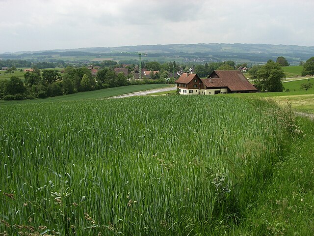
Hünenberg (Hünenberg)

- municipality in Switzerland
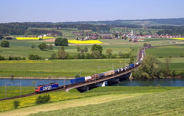
 Hiking in Hünenberg
Hünenberg, located in the Canton of Zug in Switzerland, offers a blend of beautiful landscapes, scenic views, and various hiking opportunities. Here are some key points to consider if you’re planning a hike in this area:
Trails and Routes
-
Hiking Trails: Hünenberg features a network of well-marked trails suitable for different skill levels. You can find both short, leisurely walks and longer, more demanding hikes. The trails often lead through forests, past local farms, and offer lovely views of the surrounding Zurich and Zug lakes.
-
Zug Mountains: The nearby Zug Mountains provide fantastic hiking options with varying elevations. You can enjoy panoramic views of the Alps on clear days.
-
Local Highlights: Some popular spots include the trails around the area of the Hünenberg See and the nearby nature reserves, where you might encounter local wildlife.
Difficulty Levels
- Easy: Flat and well-maintained trails perfect for families, such as around Hünenberg Lake.
- Moderate: Trails that might include some elevation gain and rocky sections, suitable for those with some hiking experience.
- Challenging: Routes that may require good fitness levels and experience, particularly in the Zug Mountains.
Best Time to Hike
- Spring and Fall: These seasons generally offer the best weather for hiking, with blooming flora and beautiful autumn colors.
- Summer: You can still enjoy hiking, but be prepared for warmer temperatures.
Safety and Preparation
- Always check the weather before heading out.
- Wear appropriate footwear and clothing for hiking, and consider bringing trekking poles if you are tackling steeper trails.
- Bring water, snacks, and a first-aid kit for your hike.
- Make sure to inform someone about your hiking plans.
Accessibility
Hünenberg is relatively accessible by public transport, making it easy for hikers from surrounding regions to explore.
Local Amenities
After your hike, consider visiting local cafes or restaurants to enjoy Swiss cuisine and possibly local specialties from the Zug region.
Remember, whether you're a novice or an experienced hiker, hiking in Hünenberg can provide a great experience in nature, offering the chance to enjoy the stunning Swiss landscape. Make sure to tread lightly and respect the natural environment during your hikes!
- Country:

- Postal Code: 6331
- Local Dialing Code: 041
- Licence Plate Code: ZG
- Coordinates: 47° 11' 29" N, 8° 25' 11" E


- GPS tracks (wikiloc): [Link]
- AboveSeaLevel: 403 м m
- Area: 18.7 sq km
- Population: 8824
- Web site: http://www.huenenberg.ch
- Wikipedia en: wiki(en)
- Wikipedia: wiki(de)
- Wikidata storage: Wikidata: Q66256
- Wikipedia Commons Category: [Link]
- Freebase ID: [/m/0fwln0]
- GeoNames ID: Alt: [7286121]
- VIAF ID: Alt: [233642055]
- OSM relation ID: [1683143]
- archINFORM location ID: [10163]
- HDS ID: [789]
- Swiss municipality code: [1703]
Shares border with regions:


Mühlau
- municipality in the canton Aargau, Switzerland
Hiking in Mühlau
Mühlau is a picturesque area located in Austria, near Innsbruck, that offers several hiking opportunities for outdoor enthusiasts. Nestled among the Alps, it provides stunning views, diverse flora and fauna, and various trails suitable for hikers of all skill levels....
- Country:
- Postal Code: 5642
- Local Dialing Code: 056
- Licence Plate Code: AG
- Coordinates: 47° 13' 49" N, 8° 23' 30" E
- GPS tracks (wikiloc): [Link]
- AboveSeaLevel: 397 м m
- Area: 5.52 sq km
- Population: 1172
- Web site: [Link]


Merenschwand
- municipality in Switzerland
Hiking in Merenschwand
Merenschwand, a picturesque municipality located in the Canton of Aargau in Switzerland, offers a variety of hiking opportunities that cater to different skill levels. Nestled in a beautiful landscape characterized by rolling hills, forests, and stunning views of the surrounding countryside, it's an excellent destination for both casual walkers and more experienced hikers....
- Country:
- Postal Code: 5634
- Local Dialing Code: 056
- Licence Plate Code: AG
- Coordinates: 47° 15' 44" N, 8° 22' 39" E
- GPS tracks (wikiloc): [Link]
- AboveSeaLevel: 381 м m
- Area: 13.51 sq km
- Population: 3393
- Web site: [Link]


Dietwil
- municipality in Switzerland
Hiking in Dietwil
Dietwil, a charming village in the canton of Aargau, Switzerland, is surrounded by beautiful landscapes that offer a variety of hiking opportunities. Here’s what you can expect when hiking in and around Dietwil:...
- Country:
- Postal Code: 6042
- Local Dialing Code: 041
- Licence Plate Code: AG
- Coordinates: 47° 8' 52" N, 8° 23' 42" E
- GPS tracks (wikiloc): [Link]
- AboveSeaLevel: 413 м m
- Area: 5.49 sq km
- Population: 1325
- Web site: [Link]

Oberrüti
- municipality in Switzerland
Hiking in Oberrüti
Oberrüti, located in the Canton of Aargau in Switzerland, is a charming destination for hiking enthusiasts. The region offers beautiful landscapes, including rolling hills, lush forests, and scenic views of the surrounding mountains. Here are some highlights about hiking in Oberrüti:...
- Country:
- Postal Code: 5647
- Local Dialing Code: 041
- Licence Plate Code: AG
- Coordinates: 47° 10' 1" N, 8° 23' 55" E
- GPS tracks (wikiloc): [Link]
- AboveSeaLevel: 416 м m
- Area: 5.37 sq km
- Population: 1573
- Web site: [Link]

Maschwanden
- municipality in Switzerland
Hiking in Maschwanden
Maschwanden is a picturesque village located near Zug in Switzerland, surrounded by beautiful natural landscapes that are ideal for hiking. The area offers several trails suitable for various skill levels, making it a great destination for both novice and experienced hikers....
- Country:
- Postal Code: 8933
- Local Dialing Code: 044
- Licence Plate Code: ZH
- Coordinates: 47° 14' 5" N, 8° 25' 45" E
- GPS tracks (wikiloc): [Link]
- AboveSeaLevel: 407 м m
- Area: 4.67 sq km
- Population: 641
- Web site: [Link]


Obfelden
- municipality in Switzerland
Hiking in Obfelden
Obfelden, located in the Canton of Zurich, Switzerland, offers beautiful hiking opportunities amidst stunning natural landscapes. The region is characterized by rolling hills, lush forests, and picturesque views of the surrounding Alps, making it a great destination for hikers of all skill levels....
- Country:
- Postal Code: 8912
- Local Dialing Code: 044
- Licence Plate Code: ZH
- Coordinates: 47° 15' 42" N, 8° 25' 19" E
- GPS tracks (wikiloc): [Link]
- AboveSeaLevel: 435 м m
- Area: 7.54 sq km
- Population: 5340
- Web site: [Link]


Zug
- city in Switzerland, capital of its canton
Hiking in Zug
Hiking in Zug, Switzerland, offers a wonderful blend of scenic beauty, varied terrain, and accessible trails, making it an ideal destination for both casual walkers and experienced hikers. Here are some key highlights about hiking in the area:...
- Country:
- Postal Code: 6317; 6305; 6300; 6310; 6300–6305
- Local Dialing Code: 041
- Licence Plate Code: ZG
- Coordinates: 47° 10' 9" N, 8° 30' 59" E
- GPS tracks (wikiloc): [Link]
- AboveSeaLevel: 611 м m
- Area: 21.61 sq km
- Population: 30205
- Web site: [Link]

Cham
- municipality in Switzerland
Hiking in Cham
Hiking in Cham, Switzerland, offers a beautiful blend of scenic views, diverse trails, and rich cultural experiences. Located in the Zug region, Cham lies along the shores of Lake Zug and is surrounded by stunning countryside and mountains. Here are some highlights and tips for hiking in this area:...
- Country:
- Postal Code: 6330
- Local Dialing Code: 041
- Licence Plate Code: ZG
- Coordinates: 47° 10' 49" N, 8° 27' 34" E
- GPS tracks (wikiloc): [Link]
- AboveSeaLevel: 420 м m
- Area: 19.82 sq km
- Population: 16690
- Web site: [Link]