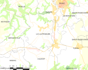
Olemps (Olemps)

- commune in Aveyron, France
- Country:

- Postal Code: 12510
- Coordinates: 44° 20' 46" N, 2° 33' 10" E


- GPS tracks (wikiloc): [Link]
- Area: 12.79 sq km
- Population: 3359
- Web site: http://www.mairie-olemps.fr
- Wikipedia en: wiki(en)
- Wikipedia: wiki(fr)
- Wikidata storage: Wikidata: Q1406179
- Wikipedia Commons Category: [Link]
- Freebase ID: [/m/03m94v1]
- GeoNames ID: Alt: [2989629]
- SIREN number: [211201744]
- BnF ID: [15247150j]
- INSEE municipality code: 12174
Shares border with regions:


Flavin
- commune in Aveyron, France
- Country:
- Postal Code: 12450
- Coordinates: 44° 17' 20" N, 2° 36' 22" E
- GPS tracks (wikiloc): [Link]
- Area: 50.77 sq km
- Population: 2308
- Web site: [Link]


Druelle
- former commune in Aveyron, France
- Country:
- Postal Code: 12510
- Coordinates: 44° 20' 40" N, 2° 29' 35" E
- GPS tracks (wikiloc): [Link]
- Area: 35.68 sq km
- Population: 2388
- Web site: [Link]


Le Monastère
- commune in Aveyron, France
- Country:
- Postal Code: 12000
- Coordinates: 44° 20' 34" N, 2° 34' 42" E
- GPS tracks (wikiloc): [Link]
- Area: 6.73 sq km
- Population: 2185
- Web site: [Link]


Rodez
- commune in Aveyron, France
- Country:
- Postal Code: 12000
- Coordinates: 44° 21' 0" N, 2° 34' 27" E
- GPS tracks (wikiloc): [Link]
- AboveSeaLevel: 640 м m
- Area: 11.18 sq km
- Population: 23949
- Web site: [Link]

Luc-la-Primaube
- commune in Aveyron, France
- Country:
- Postal Code: 12450
- Coordinates: 44° 18' 50" N, 2° 32' 6" E
- GPS tracks (wikiloc): [Link]
- Area: 26.85 sq km
- Population: 5918
- Web site: [Link]