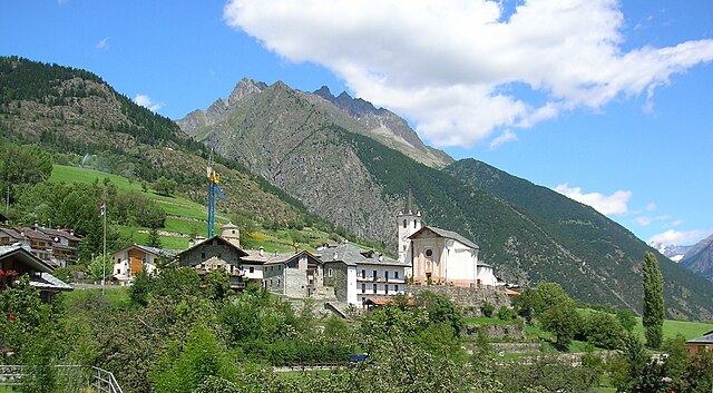
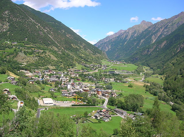
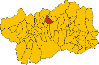
Ollomont (Ollomont)
.svg)
- Italian comune
 Hiking in Ollomont
Ollomont is a charming municipality located in the Aosta Valley region of Italy, known for its stunning natural landscapes and outdoor recreational opportunities, including hiking. Here are some insights into hiking in Ollomont:
Scenic Trails
-
Panoramic Views: The trails in Ollomont offer breathtaking views of the surrounding mountains, valleys, and local flora and fauna. The region is characterized by its picturesque landscapes, including alpine meadows, forests, and rugged peaks.
-
Diverse Difficulty Levels: There are hiking trails suitable for a range of abilities, from easy walks to more challenging hikes. This makes it accessible for families, casual hikers, and experienced trekkers alike.
-
Popular Routes:
- Col d’Olen: A popular hike that provides incredible views of the surrounding mountain ranges and a chance to immerse yourself in nature.
- Sentiero della Crotta: This trail takes you through stunning natural landscapes and is a great option for those looking to experience the local environment more intimately.
Local Nature and Wildlife
Ollomont is home to a range of biodiversity, and hikers may encounter various alpine plants and wildlife, including ibex and chamois. Keep an eye out for unique flora along the trails, particularly during the blooming season in spring and early summer.
Accessibility and Recommendations
- Best Time to Hike: The hiking season typically runs from late spring to early autumn, depending on snow levels in the mountains. Summer months are particularly popular due to the mild weather and long daylight hours.
- Gear: Proper hiking gear is essential, including comfortable footwear, weather-appropriate clothing, and sufficient water and snacks. Some trails may require more technical gear, so be sure to check the specific trail requirements.
Local Amenities
Ollomont offers various local amenities such as guesthouses and restaurants where you can relax after a day of hiking. It’s a great opportunity to try some regional cuisine and recharge for your next adventure.
Safety Tips
- Always check the weather before heading out, as conditions in the mountains can change rapidly.
- Inform someone about your hiking plans and estimated return time.
- Follow marked trails to avoid getting lost and preserve the natural surroundings.
Hiking in Ollomont is a fantastic way to experience the natural beauty of the Aosta Valley and is perfect for those looking to enjoy outdoor activities in a serene environment.
- Country:

- Postal Code: 11010
- Local Dialing Code: 0165
- Licence Plate Code: AO
- Coordinates: 45° 51' 0" N, 7° 19' 0" E


- GPS tracks (wikiloc): [Link]
- AboveSeaLevel: 1356 м m
- Area: 53.48 sq km
- Population: 157
- Web site: http://www.comune.ollomont.ao.it
- Wikipedia en: wiki(en)
- Wikipedia: wiki(it)
- Wikidata storage: Wikidata: Q35248
- Wikipedia Commons Gallery: [Link]
- Wikipedia Commons Category: [Link]
- Wikipedia Commons Maps Category: [Link]
- Freebase ID: [/m/0ft0b6]
- GeoNames ID: Alt: [6543062]
- OSM relation ID: [46357]
- ISTAT ID: 007046
- Italian cadastre code: G045
Shares border with regions:


Bionaz
- Italian comune
Hiking in Bionaz
Bionaz is a picturesque valley located in the Aosta Valley region of Italy, offering stunning landscapes, charming scenery, and a variety of hiking opportunities. Here’s what you need to know about hiking in Bionaz:...
- Country:
- Postal Code: 11010
- Local Dialing Code: 0165
- Licence Plate Code: AO
- Coordinates: 45° 52' 0" N, 7° 25' 0" E
- GPS tracks (wikiloc): [Link]
- AboveSeaLevel: 1606 м m
- Area: 142.09 sq km
- Population: 235
- Web site: [Link]

Doues
- Italian comune
Hiking in Doues
Doues is a small municipality located in the Aosta Valley region of Italy, surrounded by stunning mountainous landscapes that are perfect for hiking enthusiasts. The area offers a range of trails suitable for various skill levels, from easy walks to more challenging treks....
- Country:
- Postal Code: 11010
- Local Dialing Code: 0165
- Licence Plate Code: AO
- Coordinates: 45° 49' 0" N, 7° 18' 0" E
- GPS tracks (wikiloc): [Link]
- AboveSeaLevel: 1176 м m
- Area: 16.25 sq km
- Population: 506
- Web site: [Link]


Etroubles
- Italian comune
Hiking in Etroubles
Etroubles is a charming village located in the Aosta Valley region of Italy, known for its stunning alpine landscapes and rich cultural heritage. Hiking in and around Etroubles offers a fantastic experience for outdoor enthusiasts, with a variety of trails suitable for different skill levels....
- Country:
- Postal Code: 11014
- Local Dialing Code: 0165
- Licence Plate Code: AO
- Coordinates: 45° 49' 17" N, 7° 13' 49" E
- GPS tracks (wikiloc): [Link]
- AboveSeaLevel: 1280 м m
- Area: 39.57 sq km
- Population: 489
- Web site: [Link]


Oyace
- Italian comune
Hiking in Oyace
Oyace is a picturesque village located in the Aosta Valley region of Italy, surrounded by stunning alpine scenery. It offers various hiking opportunities for outdoor enthusiasts. Here’s an overview of what you can expect when hiking in and around Oyace:...
- Country:
- Postal Code: 11010
- Local Dialing Code: 0165
- Licence Plate Code: AO
- Coordinates: 45° 51' 0" N, 7° 23' 0" E
- GPS tracks (wikiloc): [Link]
- AboveSeaLevel: 1377 м m
- Area: 30.56 sq km
- Population: 211
- Web site: [Link]
Valpelline, Aosta Valley
- Italian comune
Hiking in Valpelline, Aosta Valley
Valpelline, located in the Aosta Valley region of Italy, is an exceptional destination for hiking enthusiasts. This picturesque valley is surrounded by stunning alpine landscapes, rich biodiversity, and charming villages, providing a unique experience for both novice hikers and seasoned trekkers....
- Country:
- Postal Code: 11010
- Local Dialing Code: 0165
- Licence Plate Code: AO
- Coordinates: 45° 50' 0" N, 7° 20' 0" E
- GPS tracks (wikiloc): [Link]
- AboveSeaLevel: 964 м m
- Area: 31.45 sq km
- Population: 625
- Web site: [Link]

Bagnes
- municipality in Switzerland
Hiking in Bagnes
Bagnes, located in the Valais region of Switzerland, is a spectacular destination for hikers, offering a variety of trails that cater to different skill levels. The region is known for its stunning alpine scenery, including dramatic mountain peaks, lush valleys, and picturesque villages....
- Country:

- Postal Code: 1934
- Local Dialing Code: 027
- Licence Plate Code: VS
- Coordinates: 46° 5' 0" N, 7° 13' 0" E
- GPS tracks (wikiloc): [Link]
- AboveSeaLevel: 924 м m
- Area: 282.2 sq km
- Population: 8100
- Web site: [Link]


Bourg-Saint-Pierre
- municipality in Switzerland
Hiking in Bourg-Saint-Pierre
Bourg-Saint-Pierre is a picturesque village located in the Swiss Alps, nestled in the Valais Canton. It serves as a fantastic base for hiking enthusiasts due to its stunning landscapes and diverse trails. Here are some highlights about hiking in the area:...
- Country:
- Postal Code: 1946
- Local Dialing Code: 027
- Licence Plate Code: VS
- Coordinates: 45° 57' 0" N, 7° 12' 0" E
- GPS tracks (wikiloc): [Link]
- AboveSeaLevel: 1623 м m
- Area: 90.2 sq km
- Population: 181


Canton of Valais
- canton of Switzerland
Hiking in Canton of Valais
The Canton of Valais, located in southwestern Switzerland, is a fantastic destination for hiking enthusiasts. Famous for its stunning landscapes dominated by the Alps, the region offers a wide variety of trails suitable for all levels of hikers. Here are some key points to know about hiking in Valais:...
- Country:
- Capital: Sion
- Licence Plate Code: VS
- Coordinates: 46° 4' 0" N, 7° 36' 0" E
- GPS tracks (wikiloc): [Link]
- AboveSeaLevel: 512 м m
- Area: 5224.50 sq km
- Web site: [Link]