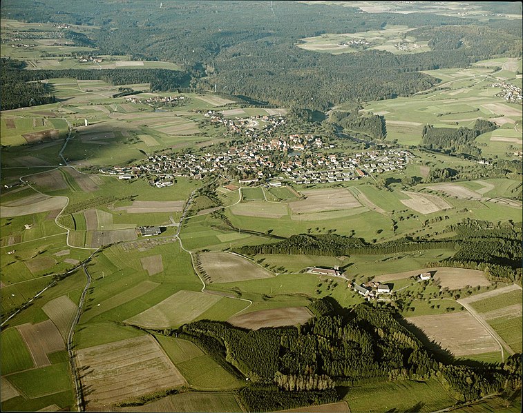
Ostalb (Ostalbkreis)

- district of Baden-Württemberg, Germany
 Hiking in Ostalb
Ostalbkreis, located in the state of Baden-Württemberg in Germany, is a fantastic destination for hiking enthusiasts. The region is characterized by its diverse landscapes, which include rolling hills, dense forests, and picturesque valleys, providing a variety of trails suitable for all levels of hikers.
Popular Hiking Areas and Trails:
-
Swabian Jura (Schwäbische Alb):
- The Swabian Jura is a prominent mountain range in the area, offering stunning views and a rich variety of flora and fauna. Trails like the Albsteig (Alb Trail) offer both challenging hikes and easier sections with breathtaking views over the surrounding countryside.
-
Hiking Trails around Aalen:
- Aalen, a major town in Ostalbkreis, is surrounded by beautiful trails. The Aalen Panorama Trail (Panoramaweg) is particularly noteworthy, providing beautiful vistas and a chance to explore the historical sites around the town.
-
Schwäbischer Wald:
- This nearby natural park is filled with dense forests and offers a multitude of well-marked trails, ideal for those who enjoy nature and serenity. The trails vary from short walks to longer hiking routes.
-
Limes Trail (Limes-Wanderweg):
- This historic trail follows parts of the Roman border from the 1st century AD, showcasing not only natural beauty but also fascinating historical landmarks. It’s great for those interested in both hiking and history.
Trail Features:
- Marking: Most trails in Ostalbkreis are well-marked with signposts and maps available at trailheads.
- Difficulty Levels: There are trails that cater to beginners as well as more challenging routes for experienced hikers.
- Amenities: Many trails have rest areas and can be found near local eateries or picnic spots, allowing for a pleasant day out.
Best Seasons to Hike:
- Spring (March - May): The weather is mild, and the flowers begin to bloom, making it a picturesque time to hike.
- Fall (September - November): The crisp air and stunning autumn colors create a beautiful backdrop for hiking.
Tips for Hikers:
- Preparation: Always check the weather forecast and trail conditions before heading out. Bring appropriate gear, such as sturdy shoes, water, and snacks.
- Leave No Trace: Follow the principles of Leave No Trace to keep the natural surroundings pristine.
- Local Guidance: Consider joining local hiking groups or guided tours for a more enriching experience.
Hiking in Ostalbkreis offers a great way to explore the natural beauty of the region while enjoying the outdoors. Whether you are looking for a leisurely stroll or a challenging hike, there are plenty of options to choose from!
- Country:

- Capital: Aalen
- Licence Plate Code: AA
- Coordinates: 48° 52' 0" N, 10° 6' 0" E


- GPS tracks (wikiloc): [Link]
- AboveSeaLevel: 436 м m
- Area: 1511.57 sq km
- Population: 311587
- Web site: http://www.ostalbkreis.de/
- Wikipedia en: wiki(en)
- Wikipedia: wiki(de)
- Wikidata storage: Wikidata: Q8522
- Wikipedia Commons Category: [Link]
- Freebase ID: [/m/01kj3n]
- GeoNames ID: Alt: [2856827]
- BnF ID: [12134525x]
- VIAF ID: Alt: [139260996]
- OSM relation ID: [62708]
- GND ID: Alt: [4043998-7]
- archINFORM location ID: [2551]
- Library of Congress authority ID: Alt: [n85201331]
- TGN ID: [7116181]
- ISNI: Alt: [0000 0004 0565 5225]
- NUTS code: [DE11D]
- Ringgold ID: [40191]
- German district key: 08136
Includes regions:


Ellwangen (Jagst)
- municipality in Germany
Hiking in Ellwangen (Jagst)
Ellwangen, located in the eastern part of the Baden-Württemberg region in Germany, is surrounded by beautiful natural landscapes that are perfect for hiking enthusiasts. The area offers a variety of trails suitable for different skill levels, ranging from easy walks through scenic countryside to more challenging hikes that take you through forests and hills....
- Country:
- Postal Code: 73479
- Local Dialing Code: 07965; 07961
- Licence Plate Code: AA
- Coordinates: 48° 57' 40" N, 10° 7' 50" E
- GPS tracks (wikiloc): [Link]
- AboveSeaLevel: 490 м m
- Area: 127.45 sq km
- Population: 24339
- Web site: [Link]


Essingen
- municipality in Germany
Hiking in Essingen
Essingen, located in the Swabian region of Württemberg, Germany, is a charming village that offers a variety of hiking opportunities in a picturesque setting. The surrounding landscape is characterized by rolling hills, forests, and meadows, making it ideal for both casual walks and more challenging hikes....
- Country:
- Postal Code: 73457
- Local Dialing Code: 07365
- Licence Plate Code: UL
- Coordinates: 48° 48' 30" N, 10° 1' 40" E
- GPS tracks (wikiloc): [Link]
- AboveSeaLevel: 508 м m
- Area: 58.50 sq km
- Population: 6372
- Web site: [Link]


Kirchheim am Ries
- municipality in Germany
Hiking in Kirchheim am Ries
Kirchheim am Ries is a charming village located in the Bavarian region of Germany, renowned for its picturesque landscapes and tranquil atmosphere, making it a great destination for hiking enthusiasts. Here are some highlights and tips for hiking in this area:...
- Country:
- Postal Code: 73467
- Local Dialing Code: 07362
- Licence Plate Code: AA
- Coordinates: 48° 53' 0" N, 10° 24' 0" E
- GPS tracks (wikiloc): [Link]
- AboveSeaLevel: 485 м m
- Area: 21.05 sq km
- Population: 1867
- Web site: [Link]


Riesbürg
- municipality in Germany
Hiking in Riesbürg
Riesbürg is a charming area in Bavaria, Germany, known for its picturesque landscapes and hiking opportunities. Nestled in the beautiful Franconian region, it offers a variety of hiking trails suitable for different skill levels. Here are some points to consider when hiking in Riesbürg:...
- Country:
- Postal Code: 73469
- Local Dialing Code: 09081
- Licence Plate Code: AA
- Coordinates: 48° 51' 2" N, 10° 26' 2" E
- GPS tracks (wikiloc): [Link]
- AboveSeaLevel: 445 м m
- Area: 17.96 sq km
- Population: 2285
- Web site: [Link]


Heubach
- municipality in Germany
Hiking in Heubach
Heubach is a picturesque town located in Baden-Württemberg, Germany, surrounded by the beautiful landscape of the Swabian Alps. It offers several opportunities for hiking enthusiasts, with trails that cater to various skill levels and interests....
- Country:
- Postal Code: 73540
- Local Dialing Code: 07173
- Licence Plate Code: AA
- Coordinates: 48° 47' 0" N, 9° 56' 0" E
- GPS tracks (wikiloc): [Link]
- AboveSeaLevel: 466 м m
- Area: 25.81 sq km
- Population: 9772
- Web site: [Link]


Tannhausen
- municipality in Germany
Hiking in Tannhausen
Tannhausen is a small town located in the state of Baden-Württemberg, Germany. While it may not be as well-known as some larger hiking destinations, it offers beautiful landscapes and a glimpse into the region's natural beauty. Here are some things to consider when hiking in the Tannhausen area:...
- Country:
- Postal Code: 73497
- Local Dialing Code: 07964
- Licence Plate Code: AA
- Coordinates: 48° 58' 45" N, 10° 21' 41" E
- GPS tracks (wikiloc): [Link]
- AboveSeaLevel: 504 м m
- Area: 17.74 sq km
- Population: 1808
- Web site: [Link]

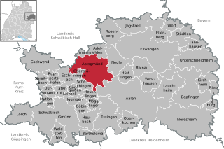
Abtsgmünd
- municipality in Germany
Hiking in Abtsgmünd
Abtsgmünd is a picturesque town located in the Ostalbkreis district of Baden-Württemberg, Germany. Surrounded by beautiful landscapes, it offers a range of hiking opportunities for outdoor enthusiasts. Here’s what you need to know about hiking in and around Abtsgmünd:...
- Country:
- Postal Code: 73453
- Local Dialing Code: 07366
- Licence Plate Code: AA
- Coordinates: 48° 53' 42" N, 10° 0' 6" E
- GPS tracks (wikiloc): [Link]
- AboveSeaLevel: 375 м m
- Area: 71.6 sq km
- Population: 7341
- Web site: [Link]

Adelmannsfelden
- municipality in Germany
Hiking in Adelmannsfelden
Adelmannsfelden is a picturesque area located in Baden-Württemberg, Germany, known for its lush landscapes and scenic hiking trails. The region offers a variety of hiking opportunities suitable for different skill levels, from leisurely walks to more challenging treks. Here are a few highlights about hiking in Adelmannsfelden:...
- Country:
- Postal Code: 73486
- Local Dialing Code: 07963
- Licence Plate Code: AA
- Coordinates: 48° 57' 17" N, 10° 0' 17" E
- GPS tracks (wikiloc): [Link]
- AboveSeaLevel: 476 м m
- Area: 22.9 sq km
- Population: 1749
- Web site: [Link]


Aalen
- city in Baden-Württemberg, Germany
Hiking in Aalen
Aalen, located in the Baden-Württemberg region of Germany, is known for its beautiful landscapes and rich history, making it a great location for hiking enthusiasts. Here are some highlights and tips for hiking in Aalen:...
- Country:
- Postal Code: 73430–73434
- Local Dialing Code: 07367; 07366; 07361
- Licence Plate Code: AA
- Coordinates: 48° 50' 14" N, 10° 5' 37" E
- GPS tracks (wikiloc): [Link]
- AboveSeaLevel: 430 м m
- Area: 146.63 sq km
- Population: 67344
- Web site: [Link]

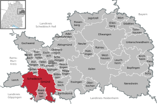
Schwäbisch Gmünd
- town in Baden-Württemberg, Germany
Hiking in Schwäbisch Gmünd
Schwäbisch Gmünd is a charming town located in the Swabian region of Germany, surrounded by picturesque landscapes, making it a great destination for hiking enthusiasts. The area offers a variety of trails that cater to different fitness levels and interests. Here are some highlights and tips for hiking in Schwäbisch Gmünd:...
- Country:
- Postal Code: 73525–73529
- Local Dialing Code: 07332; 07165; 07173; 07171
- Licence Plate Code: AA, GD
- Coordinates: 48° 48' 0" N, 9° 48' 0" E
- GPS tracks (wikiloc): [Link]
- AboveSeaLevel: 321 м m
- Area: 113.78 sq km
- Population: 59166
- Web site: [Link]
Neuler
- town in Baden-Württemberg, Germany
Hiking in Neuler
Neuler, located in Germany, is a small municipality situated in the state of Baden-Württemberg. While it may not be as well-known as some larger hiking destinations, Neuler and its surrounding areas do offer some beautiful landscapes for hiking enthusiasts....
- Country:
- Postal Code: 73491
- Local Dialing Code: 07961
- Licence Plate Code: AA
- Coordinates: 48° 55' 43" N, 10° 4' 10" E
- GPS tracks (wikiloc): [Link]
- AboveSeaLevel: 518 м m
- Area: 36.27 sq km
- Population: 3125
- Web site: [Link]


Bartholomä
- municipality in Germany
Hiking in Bartholomä
Bartholomä is a picturesque village located in the Swabian region of Germany, surrounded by beautiful landscapes ideal for hiking enthusiasts. The area offers a variety of trails that cater to different skill levels, allowing hikers to experience the charming nature, historical sites, and local culture....
- Country:
- Postal Code: 73566
- Local Dialing Code: 07173
- Licence Plate Code: AA
- Coordinates: 48° 45' 13" N, 9° 59' 15" E
- GPS tracks (wikiloc): [Link]
- AboveSeaLevel: 646 м m
- Area: 20.75 sq km
- Population: 2026
- Web site: [Link]


Gschwend
- municipality in Germany
Hiking in Gschwend
Gschwend, located in Baden-Württemberg, is a picturesque village that offers a variety of hiking opportunities set against a backdrop of beautiful landscapes and wooded areas. The region is known for its serene environment, making it ideal for nature lovers and outdoor enthusiasts....
- Country:
- Postal Code: 74417
- Local Dialing Code: 07972
- Licence Plate Code: AA
- Coordinates: 48° 56' 0" N, 9° 44' 40" E
- GPS tracks (wikiloc): [Link]
- AboveSeaLevel: 473 м m
- Area: 54.5 sq km
- Population: 4893
- Web site: [Link]


Jagstzell
- municipality in Germany
Hiking in Jagstzell
Jagstzell is a charming municipality located in the state of Baden-Württemberg, Germany, known for its picturesque landscapes and scenic hiking opportunities. The region is characterized by rolling hills, wooded areas, and meandering streams, making it an ideal spot for outdoor enthusiasts....
- Country:
- Postal Code: 73489
- Local Dialing Code: 07967
- Licence Plate Code: AA
- Coordinates: 49° 1' 50" N, 10° 5' 51" E
- GPS tracks (wikiloc): [Link]
- AboveSeaLevel: 427 м m
- Area: 37.97 sq km
- Population: 2304
- Web site: [Link]

Iggingen
- municipality in Germany
Hiking in Iggingen
Iggingen, located in the Baden-Württemberg region of Germany, offers a serene environment for hiking enthusiasts. Nestled in the picturesque landscape of rolling hills and forests, it provides a range of trails suitable for various skill levels, from leisurely walks to more challenging hikes....
- Country:
- Postal Code: 73574
- Local Dialing Code: 07175
- Licence Plate Code: AA
- Coordinates: 48° 49' 54" N, 9° 52' 44" E
- GPS tracks (wikiloc): [Link]
- AboveSeaLevel: 465 м m
- Area: 11.44 sq km
- Population: 2580
- Web site: [Link]


Unterschneidheim
- municipality in Germany
Hiking in Unterschneidheim
Unterschneidheim is a charming area located in Bavaria, Germany, known for its picturesque landscapes and outdoor activities including hiking. The region offers a variety of trails that cater to different skill levels, from easy walks suitable for families to more challenging hikes for experienced trekkers....
- Country:
- Postal Code: 73485
- Local Dialing Code: 07966
- Licence Plate Code: AA
- Coordinates: 48° 56' 0" N, 10° 22' 0" E
- GPS tracks (wikiloc): [Link]
- AboveSeaLevel: 487 м m
- Area: 68.06 sq km
- Population: 4697
- Web site: [Link]


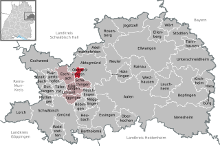
Eschach
- municipality in Germany
Hiking in Eschach
Eschach, located in the Baden-Württemberg region of Germany, is a small town surrounded by beautiful landscapes, making it a great spot for hiking enthusiasts. The area offers various trails that cater to different skill levels, providing opportunities to explore the natural beauty of the region....
- Country:
- Postal Code: 73569
- Local Dialing Code: 07175
- Licence Plate Code: AA
- Coordinates: 48° 53' 18" N, 9° 52' 11" E
- GPS tracks (wikiloc): [Link]
- AboveSeaLevel: 498 м m
- Area: 20.27 sq km
- Population: 1759
- Web site: [Link]


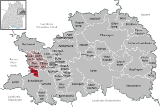
Göggingen
- municipality in Germany
Hiking in Göggingen
Göggingen is a district in the city of Augsburg, located in Bavaria, Germany. While it may not be as famous for hiking as some mountainous regions, it offers some pleasant walking paths and trails that can be enjoyed by hikers of various levels....
- Country:
- Postal Code: 73575; 73571
- Local Dialing Code: 07175
- Licence Plate Code: AA
- Coordinates: 48° 51' 38" N, 9° 53' 0" E
- GPS tracks (wikiloc): [Link]
- AboveSeaLevel: 488 м m
- Area: 11.38 sq km
- Population: 2430
- Web site: [Link]


Oberkochen
- municipality in Germany
Hiking in Oberkochen
Oberkochen, located in the state of Baden-Württemberg in Germany, is surrounded by beautiful landscapes and offers various hiking opportunities. Here are some highlights and tips for hiking in and around Oberkochen:...
- Country:
- Postal Code: 73447
- Local Dialing Code: 07364
- Licence Plate Code: AA
- Coordinates: 48° 47' 2" N, 10° 6' 19" E
- GPS tracks (wikiloc): [Link]
- AboveSeaLevel: 496 м m
- Area: 23.57 sq km
- Population: 7761
- Web site: [Link]


Täferrot
- municipality in Germany
Hiking in Täferrot
Täferrot is a beautiful area in the Swabian Jura, located in Germany, known for its stunning landscapes, diverse flora and fauna, and well-maintained hiking trails. Here are some key points about hiking in Täferrot:...
- Country:
- Postal Code: 73527
- Local Dialing Code: 07175
- Licence Plate Code: AA
- Coordinates: 48° 50' 59" N, 9° 50' 18" E
- GPS tracks (wikiloc): [Link]
- AboveSeaLevel: 425 м m
- Area: 12 sq km
- Population: 1001
- Web site: [Link]

Waldstetten
- municipality in Germany, Baden-Württemberg
Hiking in Waldstetten
Waldstetten, located in the state of Baden-Württemberg, Germany, offers a variety of hiking opportunities amidst scenic landscapes, including rolling hills, forests, and beautiful countryside. The region is known for its well-maintained trails and picturesque views, making it a great destination for both novice and experienced hikers....
- Country:
- Postal Code: 73550
- Local Dialing Code: 07171
- Licence Plate Code: AA
- Coordinates: 48° 46' 0" N, 9° 49' 13" E
- GPS tracks (wikiloc): [Link]
- AboveSeaLevel: 387 м m
- Area: 20.95 sq km
- Population: 7071
- Web site: [Link]


Rainau
- municipality in Germany
Hiking in Rainau
Rainau is a picturesque municipality located in Baden-Württemberg, Germany. Known for its beautiful landscapes and surrounding nature, it can be a great destination for hiking enthusiasts. Here are some key points to consider when planning a hiking trip in Rainau:...
- Country:
- Postal Code: 73492
- Local Dialing Code: 07961
- Licence Plate Code: AA
- Coordinates: 48° 55' 39" N, 10° 8' 19" E
- GPS tracks (wikiloc): [Link]
- AboveSeaLevel: 462 м m
- Area: 25.45 sq km
- Population: 3295
- Web site: [Link]


Ruppertshofen
- municipality in Baden-Württemberg, Germany
Hiking in Ruppertshofen
Ruppertshofen is a charming village located in Baden-Württemberg, Germany. The area around Ruppertshofen offers a variety of scenic hiking opportunities that showcase the beautiful landscapes of the Swabian region. Here are some highlights and tips for hiking in and around Ruppertshofen:...
- Country:
- Postal Code: 73577
- Local Dialing Code: 07176
- Licence Plate Code: AA
- Coordinates: 48° 52' 57" N, 9° 48' 55" E
- GPS tracks (wikiloc): [Link]
- AboveSeaLevel: 510 м m
- Area: 14.22 sq km
- Population: 1814
- Web site: [Link]


Stödtlen
- municipality in Germany
Hiking in Stödtlen
Stödtlen is a small municipality located in Baden-Württemberg, Germany, near the scenic landscapes of the Swabian Jura and the beautifully diverse natural areas of the region. While it may not be as widely known as some larger hiking destinations, it offers opportunities for outdoor enthusiasts to explore its charming surroundings....
- Country:
- Postal Code: 73495
- Local Dialing Code: 07964
- Licence Plate Code: AA
- Coordinates: 49° 0' 0" N, 10° 18' 0" E
- GPS tracks (wikiloc): [Link]
- AboveSeaLevel: 489 м m
- Area: 31.19 sq km
- Population: 1883
- Web site: [Link]


Spraitbach
- municipality in Germany
Hiking in Spraitbach
Spraitbach is a small town located in Baden-Württemberg, Germany, which offers a charming and picturesque environment for hiking enthusiasts. The surrounding area is characterized by rolling hills, lush forests, and beautiful meadows, making it an ideal spot for both casual and more experienced hikers....
- Country:
- Postal Code: 73565
- Local Dialing Code: 07176
- Licence Plate Code: AA
- Coordinates: 48° 52' 50" N, 9° 45' 44" E
- GPS tracks (wikiloc): [Link]
- AboveSeaLevel: 539 м m
- Area: 12.39 sq km
- Population: 3270
- Web site: [Link]


Schechingen
- municipality in Germany
Hiking in Schechingen
Schechingen is a small municipality located in the state of Baden-Württemberg, Germany. Although it may not be as well-known as some larger hiking destinations, the surrounding area offers some beautiful landscapes and opportunities for outdoor activities, including hiking....
- Country:
- Postal Code: 73579
- Local Dialing Code: 07175
- Licence Plate Code: AA
- Coordinates: 48° 52' 24" N, 9° 55' 3" E
- GPS tracks (wikiloc): [Link]
- AboveSeaLevel: 484 м m
- Area: 11.87 sq km
- Population: 2279
- Web site: [Link]


Wört
- municipality in Germany
Hiking in Wört
Wört is a beautiful area in Germany that fosters a great hiking environment. While it may not be as widely known as some of the larger hiking destinations in the country, it offers scenic views and various trails suitable for different skill levels....
- Country:
- Postal Code: 73499
- Local Dialing Code: 07964
- Licence Plate Code: AA
- Coordinates: 49° 1' 50" N, 10° 16' 21" E
- GPS tracks (wikiloc): [Link]
- AboveSeaLevel: 455 м m
- Area: 18.17 sq km
- Population: 1367
- Web site: [Link]


Rosenberg
- municipality in the district of Ostalbkreis, Germany
Hiking in Rosenberg
Rosenberg, located in the Ostalbkreis district of Baden-Württemberg, Germany, is a great area for hiking, featuring picturesque landscapes, beautiful trails, and a rich natural environment. Here are some details to help you plan your hiking adventure in this region:...
- Country:
- Postal Code: 73494
- Local Dialing Code: 07967
- Licence Plate Code: AA
- Coordinates: 49° 1' 8" N, 10° 1' 53" E
- GPS tracks (wikiloc): [Link]
- AboveSeaLevel: 492 м m
- Area: 41.02 sq km
- Population: 2652
- Web site: [Link]

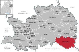
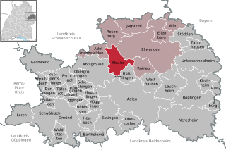
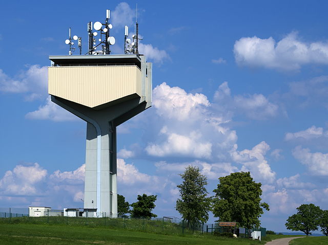
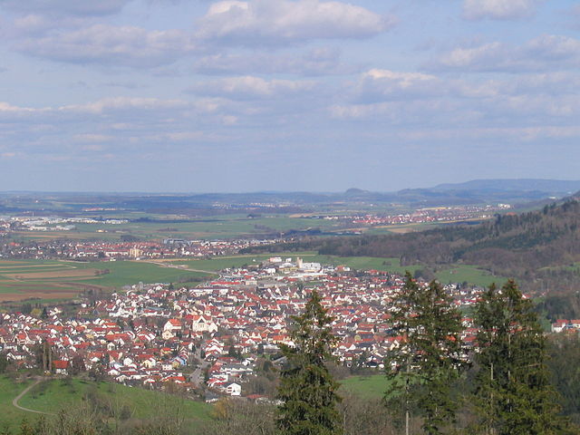
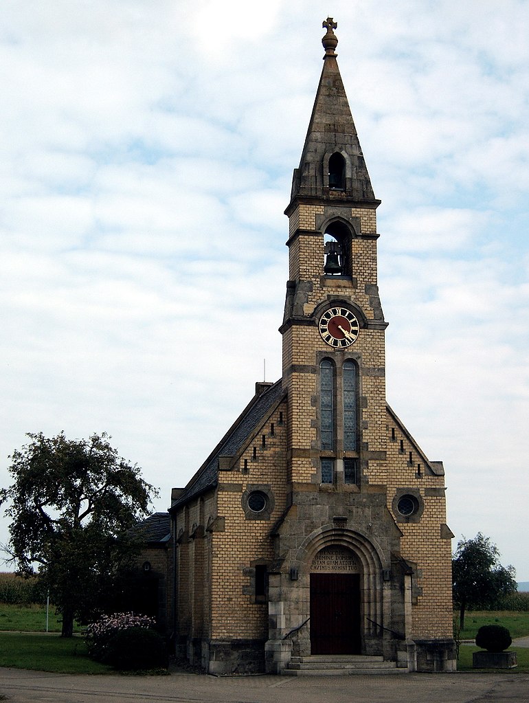
Neresheim
- municipality in Germany
Hiking in Neresheim
Neresheim, a small town located in the Swabian region of Germany, offers some lovely hiking opportunities, especially for those who appreciate scenic rural landscapes and historical sites. Here are some details to consider if you’re looking to hike in and around Neresheim:...
- Country:
- Postal Code: 73450
- Local Dialing Code: 07326
- Licence Plate Code: AA
- Coordinates: 48° 45' 15" N, 10° 20' 4" E
- GPS tracks (wikiloc): [Link]
- AboveSeaLevel: 503 м m
- Area: 118.52 sq km
- Population: 7912
- Web site: [Link]


Durlangen
- municipality in Germany
Hiking in Durlangen
Durlangen, located in the Swabian region of Germany, offers a variety of hiking opportunities that showcase the beauty of the area, including scenic landscapes, forests, and rolling hills. Here are some key aspects to consider when hiking in Durlangen:...
- Country:
- Postal Code: 73568
- Local Dialing Code: 07176
- Licence Plate Code: AA
- Coordinates: 48° 51' 23" N, 9° 47' 48" E
- GPS tracks (wikiloc): [Link]
- AboveSeaLevel: 489 м m
- Area: 10.43 sq km
- Population: 2917
- Web site: [Link]
Mutlangen
- municipality in Germany
Hiking in Mutlangen
Mutlangen, a small municipality in the Swabian Jura region of Germany, offers scenic hiking opportunities for enthusiasts of all levels. Nestled in a picturesque landscape, it features beautiful trails that allow hikers to explore the surrounding nature....
- Country:
- Postal Code: 73557
- Local Dialing Code: 07171
- Licence Plate Code: AA
- Coordinates: 48° 49' 33" N, 9° 47' 50" E
- GPS tracks (wikiloc): [Link]
- AboveSeaLevel: 452 м m
- Area: 8.78 sq km
- Population: 6580
- Web site: [Link]

Leinzell
- municipality in Germany
Hiking in Leinzell
Leinzell, located in the eastern part of the state of Baden-Württemberg, Germany, is a lovely area for hiking enthusiasts. The region provides a mix of picturesque landscapes, forests, and hills, making it suitable for various hiking experiences. Here are some highlights of hiking in Leinzell:...
- Country:
- Postal Code: 73575
- Local Dialing Code: 07175
- Licence Plate Code: AA
- Coordinates: 48° 50' 58" N, 9° 52' 39" E
- GPS tracks (wikiloc): [Link]
- AboveSeaLevel: 404 м m
- Area: 2.11 sq km
- Population: 2010
- Web site: [Link]


Lauchheim
- municipality in Germany
Hiking in Lauchheim
Lauchheim, located in the state of Baden-Württemberg, Germany, is a charming town that offers various hiking opportunities, particularly in the surrounding regions of the Swabian Jura and the picturesque countryside....
- Country:
- Postal Code: 73466
- Local Dialing Code: 07363
- Licence Plate Code: AA
- Coordinates: 48° 52' 18" N, 10° 14' 40" E
- GPS tracks (wikiloc): [Link]
- AboveSeaLevel: 492 м m
- Area: 40.86 sq km
- Population: 4714
- Web site: [Link]


Hüttlingen
- municipality in Germany
Hiking in Hüttlingen
Hüttlingen is a charming village located in the Baden-Württemberg region of Germany. Although it's a small area, there are several attractive hiking opportunities in and around Hüttlingen, thanks to its picturesque landscapes, forests, and historical sites....
- Country:
- Postal Code: 73460
- Local Dialing Code: 07361
- Licence Plate Code: AA
- Coordinates: 48° 53' 34" N, 10° 6' 2" E
- GPS tracks (wikiloc): [Link]
- AboveSeaLevel: 408 м m
- Area: 18.71 sq km
- Population: 6095
- Web site: [Link]

Obergröningen
- municipality in Germany
Hiking in Obergröningen
Obergröningen is a charming village located in Germany, specifically in the state of Baden-Württemberg. The area is known for its beautiful landscapes and outdoor recreational opportunities, making it a great destination for hiking enthusiasts....
- Country:
- Postal Code: 73569
- Local Dialing Code: 07975
- Licence Plate Code: AA
- Coordinates: 48° 53' 40" N, 9° 54' 34" E
- GPS tracks (wikiloc): [Link]
- AboveSeaLevel: 500 м m
- Area: 5.86 sq km
- Population: 456


Ellenberg
- municipality in Baden-Württemberg, Germany
Hiking in Ellenberg
Ellenberg is a charming village located in the Baden-Württemberg region of Germany, surrounded by beautiful natural landscapes that offer excellent hiking opportunities. The area is characterized by rolling hills, lush forests, and scenic viewpoints, making it a wonderful destination for outdoor enthusiasts....
- Country:
- Postal Code: 73488
- Local Dialing Code: 07966; 07965; 07961; 07962
- Licence Plate Code: AA
- Coordinates: 49° 0' 55" N, 10° 13' 1" E
- GPS tracks (wikiloc): [Link]
- AboveSeaLevel: 576 м m
- Area: 30.2 sq km
- Population: 1673
- Web site: [Link]

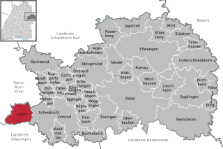
Lorch
- municipality in Germany
Hiking in Lorch
Lorch (Württemberg), located in the state of Baden-Württemberg, Germany, is surrounded by beautiful landscapes that make it an excellent destination for hiking enthusiasts. The region is characterized by its rolling hills, vineyards, and scenic views along the Rems River. Here are some highlights of hiking in this area:...
- Country:
- Postal Code: 73547
- Local Dialing Code: 07172
- Licence Plate Code: AA
- Coordinates: 48° 47' 54" N, 9° 41' 18" E
- GPS tracks (wikiloc): [Link]
- AboveSeaLevel: 288 м m
- Area: 34.28 sq km
- Population: 10607
- Web site: [Link]


Mögglingen
- municipality in Germany
Hiking in Mögglingen
Mögglingen is a charming village located in the Baden-Württemberg region of Germany. It's surrounded by picturesque landscapes that make it an excellent destination for hiking enthusiasts. Here are some highlights and tips for hiking in and around Mögglingen:...
- Country:
- Postal Code: 73563
- Local Dialing Code: 07174
- Licence Plate Code: AA
- Coordinates: 48° 49' 24" N, 9° 57' 45" E
- GPS tracks (wikiloc): [Link]
- AboveSeaLevel: 413 м m
- Area: 10.27 sq km
- Population: 4212
- Web site: [Link]


Böbingen an der Rems
- municipality in Germany
Hiking in Böbingen an der Rems
Böbingen an der Rems is a quaint town in the state of Baden-Württemberg, Germany, situated near the Rems River. The picturesque landscapes surrounding the area make it an excellent destination for hiking enthusiasts. Here’s what you should know about hiking in and around Böbingen:...
- Country:
- Postal Code: 73560
- Local Dialing Code: 07173
- Licence Plate Code: AA
- Coordinates: 48° 49' 10" N, 9° 55' 17" E
- GPS tracks (wikiloc): [Link]
- AboveSeaLevel: 385 м m
- Area: 12.22 sq km
- Population: 4529
- Web site: [Link]


Bopfingen
- town in Germany
Hiking in Bopfingen
Bopfingen, located in the state of Baden-Württemberg, Germany, is situated in the picturesque area of the Swabian Jura, making it a fantastic destination for hiking enthusiasts. The region boasts a variety of trails that cater to various skill levels and offer diverse landscapes, including forests, hills, and stunning vistas....
- Country:
- Postal Code: 73441
- Local Dialing Code: 07362
- Licence Plate Code: AA
- Coordinates: 48° 51' 25" N, 10° 21' 8" E
- GPS tracks (wikiloc): [Link]
- AboveSeaLevel: 468 м m
- Area: 76.98 sq km
- Population: 11787
- Web site: [Link]


Westhausen
- municipality in Germany
Hiking in Westhausen
Westhausen, located in the Ostalbkreis region of Baden-Württemberg, Germany, offers a variety of hiking opportunities for outdoor enthusiasts. The area is characterized by its picturesque landscapes, including rolling hills, forests, and agricultural lands, making it an ideal location for nature walks and hiking....
- Country:
- Postal Code: 73463
- Local Dialing Code: 07363
- Licence Plate Code: AA
- Coordinates: 48° 53' 2" N, 10° 11' 11" E
- GPS tracks (wikiloc): [Link]
- AboveSeaLevel: 474 м m
- Area: 38.46 sq km
- Population: 5914
- Web site: [Link]


Heuchlingen
- municipality in Germany
Hiking in Heuchlingen
Heuchlingen is a small village located in the Swabian region of Germany, specifically in the state of Baden-Württemberg. While it may not be as widely known for hiking as some other regions, it is surrounded by beautiful nature, making it a potential spot for outdoor activities....
- Country:
- Postal Code: 73572
- Local Dialing Code: 07174
- Licence Plate Code: AA
- Coordinates: 48° 51' 8" N, 9° 56' 38" E
- GPS tracks (wikiloc): [Link]
- AboveSeaLevel: 388 м m
- Area: 9.03 sq km
- Population: 1785
- Web site: [Link]
Shares border with regions:
Donau-Ries
- district in Bavaria, Germany
Hiking in Donau-Ries
Donau-Ries is a beautiful region in Bavaria, Germany, known for its stunning landscapes, rich history, and cultural significance. Spanning both the Danube River and the Ries crater, this area offers diverse hiking opportunities for both beginners and more experienced trekkers....
- Country:
- Capital: Donauwörth
- Licence Plate Code: NÖ; DON
- Coordinates: 48° 49' 48" N, 10° 40' 12" E
- GPS tracks (wikiloc): [Link]
- AboveSeaLevel: 508 м m
- Area: 1275.00 sq km
- Population: 117483
- Web site: [Link]

Ansbach
- district in Bavaria, Germany
Hiking in Ansbach
Ansbach district, located in the region of Bavaria, Germany, offers a variety of hiking opportunities suitable for different skill levels. The region is characterized by its picturesque landscapes, including rolling hills, forests, and historical sites, making it a great destination for outdoor enthusiasts....
- Country:
- Capital: Ansbach
- Licence Plate Code: ROT; FEU; DKB; AN
- Coordinates: 49° 19' 48" N, 10° 30' 0" E
- GPS tracks (wikiloc): [Link]
- AboveSeaLevel: 426 м m
- Area: 1972.00 sq km
- Population: 157632
- Web site: [Link]