
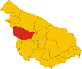
Ostuni (Ostuni)
.svg)
- Italian comune
 Hiking in Ostuni
Hiking in Ostuni, a picturesque town in the Apulia region of Italy, offers a unique blend of stunning landscapes, rich history, and beautiful Mediterranean climate. Here's what you can expect when hiking in this area:
Scenic Trails
- Cyclic Paths: Several marked trails in and around Ostuni allow for various hiking experiences. These paths often pass through olive groves, vineyards, and the iconic white-washed buildings of the town.
- Acqua Blanca Trail: A popular hiking route that offers panoramic views of the surrounding countryside, including the Adriatic Sea on clear days.
- Parco Regionale Dune Costiere: Just a short distance from Ostuni, this coastal park features trails that meander through sand dunes, coastal forests, and beaches.
Terrain and Difficulty
- The terrain varies from flat, easy paths to more challenging hilly routes. Most trails are suitable for beginners, but some may require a moderate level of fitness.
- Remember to check trail markings and maps, as some paths may not be as well-maintained.
Flora and Fauna
- The region is home to a diverse ecosystem, including typical Mediterranean flora like olive trees, cacti, and various wildflowers, especially in spring.
- Bird-watchers may enjoy spotting local bird species, particularly in the coastal area.
Historical Sites
- As you hike, you’ll encounter historical landmarks, including ancient trulli (traditional stone huts), churches, and ruins that reflect the rich heritage of the area.
- Explore the Old Town of Ostuni with its interesting architecture and winding streets at the beginning or end of your hike.
Seasonal Considerations
- The best seasons for hiking in Ostuni are spring (March to May) and autumn (September to November) when temperatures are mild and the landscape is at its colorful best.
- Summer can be hot, so it's advisable to hike early in the morning or later in the evening and always carry plenty of water.
Tips for Hikers
- Wear comfortable hiking shoes and dress in layers to accommodate temperature changes throughout the day.
- Bring plenty of water, snacks, and a map or GPS device for navigation.
- Respect local wildlife and nature, and follow Leave No Trace principles.
Overall, hiking in Ostuni provides not only a chance to appreciate the natural beauty of the region but also an opportunity to immerse yourself in the cultural heritage of this charming Italian town. Happy hiking!
- Country:

- Postal Code: 72017
- Local Dialing Code: 0831
- Licence Plate Code: BR
- Coordinates: 40° 43' 56" N, 17° 34' 40" E


- GPS tracks (wikiloc): [Link]
- AboveSeaLevel: 207 м m
- Area: 225.56 sq km
- Population: 31197
- Web site: http://www.comune.ostuni.br.it
- Wikipedia en: wiki(en)
- Wikipedia: wiki(it)
- Wikidata storage: Wikidata: Q51872
- Wikipedia Commons Category: [Link]
- Freebase ID: [/m/02tsv_]
- GeoNames ID: Alt: [6538961]
- VIAF ID: Alt: [133689810]
- OSM relation ID: [40666]
- MusicBrainz area ID: [4cf0fc0e-360b-499e-96bb-50df939d6ca7]
- TGN ID: [1045803]
- UN/LOCODE: [ITOSU]
- Gran Enciclopèdia Catalana ID: [0047934]
- Digital Atlas of the Roman Empire ID: [30410]
- DMOZ ID: Alt: [Regional/Europe/Italy/Puglia/Localities/Ostuni/]
- ISTAT ID: 074012
- Italian cadastre code: G187
Shares border with regions:


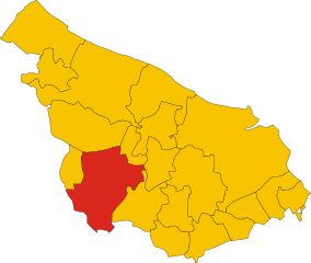
Brindisi
- Italian comune
Hiking in Brindisi
Brindisi, located in the Apulia region of southern Italy, offers a variety of hiking opportunities that showcase its beautiful landscapes, coastal scenery, and historical sites. Here are some key hiking spots and experiences in and around Brindisi:...
- Country:
- Postal Code: 72100
- Local Dialing Code: 0831
- Licence Plate Code: BR
- Coordinates: 40° 38' 18" N, 17° 56' 45" E
- GPS tracks (wikiloc): [Link]
- AboveSeaLevel: 15 м m
- Area: 332.98 sq km
- Population: 88126
- Web site: [Link]


Carovigno
- Italian comune
Hiking in Carovigno
Carovigno, a charming town in the Apulia region of southern Italy, offers a wonderful backdrop for hiking enthusiasts. Nestled along the Adriatic coast, it sits about 20 kilometers north of Brindisi and is surrounded by a mix of rugged coastline, olive groves, and picturesque countryside....
- Country:
- Postal Code: 72012
- Local Dialing Code: 0831
- Licence Plate Code: BR
- Coordinates: 40° 42' 26" N, 17° 39' 34" E
- GPS tracks (wikiloc): [Link]
- AboveSeaLevel: 172 м m
- Area: 106.62 sq km
- Population: 17120
- Web site: [Link]

Ceglie Messapica
- Italian comune
Hiking in Ceglie Messapica
Ceglie Messapica, located in the Apulia region of Italy, is a charming destination known for its rich history, stunning landscapes, and beautiful countryside, making it a great spot for hiking enthusiasts. Here are some highlights about hiking in the area:...
- Country:
- Postal Code: 72013
- Local Dialing Code: 0831
- Licence Plate Code: BR
- Coordinates: 40° 39' 0" N, 17° 31' 0" E
- GPS tracks (wikiloc): [Link]
- AboveSeaLevel: 298 м m
- Area: 132.02 sq km
- Population: 19833
- Web site: [Link]


Cisternino
- Italian comune
Hiking in Cisternino
Cisternino, located in the Puglia region of Italy, is a charming town known for its beautiful scenery, white-washed buildings, and rich agricultural landscapes. Here are some key points to consider when hiking in and around Cisternino:...
- Country:
- Postal Code: 72014
- Local Dialing Code: 080
- Licence Plate Code: BR
- Coordinates: 40° 45' 0" N, 17° 25' 0" E
- GPS tracks (wikiloc): [Link]
- AboveSeaLevel: 392 м m
- Area: 54.17 sq km
- Population: 11553
- Web site: [Link]


Fasano
- Italian comune
Hiking in Fasano
Fasano, located in the Puglia region of Italy, offers a unique and scenic experience for hikers. The area is characterized by rolling hills, olive groves, ancient masserie (farmhouses), and coastal views, making it a great destination for nature lovers and outdoor enthusiasts....
- Country:
- Postal Code: 72015
- Local Dialing Code: 080
- Licence Plate Code: BR
- Coordinates: 40° 50' 0" N, 17° 22' 0" E
- GPS tracks (wikiloc): [Link]
- AboveSeaLevel: 111 м m
- Area: 131.72 sq km
- Population: 39683
- Web site: [Link]

Francavilla Fontana
- Italian comune
Hiking in Francavilla Fontana
Francavilla Fontana is a town in the Apulia region of southern Italy, rich in history and culture, and surrounded by beautiful natural landscapes that can provide a great hiking experience. While Francavilla Fontana itself is more known for its architecture and historical sites, its surrounding areas offer opportunities for outdoor activities....
- Country:
- Postal Code: 72021
- Local Dialing Code: 0831
- Licence Plate Code: BR
- Coordinates: 40° 31' 53" N, 17° 35' 9" E
- GPS tracks (wikiloc): [Link]
- AboveSeaLevel: 142 м m
- Area: 177.94 sq km
- Population: 36358
- Web site: [Link]
San Michele Salentino
- Italian comune
Hiking in San Michele Salentino
San Michele Salentino is a charming town located in the Apulia (Puglia) region of Italy, known for its picturesque landscapes, historical sites, and traditional olive groves. While it may not be as famous for hiking as other regions in Italy, it offers some lovely opportunities for walking and exploring the countryside....
- Country:
- Postal Code: 72018
- Local Dialing Code: 0831
- Licence Plate Code: BR
- Coordinates: 40° 38' 0" N, 17° 38' 0" E
- GPS tracks (wikiloc): [Link]
- AboveSeaLevel: 153 м m
- Area: 26.53 sq km
- Population: 6258
- Web site: [Link]


San Vito dei Normanni
- Italian comune
Hiking in San Vito dei Normanni
San Vito dei Normanni, located in the Apulia region of southern Italy, is a charming town known for its beautiful landscapes, rich history, and traditional architecture. While it may not be as famous for hiking as some other regions in Italy, there are still opportunities for outdoor enthusiasts to explore the surrounding countryside and enjoy the natural beauty of the area....
- Country:
- Postal Code: 72019
- Local Dialing Code: 0831
- Licence Plate Code: BR
- Coordinates: 40° 39' 20" N, 17° 42' 13" E
- GPS tracks (wikiloc): [Link]
- AboveSeaLevel: 108 м m
- Area: 67.08 sq km
- Population: 19095
- Web site: [Link]


Martina Franca
- Italian city
Hiking in Martina Franca
Martina Franca, located in the Apulia region of Italy, is not only known for its Baroque architecture and beautiful historic center but also offers some scenic hiking opportunities in the surrounding countryside. Here are key points regarding hiking in and around Martina Franca:...
- Country:
- Postal Code: 74015
- Local Dialing Code: 080
- Licence Plate Code: TA
- Coordinates: 40° 42' 0" N, 17° 20' 0" E
- GPS tracks (wikiloc): [Link]
- AboveSeaLevel: 431 м m
- Area: 299.72 sq km
- Population: 48786
- Web site: [Link]