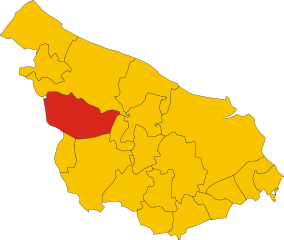
San Vito dei Normanni (San Vito dei Normanni)
.svg)
- Italian comune
 Hiking in San Vito dei Normanni
San Vito dei Normanni, located in the Apulia region of southern Italy, is a charming town known for its beautiful landscapes, rich history, and traditional architecture. While it may not be as famous for hiking as some other regions in Italy, there are still opportunities for outdoor enthusiasts to explore the surrounding countryside and enjoy the natural beauty of the area.
Hiking Opportunities Near San Vito dei Normanni
-
Natural Reserves and Parks:
- Riserva Naturale Orientata Torre Guaceto: This nearby nature reserve stretches along the coastline and offers a variety of trails through coastal habitats, including dunes, beaches, and wetlands. Exploring here can provide views of diverse wildlife, including migratory birds.
- Parco Naturale Regionale Dune Costiere: This park features natural coastal dunes and offers trails that showcase the local flora and fauna, alongside breathtaking sea views.
-
Countryside Trails:
- There are numerous dirt paths and tracks through the rural landscapes surrounding San Vito dei Normanni, where you can discover olive groves, vineyards, and charming Masserie (farmhouses). These trails can lead you through the traditional Mediterranean landscape, ideal for leisurely hikes.
-
Local Landmarks:
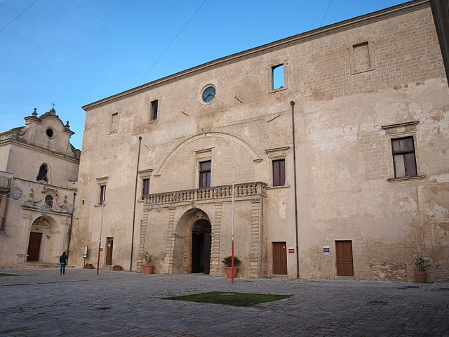
- Hiking is a great way to explore historic sites. You may want to hike to landmarks like the impressive Castello Normanno-Svevo or enjoy the stunning views from the surrounding hills.
Tips for Hiking in San Vito dei Normanni
-
Best Time to Hike: The ideal months for hiking are during the spring (April to June) and fall (September to October) when temperatures are milder, and the landscapes are vibrant.
-
Trail Maps: It’s a good idea to get local maps or information on hiking trails from tourist information centers or local guiding services, as they can give you insights into the best routes and hidden gems.
-
Safety: Always wear suitable footwear, carry plenty of water, and if hiking in secluded areas, let someone know your plans. Sun protection is also essential in the warmer months.
-
Respect Nature: As with any outdoor activity, practice Leave No Trace principles to preserve the natural beauty for future hikers.
Conclusion
While San Vito dei Normanni may not be the first destination that comes to mind for hiking in Italy, there are certainly opportunities to enjoy the outdoors, particularly for those who appreciate a more tranquil and authentic experience. Whether it’s a gentle stroll along the coast or a more challenging hike through the countryside, you can immerse yourself in the natural beauty and rich culture of the Apulia region.
- Country:

- Postal Code: 72019
- Local Dialing Code: 0831
- Licence Plate Code: BR
- Coordinates: 40° 39' 20" N, 17° 42' 13" E


- GPS tracks (wikiloc): [Link]
- AboveSeaLevel: 108 м m
- Area: 67.08 sq km
- Population: 19095
- Web site: http://www.sanvitobr.it/
- Wikipedia en: wiki(en)
- Wikipedia: wiki(it)
- Wikidata storage: Wikidata: Q51878
- Wikipedia Commons Gallery: [Link]
- Wikipedia Commons Category: [Link]
- Freebase ID: [/m/0bxr6s]
- GeoNames ID: Alt: [6540753]
- VIAF ID: Alt: [132604560]
- OSM relation ID: [40647]
- MusicBrainz area ID: [5eb9ec51-c1de-46e7-9885-fbc0e483ed47]
- WOEID: [723208]
- TGN ID: [7007532]
- Facebook Places ID: [113481055328872]
- ISTAT ID: 074017
- Italian cadastre code: I396
Shares border with regions:


Brindisi
- Italian comune
Hiking in Brindisi
Brindisi, located in the Apulia region of southern Italy, offers a variety of hiking opportunities that showcase its beautiful landscapes, coastal scenery, and historical sites. Here are some key hiking spots and experiences in and around Brindisi:...
- Country:
- Postal Code: 72100
- Local Dialing Code: 0831
- Licence Plate Code: BR
- Coordinates: 40° 38' 18" N, 17° 56' 45" E
- GPS tracks (wikiloc): [Link]
- AboveSeaLevel: 15 м m
- Area: 332.98 sq km
- Population: 88126
- Web site: [Link]


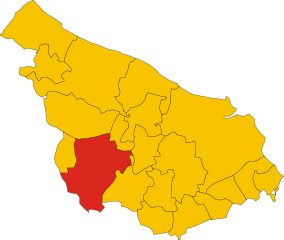
Carovigno
- Italian comune
Hiking in Carovigno
Carovigno, a charming town in the Apulia region of southern Italy, offers a wonderful backdrop for hiking enthusiasts. Nestled along the Adriatic coast, it sits about 20 kilometers north of Brindisi and is surrounded by a mix of rugged coastline, olive groves, and picturesque countryside....
- Country:
- Postal Code: 72012
- Local Dialing Code: 0831
- Licence Plate Code: BR
- Coordinates: 40° 42' 26" N, 17° 39' 34" E
- GPS tracks (wikiloc): [Link]
- AboveSeaLevel: 172 м m
- Area: 106.62 sq km
- Population: 17120
- Web site: [Link]

Ceglie Messapica
- Italian comune
Hiking in Ceglie Messapica
Ceglie Messapica, located in the Apulia region of Italy, is a charming destination known for its rich history, stunning landscapes, and beautiful countryside, making it a great spot for hiking enthusiasts. Here are some highlights about hiking in the area:...
- Country:
- Postal Code: 72013
- Local Dialing Code: 0831
- Licence Plate Code: BR
- Coordinates: 40° 39' 0" N, 17° 31' 0" E
- GPS tracks (wikiloc): [Link]
- AboveSeaLevel: 298 м m
- Area: 132.02 sq km
- Population: 19833
- Web site: [Link]

Francavilla Fontana
- Italian comune
Hiking in Francavilla Fontana
Francavilla Fontana is a town in the Apulia region of southern Italy, rich in history and culture, and surrounded by beautiful natural landscapes that can provide a great hiking experience. While Francavilla Fontana itself is more known for its architecture and historical sites, its surrounding areas offer opportunities for outdoor activities....
- Country:
- Postal Code: 72021
- Local Dialing Code: 0831
- Licence Plate Code: BR
- Coordinates: 40° 31' 53" N, 17° 35' 9" E
- GPS tracks (wikiloc): [Link]
- AboveSeaLevel: 142 м m
- Area: 177.94 sq km
- Population: 36358
- Web site: [Link]

Latiano
- Italian comune
Hiking in Latiano
Latiano, a charming town located in the Apulia region of southern Italy, is surrounded by a landscape that offers some potential for hiking and outdoor activities. While it may not be a well-known hiking destination, there are several options to explore the natural beauty and historical sites in the area....
- Country:
- Postal Code: 72022
- Local Dialing Code: 0831
- Licence Plate Code: BR
- Coordinates: 40° 32' 0" N, 17° 43' 0" E
- GPS tracks (wikiloc): [Link]
- AboveSeaLevel: 97 м m
- Area: 54.78 sq km
- Population: 14403
- Web site: [Link]

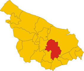
Mesagne
- Italian comune
Hiking in Mesagne
Mesagne, located in the Apulia region of Italy, is not typically known as a primary hiking destination like some of the larger national parks or mountainous areas, but it offers a unique opportunity for those interested in exploring the picturesque landscapes of the Salento region....
- Country:
- Postal Code: 72023
- Local Dialing Code: 0831
- Licence Plate Code: BR
- Coordinates: 40° 34' 0" N, 17° 48' 0" E
- GPS tracks (wikiloc): [Link]
- AboveSeaLevel: 72 м m
- Area: 124.05 sq km
- Population: 26836
- Web site: [Link]

Ostuni
- Italian comune
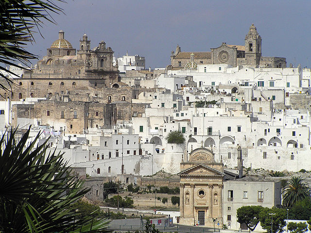
Hiking in Ostuni
Hiking in Ostuni, a picturesque town in the Apulia region of Italy, offers a unique blend of stunning landscapes, rich history, and beautiful Mediterranean climate. Here's what you can expect when hiking in this area:...
- Country:
- Postal Code: 72017
- Local Dialing Code: 0831
- Licence Plate Code: BR
- Coordinates: 40° 43' 56" N, 17° 34' 40" E
- GPS tracks (wikiloc): [Link]
- AboveSeaLevel: 207 м m
- Area: 225.56 sq km
- Population: 31197
- Web site: [Link]
San Michele Salentino
- Italian comune
Hiking in San Michele Salentino
San Michele Salentino is a charming town located in the Apulia (Puglia) region of Italy, known for its picturesque landscapes, historical sites, and traditional olive groves. While it may not be as famous for hiking as other regions in Italy, it offers some lovely opportunities for walking and exploring the countryside....
- Country:
- Postal Code: 72018
- Local Dialing Code: 0831
- Licence Plate Code: BR
- Coordinates: 40° 38' 0" N, 17° 38' 0" E
- GPS tracks (wikiloc): [Link]
- AboveSeaLevel: 153 м m
- Area: 26.53 sq km
- Population: 6258
- Web site: [Link]