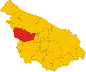
San Michele Salentino (San Michele Salentino)
.svg)
- Italian comune
 Hiking in San Michele Salentino
San Michele Salentino is a charming town located in the Apulia (Puglia) region of Italy, known for its picturesque landscapes, historical sites, and traditional olive groves. While it may not be as famous for hiking as other regions in Italy, it offers some lovely opportunities for walking and exploring the countryside.
Hiking Opportunities:
-
Countryside Trails: The area around San Michele Salentino has numerous paths that weave through the beautiful Apulian landscape, featuring olive groves, vineyards, and rustic stone walls. Look for local trails that can lead you to scenic viewpoints and quaint rural areas.
-
Natural Reserves: Nearby natural reserves or parks, such as the "Murgia dei Trulli" or "Foresta Umbra," can provide more structured hiking options. These areas are characterized by unique flora and fauna, as well as stunning rock formations.
-
Historical Walks: Combine hiking with history by walking to nearby towns such as Ostuni (the White City) or Ceglie Messapica. These routes can often be quite rewarding, as they allow you to enjoy both nature and the rich cultural heritage of the region.
-
Coastal Walks: If you are willing to travel a bit further, the Adriatic coastline is a short drive away and offers beautiful coastal trails. Areas like the Parco Naturale Regionale Dune Costiere provide stunning views of the sea and opportunities for beach hikes.
Tips for Hiking in San Michele Salentino:
- Weather Considerations: The best times to hike in this region are during the spring (March to June) and fall (September to November) when the temperatures are mild.
- Gear Up: Wear appropriate hiking shoes and carry water, snacks, and sun protection, especially in warmer months.
- Trail Maps: It’s advisable to have a map or a GPS device since some trails may not be well-marked.
- Local Guides: Consider joining a local hiking group or finding a guide who can provide insights into the area’s natural and cultural significance.
- Respect Nature: Follow the Leave No Trace principles to keep the environment pristine for future hikers.
In summary, while San Michele Salentino might not be a well-known hiking destination, it offers a unique blend of tranquility, natural beauty, and cultural exploration, making it a delightful place for hikers looking to experience the charm of rural Italy.
- Country:

- Postal Code: 72018
- Local Dialing Code: 0831
- Licence Plate Code: BR
- Coordinates: 40° 38' 0" N, 17° 38' 0" E


- GPS tracks (wikiloc): [Link]
- AboveSeaLevel: 153 м m
- Area: 26.53 sq km
- Population: 6258
- Web site: http://www.comune.sanmichelesal.br.it/
- Wikipedia en: wiki(en)
- Wikipedia: wiki(it)
- Wikidata storage: Wikidata: Q51874
- Wikipedia Commons Category: [Link]
- Freebase ID: [/m/0f5l6m]
- GeoNames ID: Alt: [6540752]
- OSM relation ID: [40615]
- MusicBrainz area ID: [b0349b66-80ea-46f1-b392-302d1ef67929]
- WOEID: [722914]
- ISTAT ID: 074014
- Italian cadastre code: I045
Shares border with regions:


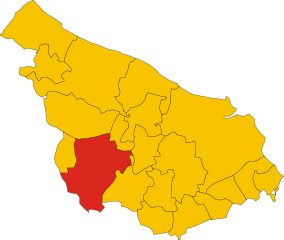
Carovigno
- Italian comune
Hiking in Carovigno
Carovigno, a charming town in the Apulia region of southern Italy, offers a wonderful backdrop for hiking enthusiasts. Nestled along the Adriatic coast, it sits about 20 kilometers north of Brindisi and is surrounded by a mix of rugged coastline, olive groves, and picturesque countryside....
- Country:
- Postal Code: 72012
- Local Dialing Code: 0831
- Licence Plate Code: BR
- Coordinates: 40° 42' 26" N, 17° 39' 34" E
- GPS tracks (wikiloc): [Link]
- AboveSeaLevel: 172 м m
- Area: 106.62 sq km
- Population: 17120
- Web site: [Link]

Ceglie Messapica
- Italian comune
Hiking in Ceglie Messapica
Ceglie Messapica, located in the Apulia region of Italy, is a charming destination known for its rich history, stunning landscapes, and beautiful countryside, making it a great spot for hiking enthusiasts. Here are some highlights about hiking in the area:...
- Country:
- Postal Code: 72013
- Local Dialing Code: 0831
- Licence Plate Code: BR
- Coordinates: 40° 39' 0" N, 17° 31' 0" E
- GPS tracks (wikiloc): [Link]
- AboveSeaLevel: 298 м m
- Area: 132.02 sq km
- Population: 19833
- Web site: [Link]

Francavilla Fontana
- Italian comune
Hiking in Francavilla Fontana
Francavilla Fontana is a town in the Apulia region of southern Italy, rich in history and culture, and surrounded by beautiful natural landscapes that can provide a great hiking experience. While Francavilla Fontana itself is more known for its architecture and historical sites, its surrounding areas offer opportunities for outdoor activities....
- Country:
- Postal Code: 72021
- Local Dialing Code: 0831
- Licence Plate Code: BR
- Coordinates: 40° 31' 53" N, 17° 35' 9" E
- GPS tracks (wikiloc): [Link]
- AboveSeaLevel: 142 м m
- Area: 177.94 sq km
- Population: 36358
- Web site: [Link]

Latiano
- Italian comune
Hiking in Latiano
Latiano, a charming town located in the Apulia region of southern Italy, is surrounded by a landscape that offers some potential for hiking and outdoor activities. While it may not be a well-known hiking destination, there are several options to explore the natural beauty and historical sites in the area....
- Country:
- Postal Code: 72022
- Local Dialing Code: 0831
- Licence Plate Code: BR
- Coordinates: 40° 32' 0" N, 17° 43' 0" E
- GPS tracks (wikiloc): [Link]
- AboveSeaLevel: 97 м m
- Area: 54.78 sq km
- Population: 14403
- Web site: [Link]
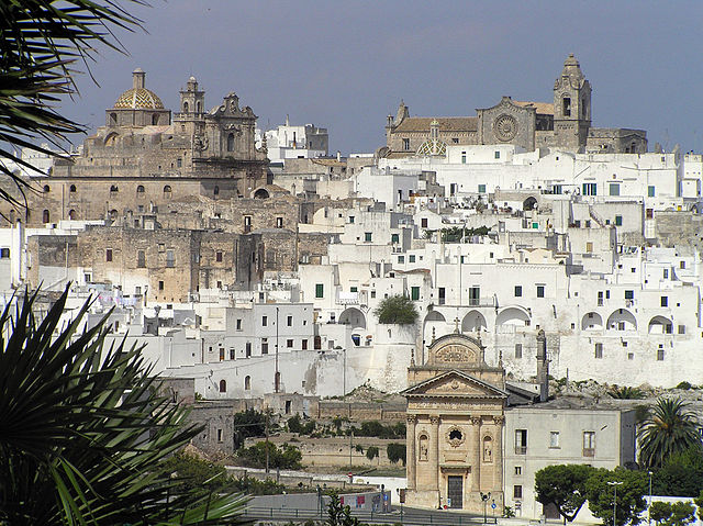

Ostuni
- Italian comune
Hiking in Ostuni
Hiking in Ostuni, a picturesque town in the Apulia region of Italy, offers a unique blend of stunning landscapes, rich history, and beautiful Mediterranean climate. Here's what you can expect when hiking in this area:...
- Country:
- Postal Code: 72017
- Local Dialing Code: 0831
- Licence Plate Code: BR
- Coordinates: 40° 43' 56" N, 17° 34' 40" E
- GPS tracks (wikiloc): [Link]
- AboveSeaLevel: 207 м m
- Area: 225.56 sq km
- Population: 31197
- Web site: [Link]


San Vito dei Normanni
- Italian comune
Hiking in San Vito dei Normanni
San Vito dei Normanni, located in the Apulia region of southern Italy, is a charming town known for its beautiful landscapes, rich history, and traditional architecture. While it may not be as famous for hiking as some other regions in Italy, there are still opportunities for outdoor enthusiasts to explore the surrounding countryside and enjoy the natural beauty of the area....
- Country:
- Postal Code: 72019
- Local Dialing Code: 0831
- Licence Plate Code: BR
- Coordinates: 40° 39' 20" N, 17° 42' 13" E
- GPS tracks (wikiloc): [Link]
- AboveSeaLevel: 108 м m
- Area: 67.08 sq km
- Population: 19095
- Web site: [Link]