Ottrott (Ottrott)

- commune in Bas-Rhin, France
- Country:

- Postal Code: 67530
- Coordinates: 48° 27' 28" N, 7° 25' 32" E


- GPS tracks (wikiloc): [Link]
- Area: 28.89 sq km
- Population: 1551
- Web site: http://www.ottrott.fr
- Wikipedia en: wiki(en)
- Wikipedia: wiki(fr)
- Wikidata storage: Wikidata: Q22434
- Wikipedia Commons Category: [Link]
- Freebase ID: [/m/03m9b1q]
- Freebase ID: [/m/03m9b1q]
- GeoNames ID: Alt: [2989082]
- GeoNames ID: Alt: [2989082]
- SIREN number: [216703686]
- SIREN number: [216703686]
- BnF ID: [15271510k]
- BnF ID: [15271510k]
- VIAF ID: Alt: [233775707]
- VIAF ID: Alt: [233775707]
- GND ID: Alt: [4236465-6]
- GND ID: Alt: [4236465-6]
- PACTOLS thesaurus ID: [pcrt706m4O0Oey]
- PACTOLS thesaurus ID: [pcrt706m4O0Oey]
- INSEE municipality code: 67368
- INSEE municipality code: 67368
Shares border with regions:


Bernardswiller
- commune in Bas-Rhin, France
- Country:
- Postal Code: 67210
- Coordinates: 48° 27' 12" N, 7° 27' 52" E
- GPS tracks (wikiloc): [Link]
- Area: 5.53 sq km
- Population: 1460
- Web site: [Link]


Neuviller-la-Roche
- commune in Bas-Rhin, France
- Country:
- Postal Code: 67130
- Coordinates: 48° 26' 0" N, 7° 14' 0" E
- GPS tracks (wikiloc): [Link]
- Area: 9.19 sq km
- Population: 358
- Web site: [Link]


Saint-Nabor
- commune in Bas-Rhin, France
- Country:
- Postal Code: 67530
- Coordinates: 48° 26' 43" N, 7° 25' 25" E
- GPS tracks (wikiloc): [Link]
- Area: 1.89 sq km
- Population: 480
- Web site: [Link]


Grendelbruch
- commune in Bas-Rhin, France
- Country:
- Postal Code: 67190
- Coordinates: 48° 29' 33" N, 7° 19' 22" E
- GPS tracks (wikiloc): [Link]
- Area: 14.63 sq km
- Population: 1233

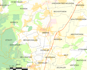
Obernai
- commune in Bas-Rhin, France
- Country:
- Postal Code: 67210
- Coordinates: 48° 27' 44" N, 7° 28' 55" E
- GPS tracks (wikiloc): [Link]
- Area: 25.74 sq km
- Population: 10751
- Web site: [Link]

Barr
- commune in Bas-Rhin, France
- Country:
- Postal Code: 67140
- Coordinates: 48° 24' 29" N, 7° 26' 59" E
- GPS tracks (wikiloc): [Link]
- Area: 20.61 sq km
- Population: 7246

Bœrsch
- commune in Bas-Rhin, France
- Country:
- Postal Code: 67530
- Coordinates: 48° 28' 38" N, 7° 26' 27" E
- GPS tracks (wikiloc): [Link]
- AboveSeaLevel: 499 м m
- Area: 23.39 sq km
- Population: 2436
- Web site: [Link]


Le Hohwald
- commune in Bas-Rhin, France
- Country:
- Postal Code: 67140
- Coordinates: 48° 24' 16" N, 7° 19' 46" E
- GPS tracks (wikiloc): [Link]
- Area: 20.84 sq km
- Population: 500
- Web site: [Link]