Palazzolo sull'Oglio (Palazzolo sull'Oglio)
.svg)
- Italian comune
 Hiking in Palazzolo sull'Oglio
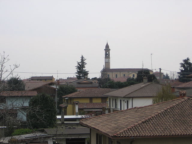
Palazzolo sull'Oglio is a charming town in the Lombardy region of Italy, located along the Oglio River. While it may not be as widely recognized as a hiking destination compared to the nearby mountains and lakes, it offers some pleasant walking and hiking opportunities in the surrounding areas. Here are some things to consider for hiking in and around Palazzolo sull'Oglio:
Hiking Trails
-
Oglio River Path: This is a scenic route that follows the banks of the Oglio River. It provides an easy-going trail suitable for all levels and is perfect for a leisurely walk, cycling, or running while enjoying the natural beauty.
-
Parco del Oglio Nord: Located nearby, this natural park offers various trails that wind through the forests and along the river. It’s an excellent spot for nature enthusiasts and bird watchers.
-
Surrounding Hills and Countryside: The area around Palazzolo sull'Oglio features rolling hills and agricultural landscapes, allowing for a more rustic hiking experience. Smaller trails can be found in these regions, connecting various rural paths.
Tips for Hiking
-
Best Time to Hike: Spring and autumn offer the most pleasant weather for hiking in this area. Summers can be warm, while winters may bring cold temperatures and snow, limiting trail access.
-
Preparation: Always wear comfortable hiking shoes, bring water, and consider a map or GPS device, as some areas may not be well-marked.
-
Local Attractions: After a day of hiking, take some time to explore Palazzolo sull'Oglio’s historical sites, such as the Church of San Giovanni Battista and other local landmarks.
Nearby Hiking Areas
If you are willing to travel a bit further, consider exploring the nearby Alps and the Dolomites, which offer more challenging hiking experiences and more spectacular scenery.
In summary, while Palazzolo sull'Oglio itself may not be a prominent hiking destination, it serves as a lovely hub for enjoying nature walks and exploring the beautiful countryside of Lombardy.
- Country:

- Postal Code: 25036
- Local Dialing Code: 030
- Licence Plate Code: BS
- Coordinates: 45° 36' 0" N, 9° 53' 0" E


- GPS tracks (wikiloc): [Link]
- AboveSeaLevel: 170 м m
- Area: 23.04 sq km
- Population: 20026
- Web site: http://www.comune.palazzolosulloglio.bs.it
- Wikipedia en: wiki(en)
- Wikipedia: wiki(it)
- Wikidata storage: Wikidata: Q111353
- Wikipedia Commons Gallery: [Link]
- Wikipedia Commons Category: [Link]
- Freebase ID: [/m/045dl0]
- GeoNames ID: Alt: [6541425]
- VIAF ID: Alt: [240526058]
- OSM relation ID: [45337]
- MusicBrainz area ID: [8dd2e615-d521-4b46-9255-359861985109]
- TGN ID: [1045849]
- UN/LOCODE: [ITPSO]
- Gran Enciclopèdia Catalana ID: [0048518]
- ISTAT ID: 017133
- Italian cadastre code: G264
Shares border with regions:
Castelli Calepio
- Italian comune
Hiking in Castelli Calepio
Castelli Calepio is a charming area located in the province of Bergamo, Northern Italy, known for its beautiful landscapes that blend hills, vineyards, and natural reserves. Hiking in this region offers a great opportunity to experience the stunning scenery and the rich cultural heritage of the area....
- Country:
- Postal Code: 24060
- Local Dialing Code: 035
- Licence Plate Code: BG
- Coordinates: 45° 38' 0" N, 9° 54' 0" E
- GPS tracks (wikiloc): [Link]
- AboveSeaLevel: 259 м m
- Area: 10.15 sq km
- Population: 10453
- Web site: [Link]


Grumello del Monte
- Italian comune
Hiking in Grumello del Monte
Grumello del Monte, located in Lombardy, Italy, is a great destination for hiking enthusiasts. Nestled between the city of Bergamo and the lush hills, it offers a mix of scenic trails, beautiful landscapes, and a chance to experience the local culture. Here’s what you need to know about hiking in the area:...
- Country:
- Postal Code: 24064
- Local Dialing Code: 035
- Licence Plate Code: BG
- Coordinates: 45° 38' 0" N, 9° 52' 0" E
- GPS tracks (wikiloc): [Link]
- AboveSeaLevel: 208 м m
- Area: 9.94 sq km
- Population: 7427
- Web site: [Link]

Palosco
- Italian comune
Hiking in Palosco
Palosco is a small town in the Lombardy region of Italy, located near the foothills of the Alps and within striking distance of a variety of natural landscapes. While it may not be as famous as other hiking destinations in Italy, it offers some beautiful trails and opportunities for outdoor activities....
- Country:
- Postal Code: 24050
- Local Dialing Code: 035
- Licence Plate Code: BG
- Coordinates: 45° 35' 0" N, 9° 50' 0" E
- GPS tracks (wikiloc): [Link]
- AboveSeaLevel: 157 м m
- Area: 10.79 sq km
- Population: 5808
- Web site: [Link]


Telgate
- Italian comune
Hiking in Telgate
Telgate is a charming town located in the Lombardy region of Italy, nestled in the hills near Lake Iseo and the Orobian Alps. While it may not be as widely known as some larger hiking destinations, it offers a variety of outdoor activities, including hiking trails that cater to different skill levels....
- Country:
- Postal Code: 24060
- Local Dialing Code: 035
- Licence Plate Code: BG
- Coordinates: 45° 38' 0" N, 9° 51' 0" E
- GPS tracks (wikiloc): [Link]
- AboveSeaLevel: 191 м m
- Area: 8.3 sq km
- Population: 5040
- Web site: [Link]

Adro
- Italian comune
Hiking in Adro
Adro, located in the province of Brescia in northern Italy, is not as widely known as some other hiking destinations, but it offers beautiful landscapes and opportunities for outdoor activities....
- Country:
- Postal Code: 25030
- Local Dialing Code: 030
- Licence Plate Code: BS
- Coordinates: 45° 37' 4" N, 9° 57' 45" E
- GPS tracks (wikiloc): [Link]
- AboveSeaLevel: 271 м m
- Area: 14 sq km
- Population: 7140
- Web site: [Link]

Capriolo
- Italian comune
Hiking in Capriolo
Capriolo, located in the province of Brescia in Lombardy, Italy, is a charming area that offers a range of hiking opportunities. The surrounding landscape is characterized by rolling hills, vineyards, and a blend of natural beauty and cultural heritage. Here are some highlights and tips for hiking in Capriolo:...
- Country:
- Postal Code: 25031
- Local Dialing Code: 030
- Licence Plate Code: BS
- Coordinates: 45° 38' 0" N, 9° 55' 55" E
- GPS tracks (wikiloc): [Link]
- AboveSeaLevel: 218 м m
- Area: 13 sq km
- Population: 9467
- Web site: [Link]

Chiari
- Italian comune
Hiking in Chiari
Chiari, located in the province of Brescia in Lombardy, Italy, is not only known for its charming historic center but also for its access to beautiful natural landscapes that are ideal for hiking enthusiasts. The surrounding area offers various trails and paths that cater to different skill levels, making it a great destination for both beginners and experienced hikers....
- Country:
- Postal Code: 25032
- Local Dialing Code: 030
- Licence Plate Code: BS
- Coordinates: 45° 31' 11" N, 9° 53' 0" E
- GPS tracks (wikiloc): [Link]
- AboveSeaLevel: 145 м m
- Area: 38.02 sq km
- Population: 18944
- Web site: [Link]
Cologne
- Italian comune
Hiking in Cologne
Hiking in the region of Cologne (Colonia) in Lombardy, Italy, offers a unique experience filled with beautiful landscapes and historical sites. The area is known for its picturesque hills, valleys, and paths that wind through vineyards, forests, and charming villages. Here are some highlights to consider when hiking in this region:...
- Country:
- Postal Code: 25033
- Local Dialing Code: 030
- Licence Plate Code: BS
- Coordinates: 45° 34' 0" N, 9° 57' 0" E
- GPS tracks (wikiloc): [Link]
- AboveSeaLevel: 183 м m
- Area: 13.79 sq km
- Population: 7534
- Web site: [Link]

Erbusco
- Italian comune
Hiking in Erbusco
Erbusco is a charming town located in the province of Brescia in Lombardy, Italy, and it offers a variety of outdoor activities, including hiking. The surrounding areas are characterized by beautiful landscapes, vineyards, and the scenic hills that are part of the Franciacorta region, which is renowned for its sparkling wines....
- Country:
- Postal Code: 25030
- Local Dialing Code: 030
- Licence Plate Code: BS
- Coordinates: 45° 36' 0" N, 9° 58' 0" E
- GPS tracks (wikiloc): [Link]
- AboveSeaLevel: 236 м m
- Area: 16.24 sq km
- Population: 8631
- Web site: [Link]
Pontoglio
- Italian comune
Hiking in Pontoglio
Pontoglio is a quaint town located in the Lombardy region of Italy, near the Oglio River, which offers a variety of hiking opportunities in and around the area. Here are some key points about hiking in and around Pontoglio:...
- Country:
- Postal Code: 25037
- Local Dialing Code: 030
- Licence Plate Code: BS
- Coordinates: 45° 34' 0" N, 9° 51' 0" E
- GPS tracks (wikiloc): [Link]
- AboveSeaLevel: 155 м m
- Area: 11.09 sq km
- Population: 6887
- Web site: [Link]