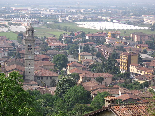
Telgate (Telgate)
.svg)
- Italian comune
 Hiking in Telgate
Telgate is a charming town located in the Lombardy region of Italy, nestled in the hills near Lake Iseo and the Orobian Alps. While it may not be as widely known as some larger hiking destinations, it offers a variety of outdoor activities, including hiking trails that cater to different skill levels.
Hiking Trails in and Around Telgate:
-
Local Trails:
- There are several local trails around Telgate that provide scenic views of the surrounding countryside, vineyards, and hills. These routes can be perfect for casual hikes and family outings.
-
Orobian Alps:
- Just a short drive away, the Orobian Alps offer a range of trails from easier walks to more challenging climbs. The area is known for its stunning landscapes, diverse flora and fauna, and well-maintained paths.
-
Lake Iseo:
- Hiking around Lake Iseo is a popular activity. The trails along the lake often lead to picturesque vistas and charming towns. The walk from Pisogne to Siviano provides beautiful views of the lake and its islands.
-
Sentiero dei Fiori:
- This well-known trail offers breathtaking views and a chance to experience local flora. It connects different parts of the region and can be tailored to various skill levels.
-
Cultural Hiking:
- Many trails are interspersed with historical sites, including old churches, rural farms, and remnants of ancient structures, making the experience not just about nature but also a cultural exploration.
Tips for Hiking in Telgate:
- Map and Navigation: Always carry a map or use a GPS app, as some trails may not be well-marked.
- Weather Awareness: Check weather conditions before heading out, as they can change quickly, especially in mountainous areas.
- Proper Gear: Invest in a good pair of hiking boots and take appropriate clothing based on the season. A backpack with snacks, water, and a first aid kit is also essential.
- Respect Nature: Stick to marked trails to preserve the local ecosystem and always follow the “Leave No Trace” principles to keep the area clean.
Accessibility:
Telgate is reachable by public transport from larger cities like Bergamo or Brescia, making it a convenient destination for day hikes.
In summary, hiking in Telgate offers a wonderful opportunity to explore the natural beauty and cultural heritage of the Lombardy region. Whether you're a seasoned hiker or a beginner, there are trails for everyone to enjoy.
- Country:

- Postal Code: 24060
- Local Dialing Code: 035
- Licence Plate Code: BG
- Coordinates: 45° 38' 0" N, 9° 51' 0" E


- GPS tracks (wikiloc): [Link]
- AboveSeaLevel: 191 м m
- Area: 8.3 sq km
- Population: 5040
- Web site: http://www.comune.telgate.bg.it
- Wikipedia en: wiki(en)
- Wikipedia: wiki(it)
- Wikidata storage: Wikidata: Q101648
- Wikipedia Commons Gallery: [Link]
- Wikipedia Commons Category: [Link]
- Freebase ID: [/m/0gjf7c]
- GeoNames ID: Alt: [6536156]
- VIAF ID: Alt: [245907417]
- OSM relation ID: [45475]
- UN/LOCODE: [ITTEL]
- Digital Atlas of the Roman Empire ID: [17144]
- Pleiades ID: [383796]
- ISTAT ID: 016212
- Italian cadastre code: L087
Shares border with regions:

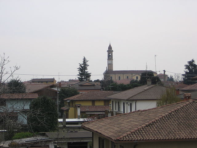
Chiuduno
- Italian comune
Hiking in Chiuduno
Chiuduno is a small town in the province of Bergamo in Lombardy, Italy. Surrounded by beautiful landscapes and located near the foothills of the Alps, it offers a variety of hiking opportunities for all levels of hikers. Here are some highlights and tips for hiking in and around Chiuduno:...
- Country:
- Postal Code: 24060
- Local Dialing Code: 035
- Licence Plate Code: BG
- Coordinates: 45° 39' 0" N, 9° 51' 0" E
- GPS tracks (wikiloc): [Link]
- AboveSeaLevel: 218 м m
- Area: 6.88 sq km
- Population: 6037
- Web site: [Link]


Grumello del Monte
- Italian comune
Hiking in Grumello del Monte
Grumello del Monte, located in Lombardy, Italy, is a great destination for hiking enthusiasts. Nestled between the city of Bergamo and the lush hills, it offers a mix of scenic trails, beautiful landscapes, and a chance to experience the local culture. Here’s what you need to know about hiking in the area:...
- Country:
- Postal Code: 24064
- Local Dialing Code: 035
- Licence Plate Code: BG
- Coordinates: 45° 38' 0" N, 9° 52' 0" E
- GPS tracks (wikiloc): [Link]
- AboveSeaLevel: 208 м m
- Area: 9.94 sq km
- Population: 7427
- Web site: [Link]

Palosco
- Italian comune
Hiking in Palosco
Palosco is a small town in the Lombardy region of Italy, located near the foothills of the Alps and within striking distance of a variety of natural landscapes. While it may not be as famous as other hiking destinations in Italy, it offers some beautiful trails and opportunities for outdoor activities....
- Country:
- Postal Code: 24050
- Local Dialing Code: 035
- Licence Plate Code: BG
- Coordinates: 45° 35' 0" N, 9° 50' 0" E
- GPS tracks (wikiloc): [Link]
- AboveSeaLevel: 157 м m
- Area: 10.79 sq km
- Population: 5808
- Web site: [Link]

Palazzolo sull'Oglio
- Italian comune
Hiking in Palazzolo sull'Oglio
Palazzolo sull'Oglio is a charming town in the Lombardy region of Italy, located along the Oglio River. While it may not be as widely recognized as a hiking destination compared to the nearby mountains and lakes, it offers some pleasant walking and hiking opportunities in the surrounding areas. Here are some things to consider for hiking in and around Palazzolo sull'Oglio:...
- Country:
- Postal Code: 25036
- Local Dialing Code: 030
- Licence Plate Code: BS
- Coordinates: 45° 36' 0" N, 9° 53' 0" E
- GPS tracks (wikiloc): [Link]
- AboveSeaLevel: 170 м m
- Area: 23.04 sq km
- Population: 20026
- Web site: [Link]


Bolgare
- Italian comune
Hiking in Bolgare
Bolgare is a small town in the province of Bergamo, Lombardy, Italy. Nestled in a beautiful region that offers access to the stunning landscapes of the Italian Alps, Bolgare is a great starting point for various hiking adventures....
- Country:
- Postal Code: 24060
- Local Dialing Code: 035
- Licence Plate Code: BG
- Coordinates: 45° 38' 3" N, 9° 49' 1" E
- GPS tracks (wikiloc): [Link]
- AboveSeaLevel: 199 м m
- Area: 8.59 sq km
- Population: 6183
- Web site: [Link]