
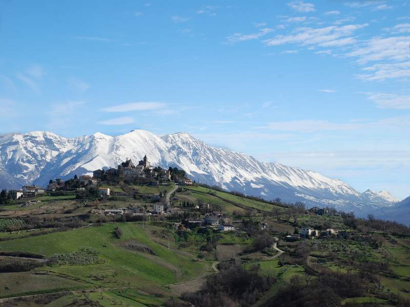
Pescosansonesco (Pescosansonesco)
.svg)
- Italian comune
 Hiking in Pescosansonesco
Pescosansonesco is a charming village located in the Abruzzo region of Italy, nestled in the mountains of the Gran Sasso and Monti della Laga National Park. This area is known for its stunning natural landscapes, making it a fantastic destination for hiking enthusiasts.
Hiking Opportunities
-
Scenic Trails: There are several trails in and around Pescosansonesco that offer a variety of experiences, from easy walks to more challenging hikes. The trails often lead through beautiful forests, past mountain streams, and to panoramic viewpoints.
-
Gran Sasso National Park: This nearby park is a top hiking destination, featuring rugged peaks, diverse flora and fauna, and breathtaking vistas. Hiking trails range in difficulty, catering to both beginners and experienced hikers.
-
Historic Paths: Some trails may take you past historical sites, such as old rural houses (known as “maisonnette”), ancient stone churches, and remnants of past agricultural activities, giving you a glimpse into the region's history.
-
Wildlife Watching: The Abruzzo region is home to various wildlife, including wolves, bears, and numerous bird species. Hiking in this area offers opportunities to observe these animals in their natural habitat.
Practical Tips
-
Best Time to Hike: The ideal time to hike in Pescosansonesco and the surrounding areas is during spring (April to June) and fall (September to October), when the weather is mild and the landscapes are vibrant.
-
Gear: Ensure you have appropriate hiking gear, including sturdy footwear, clothing suited for changeable weather, and plenty of water and snacks.
-
Maps and Guides: It's advisable to have a map or a GPS device, as some trails may not be well-marked. Local visitor centers often have helpful resources.
-
Local Guidance: If you’re unfamiliar with hiking in this kind of terrain, consider hiring a local guide who can offer insights into the best trails and ensure your safety.
Local Culture and Cuisine
After a day of hiking, you can enjoy the local cuisine in Pescosansonesco. The area is known for its traditional Abruzzo dishes, including pasta, meat dishes, and regional cheeses that are well worth trying.
Overall, hiking in Pescosansonesco can be a rewarding experience, combining the beauty of nature with the cultural richness of the Abruzzo region.
- Country:

- Postal Code: 65020
- Local Dialing Code: 085
- Licence Plate Code: PE
- Coordinates: 42° 15' 0" N, 13° 53' 0" E


- GPS tracks (wikiloc): [Link]
- AboveSeaLevel: 550 м m
- Area: 18.35 sq km
- Population: 497
- Web site: http://www.pescosansonesco.net/
- Wikipedia en: wiki(en)
- Wikipedia: wiki(it)
- Wikidata storage: Wikidata: Q51377
- Wikipedia Commons Category: [Link]
- Freebase ID: [/m/0fg8s4]
- GeoNames ID: Alt: [6542035]
- VIAF ID: Alt: [158731816]
- OSM relation ID: [41902]
- Library of Congress authority ID: Alt: [nr98011445]
- ISTAT ID: 068029
- Italian cadastre code: G499
Shares border with regions:


Capestrano
- Italian comune
Hiking in Capestrano
Capestrano, a picturesque village located in the Abruzzo region of Italy, offers hikers a unique blend of natural beauty, historical sites, and cultural experiences. Here are some key points about hiking in Capestrano:...
- Country:
- Postal Code: 67022
- Local Dialing Code: 0862
- Licence Plate Code: AQ
- Coordinates: 42° 16' 10" N, 13° 46' 0" E
- GPS tracks (wikiloc): [Link]
- AboveSeaLevel: 465 м m
- Area: 43.66 sq km
- Population: 897
- Web site: [Link]


Bussi sul Tirino
- Italian comune
Hiking in Bussi sul Tirino
Bussi sul Tirino is a picturesque town located in the Abruzzo region of Italy, nestled along the Tirino River and surrounded by beautiful mountainous landscapes. This area offers a variety of hiking opportunities, catering to both novice and experienced hikers. Here are some highlights to consider when planning your hiking adventure in Bussi sul Tirino:...
- Country:
- Postal Code: 65022
- Local Dialing Code: 085
- Licence Plate Code: PE
- Coordinates: 42° 13' 0" N, 13° 49' 0" E
- GPS tracks (wikiloc): [Link]
- AboveSeaLevel: 344 м m
- Area: 25.91 sq km
- Population: 2447
- Web site: [Link]


Castiglione a Casauria
- Italian comune
Hiking in Castiglione a Casauria
Castiglione a Casauria is a picturesque village located in the Abruzzo region of Italy, nestled in the foothills of the Apennines. The area is known for its stunning natural landscapes, historical sites, and outdoor activities, making it a great destination for hiking enthusiasts....
- Country:
- Postal Code: 65020
- Local Dialing Code: 085
- Licence Plate Code: PE
- Coordinates: 42° 14' 13" N, 13° 53' 54" E
- GPS tracks (wikiloc): [Link]
- AboveSeaLevel: 350 м m
- Area: 16.57 sq km
- Population: 802
- Web site: [Link]
Corvara
- Italian comune
Hiking in Corvara
Corvara, located in the Abruzzo region of Italy, is a fantastic destination for hiking enthusiasts. Nestled in a picturesque valley surrounded by the stunning Gran Sasso and Monti della Laga National Park, the area offers a wide variety of trails that cater to all levels of hikers, from beginners to experienced mountaineers....
- Country:
- Postal Code: 65020
- Local Dialing Code: 085
- Licence Plate Code: PE
- Coordinates: 42° 16' 31" N, 13° 52' 25" E
- GPS tracks (wikiloc): [Link]
- AboveSeaLevel: 625 м m
- Area: 13.73 sq km
- Population: 232

Pietranico
- Italian comune
Hiking in Pietranico
Pietranico is a small village located in the Abruzzo region of Italy, surrounded by stunning natural landscapes that are perfect for hiking enthusiasts. Nestled in the foothills of the Gran Sasso mountain range, Pietranico offers a variety of trails suitable for different skill levels, from leisurely walks to more challenging hikes....
- Country:
- Postal Code: 65020
- Local Dialing Code: 085
- Licence Plate Code: PE
- Coordinates: 42° 17' 0" N, 13° 55' 0" E
- GPS tracks (wikiloc): [Link]
- AboveSeaLevel: 590 м m
- Area: 14.77 sq km
- Population: 477
- Web site: [Link]