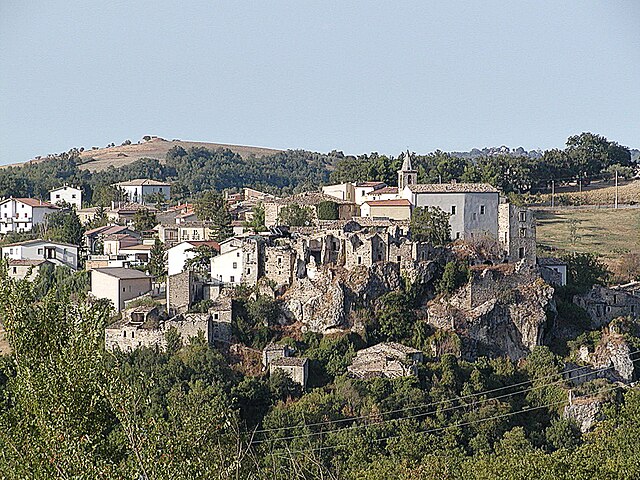
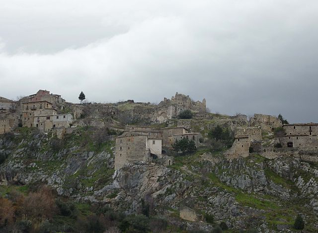
Castiglione a Casauria (Castiglione a Casauria)
.svg)
- Italian comune
 Hiking in Castiglione a Casauria
Castiglione a Casauria is a picturesque village located in the Abruzzo region of Italy, nestled in the foothills of the Apennines. The area is known for its stunning natural landscapes, historical sites, and outdoor activities, making it a great destination for hiking enthusiasts.
Hiking Trails and Areas
-
Gran Sasso and Monti della Laga National Park: Just a short distance from Castiglione a Casauria, this national park offers numerous hiking trails ranging from easy walks to challenging climbs. Trails in this park provide opportunities to see diverse flora and fauna as well as breathtaking mountain views.
-
Local Trails: The area surrounding Castiglione a Casauria features a variety of local trails, often less crowded and offering a more intimate way to experience the region's natural beauty. You can explore different paths that lead through forests, meadows, and valleys, with stopping points that often feature beautiful vistas and historical sites.
-
The Abbey of San Clemente a Casauria: While not a hiking trail per se, this historic site can be included in a hike or walk through the region. The abbey has a rich history dating back to the 9th century and provides a beautiful backdrop to your outdoor explorations.
Hiking Tips
- Trail Maps: Always check for the latest trail maps and conditions before heading out. Many local hiking associations or tourist information centers can provide up-to-date information.
- Weather: The weather in the region can vary greatly. Be sure to dress in layers and check the forecast before setting off.
- Respect Nature: Stay on marked trails, take all trash with you, and respect wildlife and plants to preserve the natural beauty of the area.
Best Time to Hike
Spring and early fall are generally the best times for hiking in this region. During these seasons, you can enjoy comfortable temperatures and stunning wildflower displays in the spring or beautiful autumn foliage in the fall.
Local Culture and Cuisine
After a day of hiking, you can immerse yourself in the local culture. Castiglione a Casauria is known for its traditional Abruzzese cuisine, featuring dishes like arrosticini (skewered lamb) and homemade pasta. Visiting a local trattoria can be a fantastic way to relax and enjoy the region's flavors.
Whether you’re looking for a leisurely walk or an adventurous hike, the area around Castiglione a Casauria offers a variety of options to enjoy the stunning scenery and rich history of this beautiful part of Italy.
- Country:

- Postal Code: 65020
- Local Dialing Code: 085
- Licence Plate Code: PE
- Coordinates: 42° 14' 13" N, 13° 53' 54" E


- GPS tracks (wikiloc): [Link]
- AboveSeaLevel: 350 м m
- Area: 16.57 sq km
- Population: 802
- Web site: http://www.comune.castiglioneacasauria.pe.it/
- Wikipedia en: wiki(en)
- Wikipedia: wiki(it)
- Wikidata storage: Wikidata: Q51353
- Wikipedia Commons Category: [Link]
- Freebase ID: [/m/0fg8hp]
- GeoNames ID: Alt: [6537466]
- VIAF ID: Alt: [265360104]
- OSM relation ID: [41873]
- GND ID: Alt: [4698166-4]
- Library of Congress authority ID: Alt: [n85243720]
- WOEID: [713508]
- ISTAT ID: 068009
- Italian cadastre code: C308
Shares border with regions:

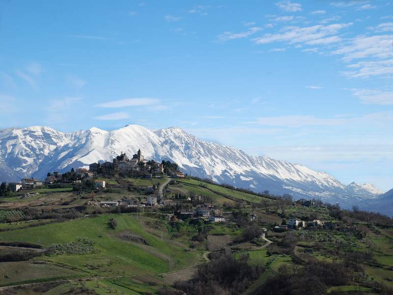
Bolognano
- Italian municipality
Hiking in Bolognano
Bolognano, a charming village in the Abruzzo region of Italy, is an excellent destination for hiking enthusiasts. Nestled in the foothills of the Apennines, it offers stunning landscapes, rich biodiversity, and a variety of trails suitable for different skill levels....
- Country:
- Postal Code: 65020
- Local Dialing Code: 085
- Licence Plate Code: PE
- Coordinates: 42° 13' 0" N, 13° 58' 0" E
- GPS tracks (wikiloc): [Link]
- AboveSeaLevel: 276 м m
- Area: 16.96 sq km
- Population: 1095
- Web site: [Link]


Bussi sul Tirino
- Italian comune
Hiking in Bussi sul Tirino
Bussi sul Tirino is a picturesque town located in the Abruzzo region of Italy, nestled along the Tirino River and surrounded by beautiful mountainous landscapes. This area offers a variety of hiking opportunities, catering to both novice and experienced hikers. Here are some highlights to consider when planning your hiking adventure in Bussi sul Tirino:...
- Country:
- Postal Code: 65022
- Local Dialing Code: 085
- Licence Plate Code: PE
- Coordinates: 42° 13' 0" N, 13° 49' 0" E
- GPS tracks (wikiloc): [Link]
- AboveSeaLevel: 344 м m
- Area: 25.91 sq km
- Population: 2447
- Web site: [Link]

Pescosansonesco
- Italian comune
Hiking in Pescosansonesco
Pescosansonesco is a charming village located in the Abruzzo region of Italy, nestled in the mountains of the Gran Sasso and Monti della Laga National Park. This area is known for its stunning natural landscapes, making it a fantastic destination for hiking enthusiasts....
- Country:
- Postal Code: 65020
- Local Dialing Code: 085
- Licence Plate Code: PE
- Coordinates: 42° 15' 0" N, 13° 53' 0" E
- GPS tracks (wikiloc): [Link]
- AboveSeaLevel: 550 м m
- Area: 18.35 sq km
- Population: 497
- Web site: [Link]

Pietranico
- Italian comune
Hiking in Pietranico
Pietranico is a small village located in the Abruzzo region of Italy, surrounded by stunning natural landscapes that are perfect for hiking enthusiasts. Nestled in the foothills of the Gran Sasso mountain range, Pietranico offers a variety of trails suitable for different skill levels, from leisurely walks to more challenging hikes....
- Country:
- Postal Code: 65020
- Local Dialing Code: 085
- Licence Plate Code: PE
- Coordinates: 42° 17' 0" N, 13° 55' 0" E
- GPS tracks (wikiloc): [Link]
- AboveSeaLevel: 590 м m
- Area: 14.77 sq km
- Population: 477
- Web site: [Link]


Tocco da Casauria
- Italian comune
Hiking in Tocco da Casauria
Tocco da Casauria is a charming village located in the Abruzzo region of Italy, nestled in the foothills of the Majella mountain range. This area is known for its stunning landscapes, rich history, and outdoor activities, including hiking. Here are some details about hiking in and around Tocco da Casauria:...
- Country:
- Postal Code: 65028
- Local Dialing Code: 085
- Licence Plate Code: PE
- Coordinates: 42° 13' 0" N, 13° 55' 0" E
- GPS tracks (wikiloc): [Link]
- AboveSeaLevel: 356 м m
- Area: 29.67 sq km
- Population: 2640
- Web site: [Link]


Torre de' Passeri
- Italian comune
Hiking in Torre de' Passeri
Torre de' Passeri is a picturesque town located in the Abruzzo region of Italy, nestled within the beautiful Apennine Mountains. Hiking in and around Torre de' Passeri offers a mix of scenic landscapes, cultural experiences, and opportunities to explore the natural beauty of the region....
- Country:
- Postal Code: 65029
- Local Dialing Code: 085
- Licence Plate Code: PE
- Coordinates: 42° 14' 0" N, 13° 56' 0" E
- GPS tracks (wikiloc): [Link]
- AboveSeaLevel: 172 м m
- Area: 5.92 sq km
- Population: 3045
- Web site: [Link]