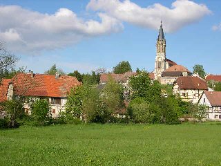
Pfetterhouse (Pfetterhouse)

- commune in Haut-Rhin, France
 Hiking in Pfetterhouse
Pfetterhouse is a charming village located in the Alsace region of France, near the border with Switzerland. While it may not be as widely known for hiking as some larger areas, it offers beautiful landscapes and a chance to enjoy the natural environment. Here are some insights into hiking in and around Pfetterhouse:
Trails and Routes
-
Local Trails: The region around Pfetterhouse features several local trails that take you through picturesque countryside, vineyards, and forests. You might find marked paths suitable for various levels of hikers.
-
Grand Randonée (GR Path): The GR5 long-distance trail runs near the area, which is part of a larger network of hiking paths across Europe. You can access segments of this trail to enjoy a more challenging hike.
-
Nearby Forests: The nearby Jura Mountains provide excellent hiking opportunities, including forest hikes that offer both shade and the chance to spot wildlife.
Highlights to See
- Scenic Views: Many trails offer stunning views of the surrounding valleys and the Jura Mountains.
- Cultural Landmarks: You can explore historical sites, such as traditional Alsatian villages, local churches, and vineyards along your hike.
Tips for Hikers
- Check Trail Maps: Before heading out, check local resources or tourist information for up-to-date maps and trail conditions.
- Prepare for Weather: The weather can change quickly in the mountains, so it's wise to dress in layers and carry rain gear.
- Bring Supplies: Carry enough water and snacks, especially if you plan on taking longer hikes.
- Wildlife and Nature: Be respectful of the environment, and take note of any local wildlife guidelines, as this area is home to diverse flora and fauna.
Conclusion
While Pfetterhouse may not be a major hiking hub, it provides access to beautiful landscapes and a chance to explore the charming Alsatian countryside. Whether you're looking for a leisurely walk or a more rigorous hike, you'll find the area rewarding. Happy hiking!
- Country:

- Postal Code: 68480
- Coordinates: 47° 30' 3" N, 7° 9' 59" E


- GPS tracks (wikiloc): [Link]
- Area: 14.28 sq km
- Population: 1019
- Wikipedia en: wiki(en)
- Wikipedia: wiki(fr)
- Wikidata storage: Wikidata: Q148099
- Wikipedia Commons Category: [Link]
- Freebase ID: [/m/027tr86]
- Freebase ID: [/m/027tr86]
- GeoNames ID: Alt: [2987428]
- GeoNames ID: Alt: [2987428]
- SIREN number: [216802579]
- SIREN number: [216802579]
- BnF ID: [152719591]
- BnF ID: [152719591]
- VIAF ID: Alt: [239026655]
- VIAF ID: Alt: [239026655]
- GND ID: Alt: [4103082-5]
- GND ID: Alt: [4103082-5]
- INSEE municipality code: 68257
- INSEE municipality code: 68257
Shares border with regions:


Liebsdorf
- commune in Haut-Rhin, France
Hiking in Liebsdorf
Liebsdorf is a small village located in the state of Baden-Württemberg, Germany. Although it may not be as well-known as some larger destinations, it offers a variety of scenic landscapes and hiking opportunities that can cater to different skill levels....
- Country:
- Postal Code: 68480
- Coordinates: 47° 28' 45" N, 7° 13' 51" E
- GPS tracks (wikiloc): [Link]
- Area: 4.22 sq km
- Population: 322


Mooslargue
- commune in Haut-Rhin, France
Hiking in Mooslargue
Mooslargue is a quaint village located in the Alsace region of northeastern France, close to the borders with Switzerland and Germany. It is surrounded by beautiful landscapes, making it an excellent destination for hiking enthusiasts. Here are some highlights of hiking in and around Mooslargue:...
- Country:
- Postal Code: 68580
- Coordinates: 47° 30' 35" N, 7° 13' 5" E
- GPS tracks (wikiloc): [Link]
- AboveSeaLevel: 425 м m
- Area: 5.63 sq km
- Population: 432


Courtavon
- commune in Haut-Rhin, France
Hiking in Courtavon
Courtavon is not widely recognized as a notable hiking destination, so it might be a less explored area. However, if you are interested in hiking in a particular region that includes this name, such as in certain parts of Europe, the experience can vary greatly based on the location....
- Country:
- Postal Code: 68480
- Coordinates: 47° 27' 38" N, 7° 11' 51" E
- GPS tracks (wikiloc): [Link]
- Area: 9.6 sq km
- Population: 370


Seppois-le-Bas
- commune in Haut-Rhin, France
Hiking in Seppois-le-Bas
Seppois-le-Bas, located in the Alsace region of France, offers a variety of hiking opportunities that showcase the beautiful landscapes and natural features of the area. While the village itself is small, it serves as a good starting point for exploring the surrounding countryside, including the nearby Jura Mountains and the picturesque landscapes of Alsace....
- Country:
- Postal Code: 68580
- Coordinates: 47° 32' 11" N, 7° 10' 28" E
- GPS tracks (wikiloc): [Link]
- Area: 6.73 sq km
- Population: 1338
- Web site: [Link]

Réchésy
- commune in Territoire de Belfort, France
Hiking in Réchésy
Réchésy is a small locality in the region of France, specifically in the Bourgogne-Franche-Comté area. While it may not be as widely known as some other hiking destinations, it is surrounded by beautiful landscapes and natural features that can appeal to hikers....
- Country:
- Postal Code: 90370
- Coordinates: 47° 30' 30" N, 7° 6' 47" E
- GPS tracks (wikiloc): [Link]
- Area: 12.61 sq km
- Population: 806
- Web site: [Link]


Seppois-le-Haut
- commune in Haut-Rhin, France
Hiking in Seppois-le-Haut
Seppois-le-Haut, located in the Alsace region of France, is known for its beautiful natural landscapes and hiking opportunities that cater to various skill levels. The area features lush forests, rolling hills, and scenic views of the surrounding countryside, making it an inviting destination for hikers....
- Country:
- Postal Code: 68580
- Coordinates: 47° 32' 0" N, 7° 11' 1" E
- GPS tracks (wikiloc): [Link]
- Area: 6.27 sq km
- Population: 488
- Web site: [Link]