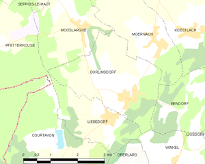
Mooslargue (Mooslargue)
- commune in Haut-Rhin, France
Mooslargue is a quaint village located in the Alsace region of northeastern France, close to the borders with Switzerland and Germany. It is surrounded by beautiful landscapes, making it an excellent destination for hiking enthusiasts. Here are some highlights of hiking in and around Mooslargue:
Scenic Trails
-
Vineyard and Forest Paths: The area offers a mix of vineyard trails and forest paths. The gentle rolling hills are perfect for leisurely hikes while enjoying the views of the vineyards and the hills of the Vosges mountains.
-
Biosphere Reserves: The nearby Doubs Valley, which is part of a UNESCO Biosphere Reserve, features lush vegetation and a variety of wildlife. Hiking through these reserves can provide opportunities for birdwatching and spotting local flora and fauna.
-
Cross-Border Hikes: Mooslargue's proximity to Switzerland and Germany allows for enjoyable cross-border hikes. You can explore trails in the nearby Jura mountains or venture into the Black Forest in Germany.
Difficulty Levels
The hiking trails around Mooslargue vary in difficulty, from easy, family-friendly routes to more challenging ascents for seasoned hikers. Most paths are well-marked and cater to hikers of all skill levels.
Access to Amenities
The village itself has some amenities for hikers, including guesthouses, local eateries, and information centers where you can get trail maps and advice on hiking routes.
Best Times to Hike
- Spring (April to June): Mild weather and blooming flora make this a lovely time to hike.
- Autumn (September to November): The fall foliage offers stunning views and great photo opportunities.
Preparation Tips
- Footwear: Wear sturdy hiking shoes or boots that can handle various terrain.
- Weather: Check the weather forecast before your hike, as conditions can change quickly, especially in mountainous areas.
- Supplies: Carry enough water, snacks, and sunscreen. It’s also a good idea to have a small first-aid kit.
Hiking in Mooslargue and its surrounding areas can be a delightful experience that combines natural beauty, cultural richness, and adventure. Be sure to respect the natural environment and follow local guidelines to ensure a safe and enjoyable outing.
- Country:

- Postal Code: 68580
- Coordinates: 47° 30' 35" N, 7° 13' 5" E


- GPS tracks (wikiloc): [Link]
- AboveSeaLevel: 425 м m
- Area: 5.63 sq km
- Population: 432
- Wikipedia en: wiki(en)
- Wikipedia: wiki(fr)
- Wikidata storage: Wikidata: Q148653
- Wikipedia Commons Category: [Link]
- Freebase ID: [/m/03m4l7v]
- Freebase ID: [/m/03m4l7v]
- GeoNames ID: Alt: [6617441]
- GeoNames ID: Alt: [6617441]
- SIREN number: [216802165]
- SIREN number: [216802165]
- BnF ID: [15271918f]
- BnF ID: [15271918f]
- INSEE municipality code: 68216
- INSEE municipality code: 68216
Shares border with regions:


Pfetterhouse
- commune in Haut-Rhin, France
Pfetterhouse is a charming village located in the Alsace region of France, near the border with Switzerland. While it may not be as widely known for hiking as some larger areas, it offers beautiful landscapes and a chance to enjoy the natural environment. Here are some insights into hiking in and around Pfetterhouse:...
- Country:

- Postal Code: 68480
- Coordinates: 47° 30' 3" N, 7° 9' 59" E


- GPS tracks (wikiloc): [Link]
- Area: 14.28 sq km
- Population: 1019


Moernach
- commune in Haut-Rhin, France
Mœrnach, a picturesque village in the Luxembourg Ardennes, offers beautiful hiking opportunities amidst lush landscapes, rolling hills, and dense forests. Here are some highlights to consider when hiking in this region:...
- Country:

- Postal Code: 68480
- Coordinates: 47° 30' 13" N, 7° 15' 19" E


- GPS tracks (wikiloc): [Link]
- Area: 6.79 sq km
- Population: 572


Bisel
- commune in Haut-Rhin, France
Bisel, a small town located in the Alsace region of France, offers a unique hiking experience with its picturesque landscapes and scenic trails. The area is characterized by its rolling hills, vineyards, and proximity to natural reserves, making it an attractive destination for outdoor enthusiasts....
- Country:

- Postal Code: 68580
- Coordinates: 47° 32' 7" N, 7° 13' 6" E


- GPS tracks (wikiloc): [Link]
- Area: 8.1 sq km
- Population: 540


Durlinsdorf
- commune in Haut-Rhin, France
Durlinsdorf is a charming village located in the Haut-Rhin department of France, near the borders with Switzerland and Germany. The area is known for its beautiful landscapes, lush forests, and the scenic surroundings of the Vosges Mountains, making it a wonderful destination for hiking enthusiasts....
- Country:

- Postal Code: 68480
- Coordinates: 47° 29' 9" N, 7° 14' 27" E


- GPS tracks (wikiloc): [Link]
- Area: 7.78 sq km
- Population: 569


Seppois-le-Haut
- commune in Haut-Rhin, France
Seppois-le-Haut, located in the Alsace region of France, is known for its beautiful natural landscapes and hiking opportunities that cater to various skill levels. The area features lush forests, rolling hills, and scenic views of the surrounding countryside, making it an inviting destination for hikers....
- Country:

- Postal Code: 68580
- Coordinates: 47° 32' 0" N, 7° 11' 1" E


- GPS tracks (wikiloc): [Link]
- Area: 6.27 sq km
- Population: 488
- Web site: [Link]

