Plappeville (Plappeville)

- commune in Moselle, France
- Country:

- Postal Code: 57050
- Coordinates: 49° 7' 50" N, 6° 7' 22" E


- GPS tracks (wikiloc): [Link]
- Area: 2.54 sq km
- Population: 2029
- Web site: http://www.communedeplappeville.fr
- Wikipedia en: wiki(en)
- Wikipedia: wiki(fr)
- Wikidata storage: Wikidata: Q22268
- Wikipedia Commons Category: [Link]
- Freebase ID: [/m/03qf36w]
- Freebase ID: [/m/03qf36w]
- GeoNames ID: Alt: [2986855]
- GeoNames ID: Alt: [2986855]
- SIREN number: [215705450]
- SIREN number: [215705450]
- BnF ID: [15266048w]
- BnF ID: [15266048w]
- VIAF ID: Alt: [247384663]
- VIAF ID: Alt: [247384663]
- GND ID: Alt: [4575477-9]
- GND ID: Alt: [4575477-9]
- WOEID: [12668301]
- WOEID: [12668301]
- INSEE municipality code: 57545
- INSEE municipality code: 57545
Shares border with regions:

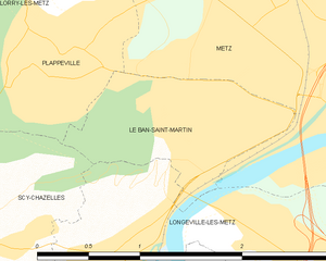
Le Ban-Saint-Martin
- commune in Moselle, France
- Country:
- Postal Code: 57050
- Coordinates: 49° 7' 19" N, 6° 9' 2" E
- GPS tracks (wikiloc): [Link]
- Area: 1.59 sq km
- Population: 4164
- Web site: [Link]


Lorry-lès-Metz
- commune in Moselle, France
- Country:
- Postal Code: 57050
- Coordinates: 49° 8' 30" N, 6° 7' 17" E
- GPS tracks (wikiloc): [Link]
- AboveSeaLevel: 240 м m
- Area: 6.09 sq km
- Population: 1749

Lessy
- commune in Moselle, France
- Country:
- Postal Code: 57160
- Coordinates: 49° 7' 11" N, 6° 5' 45" E
- GPS tracks (wikiloc): [Link]
- Area: 2.85 sq km
- Population: 746


Metz
- commune in Moselle, France
- Country:
- Postal Code: 57070; 57050; 57000
- Coordinates: 49° 7' 11" N, 6° 10' 37" E
- GPS tracks (wikiloc): [Link]
- AboveSeaLevel: 179 м m
- Area: 41.94 sq km
- Population: 117492
- Web site: [Link]


Scy-Chazelles
- commune in Moselle, France
- Country:
- Postal Code: 57160
- Coordinates: 49° 6' 49" N, 6° 6' 51" E
- GPS tracks (wikiloc): [Link]
- Area: 4.52 sq km
- Population: 2694
- Web site: [Link]