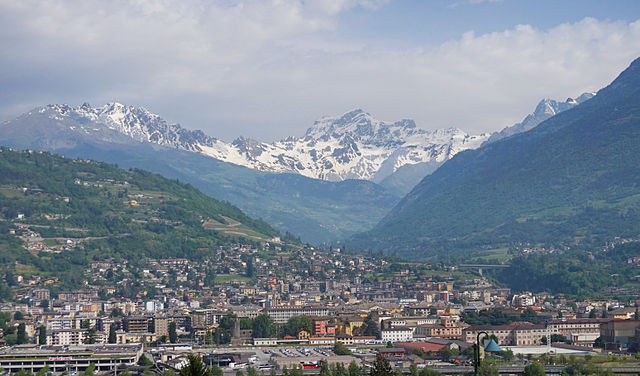
Pollein (Pollein)
.svg)
- Italian comune
 Hiking in Pollein
Pollein is a charming municipality located in the Aosta Valley region of Italy, surrounded by stunning Alpine scenery. It's known for its picturesque landscapes and offers various hiking opportunities suitable for different skill levels. Here’s an overview of what you can expect when hiking in and around Pollein:
Hiking Trails
-
Valle d'Aosta Trails: The area is dotted with numerous trails that connect with larger networks extending throughout the Aosta Valley. You can find well-marked paths that range from easy strolls to challenging hikes.
-
Monte Emilius: This is a popular destination for hikers looking for a moderate to challenging climb. The summit offers breathtaking views of the Aosta Valley. The trail is marked, but good physical condition is recommended.
-
Bard Fortress Trek: If you enjoy historical sites, the trek from Pollein to the nearby Bard Fortress is an excellent choice. The trail is not overly strenuous and allows you to explore the fortress and enjoy scenic views.
-
Nature Walks: For those looking for gentler hikes, many shorter, family-friendly trails can be found around Pollein, suitable for children or leisure walkers. Explore the local flora and fauna of the region.
Best Hiking Season
- Spring (May - June): The wildflowers bloom, and the weather is generally mild, making it a lovely time to hike.
- Summer (July - August): This is peak hiking season. Trails are often busy, but the weather is usually warm and conducive to longer hikes.
- Fall (September - October): The autumn colors add a beautiful backdrop for hikers. The temperatures are cooler, which can be refreshing for trekking.
- Winter (November - April): Snow hiking or snowshoeing can be enjoyed, but trails may be more challenging. Be sure to check for weather and trail conditions.
Safety Tips
- Equipment: Ensure you have proper hiking boots, ample water, snacks, and weather-appropriate clothing.
- Trail Conditions: Always check the conditions of the trail before heading out, as they can change due to weather.
- Navigational Aids: Use maps or GPS devices to stay on track, especially if you're venturing into less familiar areas.
Additional Considerations
- Guided Tours: If you’re new to hiking or would like to learn more about the area, consider hiring a local guide who can share insights about the natural surroundings and cultural history.
- Cultural Sites: In addition to the natural beauty, look for opportunities to explore local culture, including traditional villages, local cuisine, and historical landmarks.
Hiking in Pollein offers a rich experience combining the beauty of nature with cultural exploration. Whether you're a seasoned hiker or a beginner, there's something for everyone in this beautiful part of the Italian Alps.
- Country:

- Postal Code: 11020
- Local Dialing Code: 0165
- Licence Plate Code: AO
- Coordinates: 45° 43' 41" N, 7° 21' 25" E


- GPS tracks (wikiloc): [Link]
- AboveSeaLevel: 551 м m
- Area: 15.33 sq km
- Population: 1527
- Web site: http://www.comune.pollein.ao.it
- Wikipedia en: wiki(en)
- Wikipedia: wiki(it)
- Wikidata storage: Wikidata: Q35275
- Wikipedia Commons Gallery: [Link]
- Wikipedia Commons Category: [Link]
- Wikipedia Commons Maps Category: [Link]
- Freebase ID: [/m/0ft03v]
- GeoNames ID: Alt: [6536061]
- VIAF ID: Alt: [232955928]
- OSM relation ID: [45918]
- UN/LOCODE: [ITPOL]
- ISTAT ID: 007049
- Italian cadastre code: G794
Shares border with regions:

Aosta
- Italian comune
Hiking in Aosta
Aosta, the capital of the Aosta Valley in Italy, is a fantastic destination for hiking enthusiasts. Nestled in the Italian Alps, the region offers stunning landscapes, charming villages, and a mix of both easy and challenging hiking trails. Here are some key points to consider for hiking in Aosta:...
- Country:
- Postal Code: 11100
- Local Dialing Code: 0165
- Licence Plate Code: AO
- Coordinates: 45° 44' 14" N, 7° 19' 14" E
- GPS tracks (wikiloc): [Link]
- AboveSeaLevel: 583 м m
- Area: 21 sq km
- Population: 34324
- Web site: [Link]


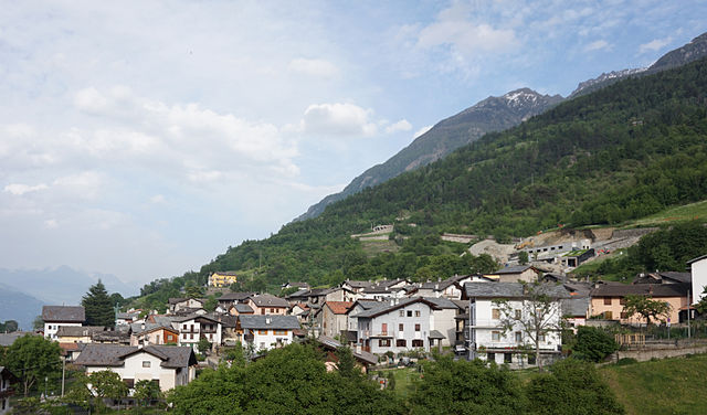
Brissogne
- Italian comune
Hiking in Brissogne
Brissogne is a charming small village located in the Aosta Valley region of Italy. It's known for its stunning natural scenery, including the surrounding mountains and lush landscapes, making it an excellent destination for hiking enthusiasts of all levels....
- Country:
- Postal Code: 11020
- Local Dialing Code: 0165
- Licence Plate Code: AO
- Coordinates: 45° 44' 0" N, 7° 24' 0" E
- GPS tracks (wikiloc): [Link]
- AboveSeaLevel: 839 м m
- Area: 25.51 sq km
- Population: 969
- Web site: [Link]

Charvensod
- Italian comune
Hiking in Charvensod
Charvensod, a charming commune located in the Aosta Valley region of Italy, offers a variety of hiking opportunities that cater to all levels of hikers. Nestled at the foot of the impressive Mont Emilius, Charvensod is surrounded by stunning alpine scenery, making it an ideal base for outdoor activities....
- Country:
- Postal Code: 11020
- Local Dialing Code: 0165
- Licence Plate Code: AO
- Coordinates: 45° 43' 0" N, 7° 19' 0" E
- GPS tracks (wikiloc): [Link]
- AboveSeaLevel: 749 м m
- Area: 25.86 sq km
- Population: 2428
- Web site: [Link]
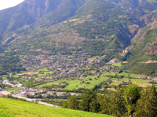

Quart, Aosta Valley
- Italian comune
Hiking in Quart, Aosta Valley
Quart is a charming municipality in the Aosta Valley region of Italy, nestled in the foothills of the Alps. It offers a variety of hiking opportunities that cater to different skill levels and preferences. Here’s an overview of what you can expect when hiking in Quart:...
- Country:
- Postal Code: 11020
- Local Dialing Code: 0165
- Licence Plate Code: AO
- Coordinates: 45° 44' 0" N, 7° 25' 0" E
- GPS tracks (wikiloc): [Link]
- AboveSeaLevel: 535 м m
- Area: 62.05 sq km
- Population: 4066
- Web site: [Link]


Saint-Christophe, Aosta Valley
- Italian comune
Hiking in Saint-Christophe, Aosta Valley
Saint-Christophe, located in the Aosta Valley region of northern Italy, is a wonderful destination for hiking enthusiasts. This charming village is surrounded by stunning alpine scenery and offers a variety of trails suitable for different skill levels. Here’s what you can expect when hiking in and around Saint-Christophe:...
- Country:
- Postal Code: 11020
- Local Dialing Code: 0165
- Licence Plate Code: AO
- Coordinates: 45° 45' 0" N, 7° 21' 0" E
- GPS tracks (wikiloc): [Link]
- AboveSeaLevel: 619 м m
- Area: 14.74 sq km
- Population: 3467
- Web site: [Link]