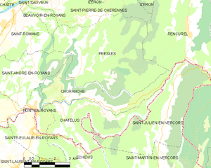
Pont-en-Royans (Pont-en-Royans)

- commune in Isère, France
 Hiking in Pont-en-Royans
Pont-en-Royans is a charming village located in the Isère department of the Auvergne-Rhône-Alpes region in southeastern France. It is known for its picturesque landscape and stunning cliffs that overlook the river Bourne, making it a fantastic destination for hiking enthusiasts.
Hiking Opportunities:
-
Scenic Trails: The area around Pont-en-Royans offers a variety of hiking trails, ranging from easy walks to more challenging hikes. The trails often provide breathtaking views of the Vercors Massif, with its dramatic gorges and unique rock formations.
-
The Gorges de la Bourne: This is one of the most popular hiking destinations near Pont-en-Royans. The path along the river offers refreshing views and is accessible for most hikers. Be sure to watch out for the natural beauty and the various species of flora and fauna along the way.
-
Higher Vercors: For those seeking more challenging hikes, the trails in the Vercors National Park are easily accessible from the village. These trails often lead to higher altitudes, where hikers can enjoy panoramic views of the mountains.
-
Local Flora and Fauna: The region is rich in biodiversity, and while hiking, you might encounter various wildlife species, including chamois and marmots. The diverse habitats also support numerous plant species, particularly wildflowers in the spring.
Practical Tips:
-
Seasonal Considerations: The best time to hike in this area is typically from late spring to early fall when the weather is milder and the trails are clearer.
-
Trail Maps: It’s wise to have a current trail map or GPS device, as some paths may not be well marked.
-
Hydration and Supplies: Make sure to carry sufficient water and snacks, especially on longer hikes, as amenities may be limited on the trails.
-
Safety First: As with any hiking adventure, ensure you’re prepared for the conditions and have appropriate gear, including sturdy footwear and weather-appropriate clothing.
Pont-en-Royans provides an excellent base for exploring the surrounding natural beauty, making it a rewarding experience for hikers of all levels. Whether you’re looking for a leisurely walk or a more strenuous hike, the area has something to offer everyone!
- Country:

- Postal Code: 38680
- Coordinates: 45° 3' 47" N, 5° 20' 34" E


- GPS tracks (wikiloc): [Link]
- Area: 2.9 sq km
- Population: 785
- Web site: http://pont-en-royans.sud-gresivaudan.org
- Wikipedia en: wiki(en)
- Wikipedia: wiki(fr)
- Wikidata storage: Wikidata: Q631960
- Wikipedia Commons Category: [Link]
- Freebase ID: [/m/03g_60k]
- GeoNames ID: Alt: [2986200]
- SIREN number: [213803190]
- BnF ID: [15258131q]
- VIAF ID: Alt: [132200382]
- PACTOLS thesaurus ID: [pcrts3TvicEyGA]
- WOEID: [12668373]
- SUDOC authorities ID: [02948331X]
- INSEE municipality code: 38319
Shares border with regions:


Auberives-en-Royans
- commune in Isère, France
Hiking in Auberives-en-Royans
Auberives-en-Royans is a charming village located in the Isère department in the Auvergne-Rhône-Alpes region of southeastern France. The area is known for its picturesque landscapes, rich history, and outdoor activities, making it a great spot for hiking enthusiasts....
- Country:
- Postal Code: 38680
- Coordinates: 45° 3' 48" N, 5° 18' 5" E
- GPS tracks (wikiloc): [Link]
- Area: 5.07 sq km
- Population: 370


Saint-André-en-Royans
- commune in Isère, France
Hiking in Saint-André-en-Royans
Saint-André-en-Royans is a picturesque village located in the Drôme department of southeastern France, within the stunning Vercors Regional Natural Park. The area is known for its spectacular landscapes, rugged cliffs, lush forests, and unique geological formations, making it a great location for hiking enthusiasts of all levels....
- Country:
- Postal Code: 38680
- Coordinates: 45° 5' 9" N, 5° 20' 19" E
- GPS tracks (wikiloc): [Link]
- Area: 10.42 sq km
- Population: 319
- Web site: [Link]


Sainte-Eulalie-en-Royans
- commune in Drôme, France
Hiking in Sainte-Eulalie-en-Royans
Sainte-Eulalie-en-Royans is a beautiful village located in the Vercors Regional Natural Park in the Auvergne-Rhône-Alpes region of France. It's an excellent starting point for hikers seeking a blend of stunning natural landscapes, diverse trails, and local culture....
- Country:
- Postal Code: 26190
- Coordinates: 45° 2' 51" N, 5° 20' 29" E
- GPS tracks (wikiloc): [Link]
- AboveSeaLevel: 286 м m
- Area: 6.14 sq km
- Population: 548

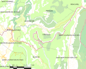
Choranche
- commune in Isère, France
Hiking in Choranche
Choranche, located in the Isère department in the Auvergne-Rhône-Alpes region of France, is known for its stunning natural beauty and outdoor activities, including hiking. The area is particularly famous for its impressive gorges, limestone cliffs, and beautiful landscapes....
- Country:
- Postal Code: 38680
- Coordinates: 45° 4' 1" N, 5° 23' 28" E
- GPS tracks (wikiloc): [Link]
- Area: 10.63 sq km
- Population: 124

Châtelus
- commune in Isère, France
Hiking in Châtelus
Châtelus is a charming village located in the Isère department of the Auvergne-Rhône-Alpes region in southeastern France. The area is known for its picturesque landscapes, making it a great destination for hiking enthusiasts looking to explore natural beauty and enjoy outdoor activities....
- Country:
- Postal Code: 38680
- Coordinates: 45° 3' 29" N, 5° 22' 21" E
- GPS tracks (wikiloc): [Link]
- Area: 12.3 sq km
- Population: 96