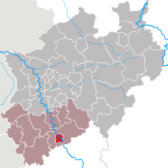
Rhein-Sieg District (Rhein-Sieg-Kreis)


- German district of North Rhine-Westphalia
 Hiking in Rhein-Sieg District
Rhein-Sieg-Kreis, located in North Rhine-Westphalia, Germany, offers a variety of hiking opportunities for both beginners and experienced hikers. This diverse region features beautiful landscapes, rolling hills, forests, rivers, and charming towns, making it an excellent destination for outdoor enthusiasts. Here are some highlights and tips for hiking in this area:
Trails and Routes
-
Westerwald Trails: The Westerwald region, which partially falls within Rhein-Sieg-Kreis, offers numerous well-marked trails. The Westerwaldsteig, a long-distance trail, provides stunning views and traverses through varied terrains, including forests and meadows.
-
Bergisches Land: This hilly area to the north of Rhein-Sieg-Kreis is known for its scenic views. Trails such as the Bergischer Weg offer a mix of forest paths and open fields, ideal for those who appreciate nature.
-
Siegtal: The Siegtal (Siege Valley) offers picturesque routes along the banks of the River Sieg. The Sieg River Trail is particularly beautiful, with options for both leisurely strolls and more challenging hikes.
-
Local Parks: There are several regional parks, such as the Naturpark Siebengebirge, which offers various trails with historical sites and fabulous vistas, including views of the Rhine River.
Difficulty Levels
The trails in Rhein-Sieg-Kreis vary in difficulty from easy walks suitable for families to more challenging routes for experienced hikers. Pay attention to the trail markers and signs, as they will help guide you to the right paths.
Recommendations
-
Best Time to Hike: Spring and autumn are excellent seasons for hiking in this region, as the weather is generally mild and the scenery is particularly beautiful with blooming flowers or colorful foliage.
-
Equipment: Wear sturdy hiking boots, and consider carrying a walking stick for balance on uneven terrain. Always bring enough water, snacks, and a map or GPS device.
-
Local Guidelines: Check local regulations or guidelines before you set out, especially regarding any specific trail rules or natural conservation areas.
-
Public Transport: The region is accessible by public transport, making it easy to reach trailheads.
Safety Tips
- Always inform someone about your hiking plans and estimated return time.
- Check the weather forecast before you head out; conditions can change quickly, especially in the forests.
- Be mindful of wildlife and respect nature.
Whether you're looking for a relaxing day hike or a more challenging adventure, Rhein-Sieg-Kreis offers an impressive array of hiking options that showcase the beauty of the German countryside. Happy hiking!
- Country:

- Licence Plate Code: SU
- Coordinates: 50° 45' 0" N, 7° 15' 0" E


- GPS tracks (wikiloc): [Link]
- AboveSeaLevel: 170 м m
- Area: 1153.2 sq km
- Web site: http://www.rhein-sieg-kreis.de/
- Wikipedia en: wiki(en)
- Wikipedia: wiki(de)
- Wikidata storage: Wikidata: Q6287
- Wikipedia Commons Gallery: [Link]
- Wikipedia Commons Category: [Link]
- Wikipedia Commons Maps Category: [Link]
- Freebase ID: [/m/019d62]
- GeoNames ID: Alt: [2847604]
- VIAF ID: Alt: [125495930]
- OSM relation ID: [62544]
- GND ID: Alt: [4049812-8]
- archINFORM location ID: [2584]
- Library of Congress authority ID: Alt: [n81022493]
- TGN ID: [7112153]
- National Library of Israel ID: [000983715]
- NUTS code: [DEA2C]
- GNS Unique Feature ID: -1849339
- German district key: 05382
Shares border with regions:


Cologne
- city in North Rhine-Westphalia, Germany
Hiking in Cologne
Hiking around Cologne offers a diverse range of outdoor experiences, combining beautiful landscapes, historical sites, and scenic views. While the city itself is urban, there are several excellent hiking options nearby. Here are some highlights:...
- Country:
- Postal Code: 51147; 51145; 51143; 51109; 51107; 51105; 51103; 51069; 51067; 51065; 51063; 51061; 50999; 50997; 50996; 50969; 50968; 50939; 50937; 50935; 50931; 50859; 50858; 50833; 50829; 50827; 50825; 50823; 50739; 50737; 50735; 50733; 50767; 50765; 50679; 50678; 50676; 50677; 50674; 50672; 50670; 50668; 50667; 51149
- Local Dialing Code: 2203; 2236; 2234; 2233; 2232; 221
- Licence Plate Code: K
- Coordinates: 50° 56' 32" N, 6° 57' 28" E
- GPS tracks (wikiloc): [Link]
- AboveSeaLevel: 52 м m
- Area: 405.01 sq km
- Population: 1080394
- Web site: [Link]

Bonn
- city in Germany, former capital
Hiking in Bonn
Bonn, located along the banks of the Rhine River in Germany, is surrounded by beautiful natural landscapes, making it a great place for hiking enthusiasts. The region offers a variety of trails that cater to different skill levels, from leisurely walks along the river to more challenging hikes in the nearby hills and forests. Here are some highlights of hiking in and around Bonn:...
- Country:
- Postal Code: 53111–53229
- Local Dialing Code: 0228
- Licence Plate Code: BN
- Coordinates: 50° 44' 2" N, 7° 5' 59" E
- GPS tracks (wikiloc): [Link]
- AboveSeaLevel: 60 м m
- Area: 141.06 sq km
- Population: 327919
- Web site: [Link]


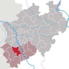
Euskirchen
- German district of North Rhine-Westphalia
Hiking in Euskirchen
Euskirchen district, located in North Rhine-Westphalia, Germany, offers a variety of hiking opportunities that cater to all levels of hikers. The scenic landscapes and diverse terrains make it an attractive destination for outdoor enthusiasts....
- Country:
- Licence Plate Code: EU
- Coordinates: 50° 30' 0" N, 6° 40' 12" E
- GPS tracks (wikiloc): [Link]
- AboveSeaLevel: 418 м m
- Area: 1248.73 sq km
- Web site: [Link]

Rhein-Erft District
- district in North Rhine-Westphalia, Germany
Hiking in Rhein-Erft District
Rhein-Erft-Kreis is a beautiful region in North Rhine-Westphalia, Germany, known for its diverse landscapes, historical sites, and numerous hiking trails. Here’s what you should know about hiking in this area:...
- Country:
- Licence Plate Code: BM
- Coordinates: 50° 55' 12" N, 6° 40' 12" E
- GPS tracks (wikiloc): [Link]
- AboveSeaLevel: 79 м m
- Area: 704.7 sq km
- Web site: [Link]

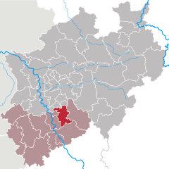
Rhein-Berg District
- district in North Rhine-Westphalia, Germany
Hiking in Rhein-Berg District
The Rheinisch-Bergischer Kreis is a beautiful region located in North Rhine-Westphalia, Germany, known for its diverse landscapes, picturesque villages, and extensive network of hiking trails. Here are some key highlights and tips regarding hiking in this area:...
- Country:
- Licence Plate Code: GL
- Coordinates: 51° 1' 0" N, 7° 12' 0" E
- GPS tracks (wikiloc): [Link]
- AboveSeaLevel: 235 м m
- Area: 438 sq km
- Web site: [Link]

Oberbergischer Kreis
- district of North Rhine-Westphalia, Germany
Hiking in Oberbergischer Kreis
Oberbergischer Kreis, located in North Rhine-Westphalia, Germany, is known for its beautiful landscapes, rolling hills, and dense forests, making it a fantastic destination for hiking enthusiasts. Here are some key details to help you plan your hiking adventure in this region:...
- Country:
- Licence Plate Code: GM
- Coordinates: 51° 2' 0" N, 7° 31' 0" E
- GPS tracks (wikiloc): [Link]
- AboveSeaLevel: 413 м m
- Area: 918.53 sq km
- Population: 271332
- Web site: [Link]