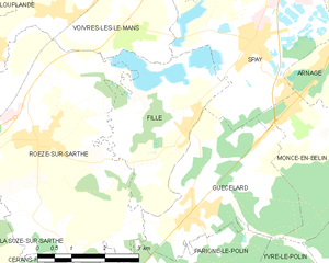
Roézé-sur-Sarthe (Roézé-sur-Sarthe)

- commune in Sarthe, France
- Country:

- Postal Code: 72210
- Coordinates: 47° 53' 45" N, 0° 4' 1" E


- GPS tracks (wikiloc): [Link]
- Area: 26.46 sq km
- Population: 2631
- Wikipedia en: wiki(en)
- Wikipedia: wiki(fr)
- Wikidata storage: Wikidata: Q1227633
- Wikipedia Commons Category: [Link]
- Freebase ID: [/m/03qj0dm]
- GeoNames ID: Alt: [6442670]
- SIREN number: [217202530]
- BnF ID: [152738070]
- INSEE municipality code: 72253
Shares border with regions:


Cérans-Foulletourte
- commune in Sarthe, France
- Country:
- Postal Code: 72330
- Coordinates: 47° 49' 38" N, 0° 4' 35" E
- GPS tracks (wikiloc): [Link]
- AboveSeaLevel: 64 м m
- Area: 32.52 sq km
- Population: 3384
- Web site: [Link]


Voivres-lès-le-Mans
- commune in Sarthe, France
- Country:
- Postal Code: 72210
- Coordinates: 47° 55' 47" N, 0° 4' 20" E
- GPS tracks (wikiloc): [Link]
- Area: 11.44 sq km
- Population: 1379


Chemiré-le-Gaudin
- commune in Sarthe, France
- Country:
- Postal Code: 72210
- Coordinates: 47° 55' 42" N, 0° 0' 54" E
- GPS tracks (wikiloc): [Link]
- Area: 22.79 sq km
- Population: 958

Fillé
- commune in Sarthe, France
- Country:
- Postal Code: 72210
- Coordinates: 47° 53' 55" N, 0° 7' 28" E
- GPS tracks (wikiloc): [Link]
- Area: 10.07 sq km
- Population: 1518
- Web site: [Link]


La Suze-sur-Sarthe
- commune in Sarthe, France
- Country:
- Postal Code: 72210
- Coordinates: 47° 53' 23" N, 0° 1' 31" E
- GPS tracks (wikiloc): [Link]
- AboveSeaLevel: 76 м m
- Area: 21.4 sq km
- Population: 4460
- Web site: [Link]


Guécélard
- commune in Sarthe, France
- Country:
- Postal Code: 72230
- Coordinates: 47° 52' 33" N, 0° 7' 46" E
- GPS tracks (wikiloc): [Link]
- Area: 12.18 sq km
- Population: 2976
- Web site: [Link]


Parigné-le-Pôlin
- commune in Sarthe, France
- Country:
- Postal Code: 72330
- Coordinates: 47° 51' 2" N, 0° 6' 29" E
- GPS tracks (wikiloc): [Link]
- Area: 13.85 sq km
- Population: 1093
- Web site: [Link]


Louplande
- commune in Sarthe, France
- Country:
- Postal Code: 72210
- Coordinates: 47° 56' 36" N, 0° 2' 30" E
- GPS tracks (wikiloc): [Link]
- Area: 18.47 sq km
- Population: 1472
- Web site: [Link]