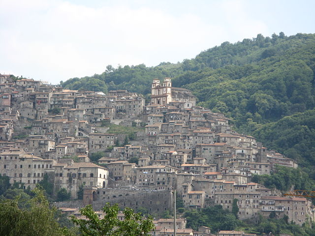
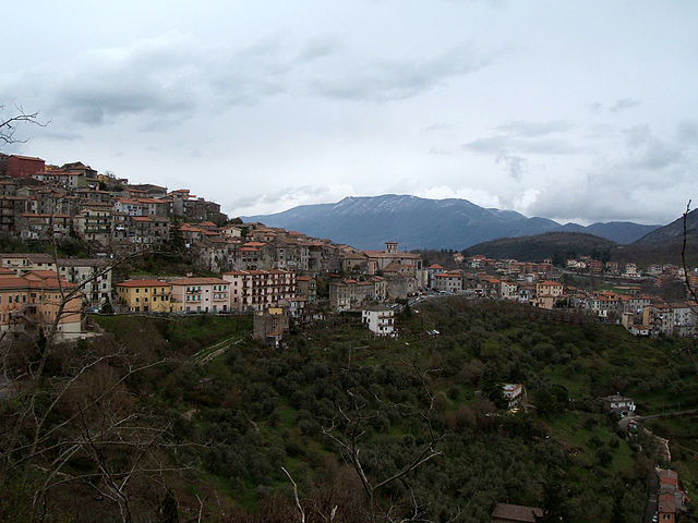
Rocca Massima (Rocca Massima)
.svg)
- Italian comune
 Hiking in Rocca Massima
Rocca Massima is a small town located in the province of Latina, in the Lazio region of Italy. Nestled in the charming landscapes of the Lepini Mountains, it offers stunning views and a variety of hiking opportunities for both beginners and experienced hikers.
Hiking Trails
-
Sentiero del Cacciatore: This is one of the most popular trails in the area. It takes you through beautiful wooded areas and provides a good balance of challenging ascents and flatter sections. The views from the trail are spectacular, especially during the early morning or late afternoon.
-
Monte Semprevisa: For those looking for a more strenuous hike, the ascent to Monte Semprevisa is rewarding. The hike offers panoramic views of the surrounding valleys and mountains. The trail typically takes a few hours, and the summit is a great place to rest and enjoy a packed lunch.
-
The Ancient Villages Trail: This trail takes you through some of the nearby historic villages, showcasing the cultural heritage of the area. It’s a more leisurely hike and perfect for those who enjoy a mix of nature and exploration.
Wildlife and Scenery
The area around Rocca Massima is rich in biodiversity. You'll have the opportunity to see various species of birds and perhaps spot local wildlife like deer or foxes. The lush greenery and diverse flora provide a beautiful backdrop for your hike, especially in spring and early summer when the wildflowers are in bloom.
Climate and Best Time to Visit
The best time to hike in Rocca Massima is during the spring (April to June) and early autumn (September to October) when the weather is pleasantly mild, and the landscapes are particularly vibrant. Summers can be hot, so it’s important to hike early in the day or later in the evening to avoid the midday heat.
Tips for Hiking in Rocca Massima
- Hydration: Always carry enough water, especially during warmer months.
- Footwear: Wear sturdy hiking shoes with good grip, as some trails can be rocky and steep.
- Trail Maps: While many trails are well marked, it's a good idea to carry a map or GPS device for navigation.
- Local Regulations: Be aware of local rules regarding wildlife protection and trail use, especially when passing through natural reserves.
Conclusion
Hiking in Rocca Massima is an excellent choice for anyone looking to enjoy nature while exploring the scenic beauty and rich culture of this part of Italy. Whether you seek challenging hikes or gentle walks, Rocca Massima has something to offer every outdoor enthusiast.
- Country:

- Postal Code: 04010
- Local Dialing Code: 06
- Licence Plate Code: LT
- Coordinates: 41° 41' 0" N, 12° 55' 0" E


- GPS tracks (wikiloc): [Link]
- AboveSeaLevel: 735 м m
- Area: 18.17 sq km
- Population: 1135
- Web site: http://www.comuneroccamassima.it/
- Wikipedia en: wiki(en)
- Wikipedia: wiki(it)
- Wikidata storage: Wikidata: Q128157
- Wikipedia Commons Category: [Link]
- Freebase ID: [/m/0gm8z7]
- GeoNames ID: Alt: [6538698]
- OSM relation ID: [41489]
- ISTAT ID: 059022
- Italian cadastre code: H421
Shares border with regions:


Cori
- Italian comune
Hiking in Cori
Cori, located in the region of Lazio, is known for its picturesque landscapes, rich history, and charming medieval architecture. Hiking in this area offers a blend of natural beauty and cultural exploration, making it a rewarding experience....
- Country:
- Postal Code: 04010
- Local Dialing Code: 06
- Licence Plate Code: LT
- Coordinates: 41° 39' 0" N, 12° 55' 0" E
- GPS tracks (wikiloc): [Link]
- AboveSeaLevel: 384 м m
- Area: 85.31 sq km
- Population: 10893
- Web site: [Link]

Artena
- Italian comune
Hiking in Artena
Artena is a charming hilltop town located in the province of Rome, Italy. It is set in the beautiful landscape of the Lazio region, surrounded by hills, forests, and panoramic views, making it a great destination for hiking enthusiasts. Here are a few highlights about hiking in and around Artena:...
- Country:
- Postal Code: 00031
- Local Dialing Code: 06
- Licence Plate Code: RM
- Coordinates: 41° 44' 0" N, 12° 55' 0" E
- GPS tracks (wikiloc): [Link]
- AboveSeaLevel: 420 м m
- Area: 54.8 sq km
- Population: 14107
- Web site: [Link]


Colleferro
- Italian comune
Hiking in Colleferro
Colleferro, located in the Lazio region of Italy, offers a variety of hiking opportunities thanks to its picturesque landscapes and proximity to the beautiful Monti Lepini mountain range. Here’s a breakdown of what you can expect when hiking in and around Colleferro:...
- Country:
- Postal Code: 00034
- Local Dialing Code: 06
- Licence Plate Code: ROMA
- Coordinates: 41° 43' 43" N, 13° 0' 11" E
- GPS tracks (wikiloc): [Link]
- AboveSeaLevel: 218 м m
- Area: 27 sq km
- Population: 21394
- Web site: [Link]

Segni
- Italian comune
Hiking in Segni
Segni, located in the province of Rome, Italy, offers a range of hiking opportunities with its beautiful landscapes, historical sites, and varied terrain. Nestled in the foothills of the Lepini Mountains, this area is perfect for outdoor enthusiasts looking to explore nature while appreciating the rich cultural heritage of the region....
- Country:
- Postal Code: 00037
- Local Dialing Code: 06
- Licence Plate Code: RM
- Coordinates: 41° 41' 0" N, 13° 1' 0" E
- GPS tracks (wikiloc): [Link]
- AboveSeaLevel: 668 м m
- Area: 60.86 sq km
- Population: 9192
- Web site: [Link]