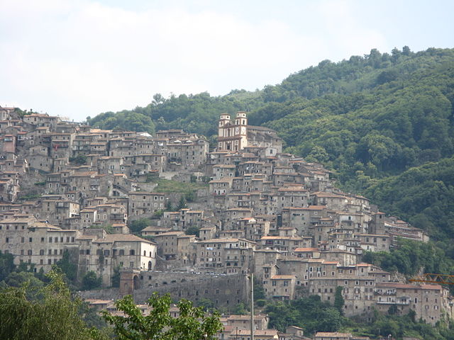
Segni (Segni)
.svg)
- Italian comune
 Hiking in Segni
Segni, located in the province of Rome, Italy, offers a range of hiking opportunities with its beautiful landscapes, historical sites, and varied terrain. Nestled in the foothills of the Lepini Mountains, this area is perfect for outdoor enthusiasts looking to explore nature while appreciating the rich cultural heritage of the region.
Hiking Opportunities:
-
Trails and Nature Parks:
- Segni is surrounded by various trails that wind through woodlands, hills, and valleys. The nearby Monti Lepini Regional Park offers well-marked hiking paths suitable for different skill levels, from beginners to more experienced hikers.
- The trails often lead to scenic viewpoints where hikers can enjoy panoramic views of the surrounding countryside.
-
Historical Sites:
- As you hike, you may encounter remnants of ancient Roman ruins and other historical landmarks that offer a glimpse into the past. These sites add a cultural dimension to your outdoor experience.
-
The Environment:
- The rich biodiversity in this area makes it ideal for nature lovers. You may spot various wildlife species, including birds and small mammals.
- The lush vegetation and changing scenery throughout the year provide a stunning backdrop for hiking.
Tips for Hiking in Segni:
- Preparation: Always check the weather forecast before heading out, and dress appropriately for the conditions. Good hiking boots are essential to tackle uneven terrain.
- Hydration and Snacks: Carry enough water and snacks to keep your energy up during longer hikes.
- Navigation: Familiarize yourself with trail maps or use a hiking app to stay on course. Some trails may not be well marked.
- Respect Nature: Follow the Leave No Trace principles, and be respectful of wildlife and the environment.
Best Times to Hike:
- Spring and Fall: These seasons are particularly lovely for hiking in Segni due to mild temperatures and vibrant foliage. Spring brings blooming wildflowers, while fall showcases the stunning autumn colors.
- Summer: While summer can be hot, early morning or late afternoon hikes can offer beautiful scenery and cooler temperatures.
In summary, hiking in Segni provides a wonderful blend of nature and history, making it a rewarding experience for all levels of hikers. Whether you're looking for a leisurely walk or a more challenging trek, there are ample opportunities to explore the beautiful landscape and enjoy the tranquility of this picturesque Italian region.
- Country:

- Postal Code: 00037
- Local Dialing Code: 06
- Licence Plate Code: RM
- Coordinates: 41° 41' 0" N, 13° 1' 0" E


- GPS tracks (wikiloc): [Link]
- AboveSeaLevel: 668 м m
- Area: 60.86 sq km
- Population: 9192
- Web site: http://www.comune.segni.rm.it
- Wikipedia en: wiki(en)
- Wikipedia: wiki(it)
- Wikidata storage: Wikidata: Q243458
- Wikipedia Commons Category: [Link]
- Freebase ID: [/m/031t5y]
- GeoNames ID: Alt: [6539979]
- BnF ID: [15066422z]
- VIAF ID: Alt: [148196365]
- OSM relation ID: [41473]
- GND ID: Alt: [4440235-1]
- Library of Congress authority ID: Alt: [nr94014091]
- Digital Atlas of the Roman Empire ID: [21312]
- Pleiades ID: [423072]
- Catholic Encyclopedia ID: [13683b]
- ISTAT ID: 058102
- Italian cadastre code: I573
Shares border with regions:


Anagni
- Italian comune
Hiking in Anagni
Anagni, located in the province of Frosinone in Italy, is a historic town with a rich cultural heritage and beautiful natural landscapes, making it an excellent destination for hiking enthusiasts. Here are some highlights and tips for hiking in the Anagni area:...
- Country:
- Postal Code: 03012
- Local Dialing Code: 0775
- Licence Plate Code: FR
- Coordinates: 41° 45' 0" N, 13° 9' 0" E
- GPS tracks (wikiloc): [Link]
- AboveSeaLevel: 475 м m
- Area: 112.82 sq km
- Population: 21404
- Web site: [Link]
Paliano
- Italian comune
Hiking in Paliano
Paliano, located in the province of Frosinone in the Lazio region of Italy, is an area known for its picturesque landscapes and historical significance. Hiking in Paliano can provide an excellent opportunity to explore both natural beauty and cultural sites....
- Country:
- Postal Code: 03018
- Local Dialing Code: 0775
- Licence Plate Code: FR
- Coordinates: 41° 48' 0" N, 13° 3' 0" E
- GPS tracks (wikiloc): [Link]
- AboveSeaLevel: 471 м m
- Area: 70.64 sq km
- Population: 8163
- Web site: [Link]


Cori
- Italian comune
Hiking in Cori
Cori, located in the region of Lazio, is known for its picturesque landscapes, rich history, and charming medieval architecture. Hiking in this area offers a blend of natural beauty and cultural exploration, making it a rewarding experience....
- Country:
- Postal Code: 04010
- Local Dialing Code: 06
- Licence Plate Code: LT
- Coordinates: 41° 39' 0" N, 12° 55' 0" E
- GPS tracks (wikiloc): [Link]
- AboveSeaLevel: 384 м m
- Area: 85.31 sq km
- Population: 10893
- Web site: [Link]
Rocca Massima
- Italian comune
Hiking in Rocca Massima
Rocca Massima is a small town located in the province of Latina, in the Lazio region of Italy. Nestled in the charming landscapes of the Lepini Mountains, it offers stunning views and a variety of hiking opportunities for both beginners and experienced hikers....
- Country:
- Postal Code: 04010
- Local Dialing Code: 06
- Licence Plate Code: LT
- Coordinates: 41° 41' 0" N, 12° 55' 0" E
- GPS tracks (wikiloc): [Link]
- AboveSeaLevel: 735 м m
- Area: 18.17 sq km
- Population: 1135
- Web site: [Link]

Artena
- Italian comune
Hiking in Artena
Artena is a charming hilltop town located in the province of Rome, Italy. It is set in the beautiful landscape of the Lazio region, surrounded by hills, forests, and panoramic views, making it a great destination for hiking enthusiasts. Here are a few highlights about hiking in and around Artena:...
- Country:
- Postal Code: 00031
- Local Dialing Code: 06
- Licence Plate Code: RM
- Coordinates: 41° 44' 0" N, 12° 55' 0" E
- GPS tracks (wikiloc): [Link]
- AboveSeaLevel: 420 м m
- Area: 54.8 sq km
- Population: 14107
- Web site: [Link]


Colleferro
- Italian comune
Hiking in Colleferro
Colleferro, located in the Lazio region of Italy, offers a variety of hiking opportunities thanks to its picturesque landscapes and proximity to the beautiful Monti Lepini mountain range. Here’s a breakdown of what you can expect when hiking in and around Colleferro:...
- Country:
- Postal Code: 00034
- Local Dialing Code: 06
- Licence Plate Code: ROMA
- Coordinates: 41° 43' 43" N, 13° 0' 11" E
- GPS tracks (wikiloc): [Link]
- AboveSeaLevel: 218 м m
- Area: 27 sq km
- Population: 21394
- Web site: [Link]


Gavignano
- Italian comune
Hiking in Gavignano
Gavignano, a charming village in the province of Rome, Italy, offers some beautiful hiking opportunities thanks to its picturesque landscapes and proximity to the Monti Simbruini National Park. Here are some highlights for hiking in and around Gavignano:...
- Country:
- Postal Code: 00030
- Local Dialing Code: 06
- Licence Plate Code: RM
- Coordinates: 41° 42' 0" N, 13° 3' 0" E
- GPS tracks (wikiloc): [Link]
- AboveSeaLevel: 404 м m
- Area: 15.04 sq km
- Population: 1905
- Web site: [Link]
Montelanico
- Italian comune
Hiking in Montelanico
Montelanico is a charming town located in the Lazio region of central Italy, known for its beautiful landscapes and proximity to the Apennine mountains. Hiking in and around Montelanico offers a unique opportunity to explore stunning natural scenery, charming villages, and a rich array of local flora and fauna. Here are some key points to consider when hiking in this area:...
- Country:
- Postal Code: 00030
- Local Dialing Code: 06
- Licence Plate Code: ROMA
- Coordinates: 41° 39' 0" N, 13° 2' 23" E
- GPS tracks (wikiloc): [Link]
- AboveSeaLevel: 297 м m
- Area: 35.14 sq km
- Population: 2125
- Web site: [Link]