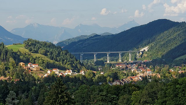
Saint-Paul-lès-Monestier (Saint-Paul-lès-Monestier)
- commune in Isère, France
 Hiking in Saint-Paul-lès-Monestier
Saint-Paul-lès-Monestier is a picturesque village located in the Isère department in the Auvergne-Rhône-Alpes region of southeastern France. It serves as an excellent base for hiking enthusiasts who want to explore the beautiful landscapes of the Vercors Massif.
Hiking Trails
-
Vercors Regional Natural Park: Saint-Paul-lès-Monestier is close to the Vercors Regional Natural Park, known for its dramatic cliffs, vast plateaus, and diverse ecosystems. There are numerous trails ranging from easy walks to more challenging hikes.
-
La Traversée des Vercors: This long-distance trail runs through the Vercors Massif, passing through stunning landscapes, forests, and charming villages. Portions of this trail can be accessed from Saint-Paul-lès-Monestier.
-
Local Trails: The area surrounding Saint-Paul-lès-Monestier offers many shorter trails perfect for day hikes. You can explore the forests, alpine meadows, and enjoy views of the surrounding mountains. Check local maps and guides for specific trails and their difficulty levels.
Highlights
- Scenic Views: Hikers can enjoy breathtaking views of the Vercors mountains and the surrounding valleys.
- Wildlife: The region is home to diverse wildlife, including deer, chamois, and numerous bird species.
- Cultural Heritage: Some trails may lead you to historical sites or traditional alpine farms, providing insight into local culture and history.
Tips for Hiking in Saint-Paul-lès-Monestier
- Weather Awareness: Be mindful of the weather, especially as conditions can change rapidly in mountainous areas.
- Trail Maps: Carry a detailed map or use a hiking app to ensure you stay on track. Local tourism offices can provide valuable information.
- Safety Gear: Wear appropriate hiking gear, including sturdy boots, and carry sufficient water and snacks.
- Leave No Trace: Respect nature by following the Leave No Trace principles, ensuring that the environment remains pristine for future hikers.
Whether you're a beginner or an experienced hiker, Saint-Paul-lès-Monestier offers beautiful trails and stunning natural landscapes that make for an enjoyable hiking experience.
- Country:

- Postal Code: 38650
- Coordinates: 44° 55' 46" N, 5° 37' 40" E


- GPS tracks (wikiloc): [Link]
- Area: 13.88 sq km
- Population: 257
- Wikipedia en: wiki(en)
- Wikipedia: wiki(fr)
- Wikidata storage: Wikidata: Q1150631
- Wikipedia Commons Category: [Link]
- Freebase ID: [/m/03g_5cy]
- GeoNames ID: Alt: [6433383]
- SIREN number: [213804388]
- BnF ID: [15258247c]
- INSEE municipality code: 38438
Shares border with regions:


Monestier-de-Clermont
- commune in Isère, France
 Hiking in Monestier-de-Clermont
Monestier-de-Clermont, located in the picturesque Isère department in the Auvergne-Rhône-Alpes region of France, offers a variety of hiking opportunities that showcase the stunning natural beauty of the French Alps. Here are some highlights and tips for hiking in this area:...
- Country:

- Postal Code: 38650
- Coordinates: 44° 55' 1" N, 5° 38' 7" E


- GPS tracks (wikiloc): [Link]
- Area: 5.45 sq km
- Population: 1426
- Web site: [Link]


Saint-Guillaume
- commune in Isère, France
Saint-Guillaume, located in Quebec, Canada, offers a variety of hiking opportunities amidst beautiful natural landscapes. The area is characterized by its lush forests, rolling hills, and scenic views, making it an appealing destination for both novice and experienced hikers....
- Country:

- Postal Code: 38650
- Coordinates: 44° 57' 18" N, 5° 35' 21" E


- GPS tracks (wikiloc): [Link]
- Area: 13.33 sq km
- Population: 265


Miribel-Lanchâtre
- commune in Isère, France
Miribel-Lanchâtre is a charming destination in the department of Isère, in the Auvergne-Rhône-Alpes region of France. It offers beautiful landscapes, rich biodiversity, and various hiking opportunities that cater to different skill levels, making it an excellent spot for hiking enthusiasts....
- Country:

- Postal Code: 38450
- Coordinates: 44° 58' 28" N, 5° 37' 13" E


- GPS tracks (wikiloc): [Link]
- Area: 9.65 sq km
- Population: 415
- Web site: [Link]


Gresse-en-Vercors
- commune in Isère, France
Gresse-en-Vercors is a charming village located in the Vercors Regional Natural Park in the French Alps. It’s an exceptional area for hiking, offering a variety of trails that cater to a range of skill levels, from beginners to experienced hikers. Here are some highlights and things to consider when hiking in Gresse-en-Vercors:...
- Country:

- Postal Code: 38650
- Coordinates: 44° 54' 8" N, 5° 34' 0" E


- GPS tracks (wikiloc): [Link]
- Area: 81.13 sq km
- Population: 395
- Web site: [Link]


Roissard
- commune in Isère, France
Roissard is a charming village located in the French Alps, specifically in the Isère department, offering stunning natural beauty and a variety of hiking opportunities for outdoor enthusiasts. Here are some key points to consider if you’re looking to hike in and around Roissard:...
- Country:

- Postal Code: 38650
- Coordinates: 44° 52' 56" N, 5° 38' 23" E


- GPS tracks (wikiloc): [Link]
- Area: 14.25 sq km
- Population: 298
- Web site: [Link]


Sinard
- commune in Isère, France
Sinard is a beautiful area that offers various hiking opportunities, though it’s less widely known compared to some other hiking destinations. The region is characterized by stunning landscapes, including mountains, forests, and possibly bodies of water, making it an excellent choice for nature enthusiasts....
- Country:

- Postal Code: 38650
- Coordinates: 44° 56' 44" N, 5° 39' 25" E


- GPS tracks (wikiloc): [Link]
- Area: 10.44 sq km
- Population: 662
