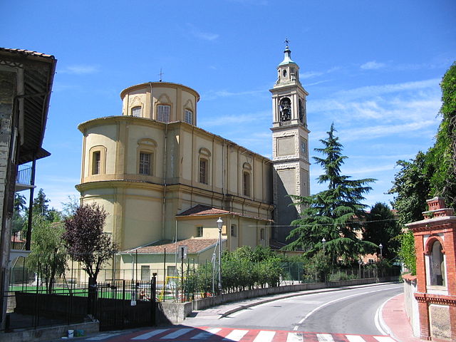
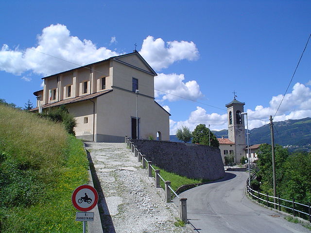
Roncola (Roncola)
.svg)
- Italian comune
 Hiking in Roncola
Roncola is a picturesque area in Italy, situated in the Lombardy region, near the beautiful Bergamo Alps. It's known for its stunning landscapes, rich history, and various hiking opportunities. Here are some key points to consider if you're planning a hiking trip in and around Roncola:
Hiking Trails
-
Sentiero dei Lupi: This is one of the popular hiking paths in the area. It offers breathtaking views of the surrounding mountains and valleys. The trail is suitable for various skill levels, making it accessible for families and casual hikers.
-
Monte Stizzo: A hike to Monte Stizzo provides a rewarding experience with panoramic views of the surrounding areas, including Bergamo and the nearby lakes. The trail can be steep in sections, so a reasonable level of fitness is recommended.
-
Paths through the Woods: There are several lesser-known paths that lead through the regional forests, featuring diverse flora and fauna. These trails can be an excellent way to connect with nature and enjoy a tranquil hiking experience.
Best Time to Hike
- Spring (March to June): This is a wonderful time for hiking, as the weather is generally mild, and wildflowers begin to bloom. The area becomes vibrant during this season.
- Fall (September to November): Autumn offers beautiful foliage and a cooler climate, making it perfect for hiking, although you should be prepared for occasional rain.
Tips for Hiking in Roncola
- Proper Gear: Wear sturdy hiking boots and weather-appropriate clothing. Waterproof gear is advisable if you're hiking during the rainy season.
- Stay Hydrated: Carry enough water, especially on longer hikes, as some trails may not have reliable water sources.
- Navigation: Familiarize yourself with maps or use hiking apps to ensure you stay on track. Marked trails can help, but it's always good to have a backup.
- Local Wildlife: Be respectful of nature and wildlife. Make noise to avoid surprising animals and dispose of waste properly.
Additional Attractions
- Local Cuisine: After a hike, treat yourself to local specialties in nearby villages. Lombardy is known for its delicious cheeses, salamis, and hearty pasta dishes.
- Cultural Sites: Explore historical landmarks and churches in the area, which can provide insight into the local culture and history.
Always check local guidelines and trail conditions before heading out, as some trails may have seasonal restrictions or maintenance work. Enjoy your hiking adventure in Roncola!
- Country:

- Postal Code: 24030
- Local Dialing Code: 035
- Licence Plate Code: BG
- Coordinates: 45° 46' 0" N, 9° 33' 0" E


- GPS tracks (wikiloc): [Link]
- AboveSeaLevel: 854 м m
- Area: 5.07 sq km
- Population: 780
- Web site: http://www.comune.roncola.bg.it/
- Wikipedia en: wiki(en)
- Wikipedia: wiki(it)
- Wikidata storage: Wikidata: Q101519
- Wikipedia Commons Gallery: [Link]
- Wikipedia Commons Category: [Link]
- Freebase ID: [/m/0gjdfq]
- GeoNames ID: Alt: [6543166]
- VIAF ID: Alt: [149128087]
- OSM relation ID: [46074]
- ISTAT ID: 016185
- Italian cadastre code: H544
Shares border with regions:


Capizzone
- Italian comune
Hiking in Capizzone
Capizzone is a charming town located in the Lombardy region of Italy, nestled in the foothills of the Alps. It is a great area for hiking enthusiasts, offering a variety of trails that showcase the stunning landscapes, lush greenery, and breathtaking views of the surrounding mountains and valleys....
- Country:
- Postal Code: 24030
- Local Dialing Code: 035
- Licence Plate Code: BG
- Coordinates: 45° 47' 8" N, 9° 34' 0" E
- GPS tracks (wikiloc): [Link]
- AboveSeaLevel: 454 м m
- Area: 4.68 sq km
- Population: 1231
- Web site: [Link]

Caprino Bergamasco
- Italian comune
Hiking in Caprino Bergamasco
Caprino Bergamasco, located in the Lombardy region of Italy, offers a variety of hiking opportunities amidst beautiful landscapes. The area is characterized by rolling hills, picturesque villages, and stunning views of the surrounding valleys and mountains....
- Country:
- Postal Code: 24030
- Local Dialing Code: 035
- Licence Plate Code: BG
- Coordinates: 45° 45' 25" N, 9° 29' 4" E
- GPS tracks (wikiloc): [Link]
- AboveSeaLevel: 315 м m
- Area: 8.78 sq km
- Population: 3067
- Web site: [Link]


Costa Valle Imagna
- Italian comune
Hiking in Costa Valle Imagna
Costa Valle Imagna, located in the Lombardy region of Italy, offers a wonderful hiking experience characterized by picturesque landscapes, charming villages, and a rich cultural heritage. Here are some key points about hiking in this area:...
- Country:
- Postal Code: 24030
- Local Dialing Code: 035
- Licence Plate Code: BG
- Coordinates: 45° 48' 0" N, 9° 30' 0" E
- GPS tracks (wikiloc): [Link]
- AboveSeaLevel: 1014 м m
- Area: 4.21 sq km
- Population: 587
- Web site: [Link]


Palazzago
- Italian comune
Hiking in Palazzago
Palazzago, located in the Lombardy region of Italy, offers a picturesque setting for hiking enthusiasts. Nestled in the foothills of the Bergamasque Alps, this area features a mix of natural beauty, historical sites, and charming villages, making it an attractive destination for outdoor activities....
- Country:
- Postal Code: 24030
- Local Dialing Code: 035
- Licence Plate Code: BG
- Coordinates: 45° 45' 7" N, 9° 32' 7" E
- GPS tracks (wikiloc): [Link]
- AboveSeaLevel: 397 м m
- Area: 13.98 sq km
- Population: 4497
- Web site: [Link]


Sant'Omobono Terme
- Italian comune
Hiking in Sant'Omobono Terme
Sant'Omobono Terme is a charming town located in the province of Bergamo, Lombardy, Italy. It is well-known for its thermal springs and beautiful surrounding landscapes, making it an attractive destination for hikers and outdoor enthusiasts....
- Country:
- Postal Code: 24038
- Local Dialing Code: 035
- Licence Plate Code: BG
- Coordinates: 45° 48' 33" N, 9° 32' 14" E
- GPS tracks (wikiloc): [Link]
- AboveSeaLevel: 427 м m
- Area: 16.43 sq km
- Population: 3940
- Web site: [Link]


Strozza
- Italian comune
Hiking in Strozza
Strozza is a charming village located in the Lombardy region of Italy, nestled in the Bergamasque Alps. It offers a unique blend of cultural experiences and outdoor activities, making it an excellent destination for hiking enthusiasts....
- Country:
- Postal Code: 24030
- Local Dialing Code: 035
- Licence Plate Code: BG
- Coordinates: 45° 46' 0" N, 9° 35' 0" E
- GPS tracks (wikiloc): [Link]
- AboveSeaLevel: 378 м m
- Area: 3.83 sq km
- Population: 1071
- Web site: [Link]
Torre de' Busi
- Italian comune
Hiking in Torre de' Busi
Torre de' Busi is a small town located in the Lombardy region of Italy, nestled in the hills near the scenic area of Bergamo. The surrounding landscape offers numerous opportunities for hiking enthusiasts and nature lovers alike. Here’s a guide to hiking in Torre de' Busi and its surroundings:...
- Country:
- Postal Code: 24032; 23806
- Local Dialing Code: 035
- Licence Plate Code: BG
- Coordinates: 45° 46' 0" N, 9° 29' 0" E
- GPS tracks (wikiloc): [Link]
- AboveSeaLevel: 472 м m
- Area: 8.97 sq km
- Population: 2077
- Web site: [Link]


Almenno San Bartolomeo
- Italian comune
Hiking in Almenno San Bartolomeo
Almenno San Bartolomeo is a picturesque commune located in the Lombardy region of Italy, near Bergamo. The area is known for its beautiful landscapes, charming villages, and a network of hiking trails that cater to various experience levels. Here are some highlights and tips for hiking in Almenno San Bartolomeo:...
- Country:
- Postal Code: 24030
- Local Dialing Code: 035
- Licence Plate Code: BG
- Coordinates: 45° 44' 56" N, 9° 34' 47" E
- GPS tracks (wikiloc): [Link]
- AboveSeaLevel: 352 м m
- Area: 10.61 sq km
- Population: 6247
- Web site: [Link]

Bedulita
- Italian comune
Hiking in Bedulita
Bedulita is a small village located in the province of Bergamo, Lombardy, Italy. It is situated in the foothills of the Alps, making it a great starting point for hiking and exploring the natural beauty of the surrounding area....
- Country:
- Postal Code: 24030
- Local Dialing Code: 035
- Licence Plate Code: BG
- Coordinates: 45° 47' 29" N, 9° 33' 4" E
- GPS tracks (wikiloc): [Link]
- AboveSeaLevel: 600 м m
- Area: 4.27 sq km
- Population: 732
- Web site: [Link]