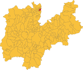
Ronzone (Ronzone)
- Italian comune
Ronzone is a picturesque village located in the Trentino region of northern Italy, known for its stunning landscapes and excellent hiking opportunities. Nestled in the Val di Non, Ronzone offers a range of trails that cater to hikers of all skill levels, from leisurely strolls to challenging alpine routes.
Key Hiking Trails in Ronzone:
-
Sentiero dei Fiori (Flower Trail):
- Difficulty: Easy to Moderate
- Description: This trail takes you through meadows filled with wildflowers and offers beautiful views of the surrounding mountains. It's a great choice for families and those looking for a more relaxed hike.
-
Doss dei Trent'Anni:
- Difficulty: Moderate
- Description: This hike leads you to a viewpoint that offers panoramic vistas of the surrounding valleys and peaks. The trail can be a bit steep in places, but the views at the top are well worth the effort.
-
Val di Non Trails:
- Difficulty: Varies
- Description: The nearby Val di Non offers a network of trails that connect various towns and natural attractions. You can catch trails that lead to waterfalls, lakes, and historical sites, making it ideal for multi-day hikes or leisurely exploration.
Important Tips for Hiking in Ronzone:
- Weather Considerations: Always check the weather before heading out, as conditions can change rapidly in the mountains.
- Footwear and Gear: Wear sturdy hiking boots and bring appropriate gear, including water, snacks, and a first-aid kit.
- Navigation: While the trails are generally well-marked, it's advisable to carry a map or GPS device in case you stray off the beaten path.
- Respect Nature: Stay on marked trails, carry out any trash, and be mindful of local wildlife.
Additional Attractions:
Aside from hiking, Ronzone is known for its apple orchards, charming architecture, and rich cultural heritage. After your hike, you might want to explore local cuisine or visit nearby towns like Fondo and Malè.
Overall, Ronzone is a fantastic destination for hikers seeking both tranquility and natural beauty in the heart of the Italian Alps. Enjoy your hiking adventures!
- Country:

- Postal Code: 38010
- Local Dialing Code: 0463
- Licence Plate Code: TN
- Coordinates: 46° 25' 0" N, 11° 9' 0" E


- GPS tracks (wikiloc): [Link]
- AboveSeaLevel: 1085 м m
- Area: 5.3 sq km
- Population: 436
- Web site: http://www.comune.ronzone.tn.it/
- Wikipedia en: wiki(en)
- Wikipedia: wiki(it)
- Wikidata storage: Wikidata: Q301067
- Wikipedia Commons Category: [Link]
- Freebase ID: [/m/0gb098]
- GeoNames ID: Alt: [6539682]
- OSM relation ID: [47196]
- ISTAT ID: 022159
- Italian cadastre code: H552
Shares border with regions:


Eppan an der Weinstraße
- Italian comune
 Hiking in Eppan an der Weinstraße
Eppan an der Weinstraße, located in the South Tyrol region of northern Italy, is a beautiful destination for hiking enthusiasts. Nestled amidst vineyards and rolling hills, this area offers a variety of trails suitable for all levels of hikers, from easy walks to more challenging treks. Here are some highlights of hiking in Eppan:...
- Country:

- Postal Code: 39050; 39057
- Local Dialing Code: 0471
- Licence Plate Code: BZ
- Coordinates: 46° 27' 0" N, 11° 16' 0" E


- GPS tracks (wikiloc): [Link]
- AboveSeaLevel: 239 м m
- Area: 59.45 sq km
- Population: 14941
- Web site: [Link]

Fondo
- Italian comune
Fondo is a picturesque village located in the heart of the Val di Non region in northern Italy. It’s surrounded by stunning landscapes, including mountains, forests, and charming meadows, making it an excellent destination for hiking enthusiasts. Here's what you should know about hiking in Fondo:...
- Country:

- Postal Code: 38013
- Local Dialing Code: 0463
- Licence Plate Code: TN
- Coordinates: 46° 26' 20" N, 11° 8' 14" E


- GPS tracks (wikiloc): [Link]
- AboveSeaLevel: 982 м m
- Area: 30.63 sq km
- Population: 1419
- Web site: [Link]

Malosco
- Italian comune
Malosco is a charming village located in the Trentino-Alto Adige/Südtirol region of northern Italy. It's situated in the Val di Non, an area characterized by its beautiful landscapes, apple orchards, and proximity to the stunning mountains of the Dolomites....
- Country:

- Postal Code: 38013
- Local Dialing Code: 0463
- Licence Plate Code: TN
- Coordinates: 46° 26' 0" N, 11° 9' 0" E


- GPS tracks (wikiloc): [Link]
- AboveSeaLevel: 1041 м m
- Area: 6.73 sq km
- Population: 433
- Web site: [Link]


Ruffrè-Mendola
- Italian comune
Ruffré-Mendola, located in the Trentino-Alto Adige region of northern Italy, is a fantastic area for hiking enthusiasts. The region is known for its stunning landscapes, including rolling hills, dense forests, and breathtaking mountain views. Here are some key points to consider if you're planning a hike in Ruffré-Mendola:...
- Country:

- Postal Code: 38010
- Local Dialing Code: 0463
- Licence Plate Code: TN
- Coordinates: 46° 25' 0" N, 11° 11' 0" E


- GPS tracks (wikiloc): [Link]
- AboveSeaLevel: 1175 м m
- Area: 6.58 sq km
- Population: 407
- Web site: [Link]


Sarnonico
- Italian comune
Sarnonico, located in the Trentino-Alto Adige region of northern Italy, offers stunning landscapes and a variety of hiking opportunities. It's a charming village nestled in the Non Valley, surrounded by the picturesque mountains of the Brenta Dolomites and the Maddalene Range....
- Country:

- Postal Code: 38010
- Local Dialing Code: 0463
- Licence Plate Code: TN
- Coordinates: 46° 25' 0" N, 11° 9' 0" E


- GPS tracks (wikiloc): [Link]
- AboveSeaLevel: 980 м m
- Area: 12.19 sq km
- Population: 778
- Web site: [Link]
