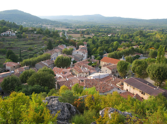
Rougiers (Rougiers)

- commune in Var, France
 Hiking in Rougiers
Rougiers is a small commune located in the Var department in the Provence-Alpes-Côte d'Azur region of southeastern France. It is surrounded by beautiful natural landscapes, making it an excellent spot for hiking enthusiasts. Here's a guide to hiking in the Rougiers area:
Scenic Trails
- Local Trails: The region features several marked trails that vary in difficulty, allowing both beginners and experienced hikers to enjoy the natural beauty of the area.
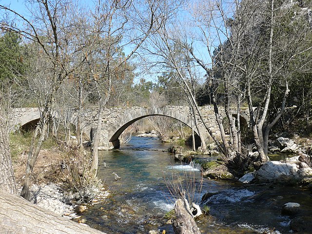
- Natural Features: Hikes around Rougiers often include views of vineyards, olive groves, and the iconic hills of Provence. You may also encounter diverse flora and fauna typical of the Mediterranean climate.
Points of Interest
- Vineyards and Wine Tasting: Many trails may lead you through local vineyards where you can stop and taste the regional wines.
- Historical Sites: The area has historical features, including old stone buildings and churches that provide insight into the local culture and history.
Tips for Hiking in Rougiers
- Preparation: Always wear appropriate footwear, and carry enough water and snacks, especially during the warmer months.
- Weather: Check the weather conditions ahead of your hike, as the region can get quite hot in summer.
- Maps and Guides: Consider obtaining maps or a guidebook that details the hiking trails in the Rougiers area for a better hiking experience.
Nearby Attractions
- Luberon Regional Park: If you're willing to travel a bit further, this area offers even more extensive hiking opportunities with stunning landscapes.
- Cultural Sites: Incorporate visits to nearby towns such as Signes or even the larger towns like Brignoles, where you can learn more about the local culture.
Overall, hiking in Rougiers offers a unique blend of natural beauty, culture, and local cuisine, making it a memorable experience for outdoor enthusiasts. Remember to respect the natural environment and follow local guidelines while hiking!
- Country:

- Postal Code: 83170
- Coordinates: 43° 23' 33" N, 5° 51' 4" E


- GPS tracks (wikiloc): [Link]
- Area: 20.53 sq km
- Population: 1623
- Wikipedia en: wiki(en)
- Wikipedia: wiki(fr)
- Wikidata storage: Wikidata: Q1364064
- Wikipedia Commons Category: [Link]
- Freebase ID: [/m/03qhfdl]
- GeoNames ID: Alt: [6454802]
- SIREN number: [218301109]
- BnF ID: [152779375]
- PACTOLS thesaurus ID: [pcrt4F4pTQW1z3]
- INSEE municipality code: 83110
Shares border with regions:

Mazaugues
- commune in Var, France
Hiking in Mazaugues
Mazaugues is a charming village located in the Var department of the Provence-Alpes-Côte d'Azur region in southeastern France. It is surrounded by beautiful landscapes, making it a great destination for hiking enthusiasts. Here are some highlights about hiking in and around Mazaugues:...
- Country:
- Postal Code: 83136
- Coordinates: 43° 20' 51" N, 5° 55' 19" E
- GPS tracks (wikiloc): [Link]
- Area: 53.79 sq km
- Population: 887


Nans-les-Pins
- commune in Var, France
Hiking in Nans-les-Pins
Nans-les-Pins is a charming village located in the Var department in the Provence-Alpes-Côte d'Azur region of France. It's surrounded by beautiful landscapes, making it a great destination for hiking enthusiasts. Here are some highlights of hiking in and around Nans-les-Pins:...
- Country:
- Postal Code: 83860
- Coordinates: 43° 22' 14" N, 5° 46' 56" E
- GPS tracks (wikiloc): [Link]
- Area: 47.99 sq km
- Population: 4276
- Web site: [Link]

Tourves
- commune in Var, France
Hiking in Tourves
Tourves is a charming commune located in the Var department of the Provence-Alpes-Côte d'Azur region in southeastern France. It is surrounded by stunning landscapes, including rolling hills, vineyards, and picturesque countryside, making it an ideal spot for hiking enthusiasts....
- Country:
- Postal Code: 83170
- Coordinates: 43° 24' 29" N, 5° 55' 26" E
- GPS tracks (wikiloc): [Link]
- Area: 65.62 sq km
- Population: 4973


Saint-Maximin-la-Sainte-Baume
- commune in Var, France
Hiking in Saint-Maximin-la-Sainte-Baume
Saint-Maximin-la-Sainte-Baume, located in the Provence-Alpes-Côte d'Azur region of France, is an excellent destination for hiking enthusiasts. The town is beautifully situated near the Sainte-Baume mountain range, which offers a variety of trails and stunning natural landscapes, making it ideal for all levels of hikers....
- Country:
- Postal Code: 83470
- Coordinates: 43° 27' 12" N, 5° 51' 43" E
- GPS tracks (wikiloc): [Link]
- Area: 64.13 sq km
- Population: 16037
- Web site: [Link]