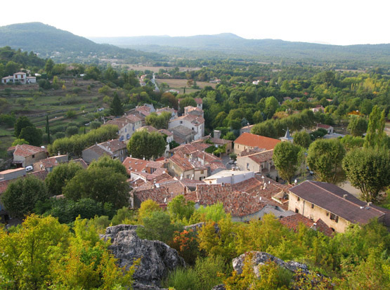
Tourves (Tourves)

- commune in Var, France
 Hiking in Tourves
Tourves is a charming commune located in the Var department of the Provence-Alpes-Côte d'Azur region in southeastern France. It is surrounded by stunning landscapes, including rolling hills, vineyards, and picturesque countryside, making it an ideal spot for hiking enthusiasts.
Hiking Trails
-
La Sainte-Baume Massif: This nearby mountain range offers several trails that lead you through lush forests, rocky outcrops, and panoramic viewpoints. The trails vary in difficulty, catering to both beginners and experienced hikers.
-
Les Gorges de la Douve: This is a wonderful area to explore a blend of natural beauty and geology. The gorges offer spectacular views and some intermediate hiking paths that allow you to enjoy the unique rock formations and the sound of flowing water.
-
Circuit des Templiers: This is a popular trail that takes you through historical sites, including old Templar structures and churches. The route is quite scenic and tends to be less crowded, providing a peaceful hiking experience.
-
Vineyard Walks: Tourves is also known for its vineyards. Consider a leisurely hike through the vineyards, which often have designated walking paths. You can combine hiking with wine tasting tours in some of the local wineries.
Tips for Hiking in Tourves
-
Best Time to Hike: The ideal seasons for hiking in Tourves are spring (April to June) and fall (September to November) when the weather is pleasant, and the scenery is particularly beautiful.
-
Preparation: Carry enough water, snacks, and a first aid kit. It’s essential to wear sturdy hiking shoes and dress in layers, as temperatures can fluctuate.
-
Maps and Navigation: Ensure you have a map or GPS device, as some trails can be less marked. Local tourism offices can provide useful hiking maps and information.
-
Respect Nature: Be sure to follow the "Leave No Trace" principles. Stay on designated paths and be respectful of local wildlife and plant life.
Hiking in Tourves allows you to experience the beauty of the Provence countryside while enjoying outdoor recreation. Don’t forget your camera, as the views are often breathtaking!
- Country:

- Postal Code: 83170
- Coordinates: 43° 24' 29" N, 5° 55' 26" E


- GPS tracks (wikiloc): [Link]
- Area: 65.62 sq km
- Population: 4973
- Wikipedia en: wiki(en)
- Wikipedia: wiki(fr)
- Wikidata storage: Wikidata: Q818280
- Wikipedia Commons Category: [Link]
- Freebase ID: [/m/03x_w_7]
- GeoNames ID: Alt: [2972168]
- SIREN number: [218301406]
- BnF ID: [152779673]
- VIAF ID: Alt: [240426310]
- GND ID: Alt: [4243308-3]
- PACTOLS thesaurus ID: [pcrtOZHKac4GFr]
- MusicBrainz area ID: [6f0dddff-fd89-46ff-8119-c8be8a49d9fc]
- INSEE municipality code: 83140
Shares border with regions:

Mazaugues
- commune in Var, France
Hiking in Mazaugues
Mazaugues is a charming village located in the Var department of the Provence-Alpes-Côte d'Azur region in southeastern France. It is surrounded by beautiful landscapes, making it a great destination for hiking enthusiasts. Here are some highlights about hiking in and around Mazaugues:...
- Country:
- Postal Code: 83136
- Coordinates: 43° 20' 51" N, 5° 55' 19" E
- GPS tracks (wikiloc): [Link]
- Area: 53.79 sq km
- Population: 887


Rougiers
- commune in Var, France
Hiking in Rougiers
Rougiers is a small commune located in the Var department in the Provence-Alpes-Côte d'Azur region of southeastern France. It is surrounded by beautiful natural landscapes, making it an excellent spot for hiking enthusiasts. Here's a guide to hiking in the Rougiers area:...
- Country:
- Postal Code: 83170
- Coordinates: 43° 23' 33" N, 5° 51' 4" E
- GPS tracks (wikiloc): [Link]
- Area: 20.53 sq km
- Population: 1623

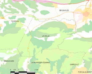
La Celle
- commune in Var, France
Hiking in La Celle
La Celle, a charming village nestled in the Var department of Provence-Alpes-Côte d'Azur, offers beautiful hiking opportunities amidst stunning natural scenery. The region is characterized by its picturesque landscapes, rolling hills, vineyards, and historical sites. Here are some highlights and tips for hiking in and around La Celle:...
- Country:
- Postal Code: 83170
- Coordinates: 43° 23' 39" N, 6° 2' 26" E
- GPS tracks (wikiloc): [Link]
- Area: 21 sq km
- Population: 1433


Brignoles
- commune in Var, France
Hiking in Brignoles
Brignoles, located in the Var department in southeastern France, is surrounded by beautiful landscapes that offer excellent opportunities for hiking and outdoor activities. Here are some highlights and tips for hiking around Brignoles:...
- Country:
- Postal Code: 83170
- Coordinates: 43° 24' 21" N, 6° 3' 42" E
- GPS tracks (wikiloc): [Link]
- Area: 70.53 sq km
- Population: 17093
- Web site: [Link]


Bras
- commune in Var, France
Hiking in Bras
Hiking in Bras, located in the Var department of the Provence-Alpes-Côte d'Azur region in southeastern France, offers a wonderful experience for nature lovers and outdoor enthusiasts. Here are some highlights and tips for hiking in this beautiful area:...
- Country:
- Postal Code: 83149
- Coordinates: 43° 28' 19" N, 5° 57' 13" E
- GPS tracks (wikiloc): [Link]
- Area: 34.93 sq km
- Population: 2675
- Web site: [Link]


Saint-Maximin-la-Sainte-Baume
- commune in Var, France
Hiking in Saint-Maximin-la-Sainte-Baume
Saint-Maximin-la-Sainte-Baume, located in the Provence-Alpes-Côte d'Azur region of France, is an excellent destination for hiking enthusiasts. The town is beautifully situated near the Sainte-Baume mountain range, which offers a variety of trails and stunning natural landscapes, making it ideal for all levels of hikers....
- Country:
- Postal Code: 83470
- Coordinates: 43° 27' 12" N, 5° 51' 43" E
- GPS tracks (wikiloc): [Link]
- Area: 64.13 sq km
- Population: 16037
- Web site: [Link]