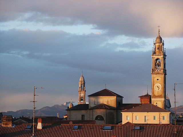
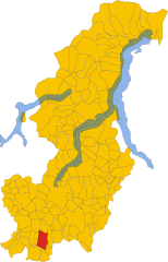
Rovello Porro (Rovello Porro)
.svg)
- Italian comune
 Hiking in Rovello Porro
Rovello Porro, located in the Lombardy region of Italy, is a charming town that offers a variety of outdoor activities, including hiking. While it may not be as widely recognized for hiking as some other locations in Italy, there are still great opportunities to explore the natural beauty of the surrounding area.
Hiking Trails
-
Local Nature Trails: There are several local paths and trails around Rovello Porro that allow you to experience the scenic countryside, which includes lush greenery, rolling hills, and wildlife. These trails can vary in difficulty and are great for both novice and experienced hikers.
-
Proximity to Larger Parks: Rovello Porro is close to some regional parks and natural reserves. The nearby Sasso di Malascarpa Natural Reserve offers hiking trails that lead through scenic landscapes, including forested areas and viewpoints.
-
Lakeside Hikes: Since the region is close to lakes like Lake Como and Lake Maggiore, you can also find trails that offer stunning views of the lakes, perfect for a relaxing day hike.
Tips for Hiking in Rovello Porro
- Best Time to Hike: Spring (April to June) and Fall (September to October) are ideal times for hiking in this region, with mild temperatures and beautiful landscapes.
- Safety: Always let someone know your hiking plans, and carry sufficient water, snacks, and a first aid kit.
- Local Guides: Consider hiring a local guide for a more informative experience about the flora, fauna, and history of the area.
- Respect Nature: Stick to marked trails and follow local guidelines to preserve the natural environment.
Cultural Aspects
In addition to hiking, you can explore some cultural sites in Rovello Porro, including historical buildings and local cuisine. Don’t forget to sample the local foods after your hike!
With a little exploration, you can find rewarding hiking experiences in and around Rovello Porro that showcase the beauty and charm of the Lombardy region.
- Country:

- Postal Code: 22070
- Local Dialing Code: 02
- Licence Plate Code: CO
- Coordinates: 45° 39' 0" N, 9° 2' 0" E


- GPS tracks (wikiloc): [Link]
- AboveSeaLevel: 240 м m
- Area: 5.53 sq km
- Population: 6122
- Web site: http://www.comune.rovelloporro.co.it
- Wikipedia en: wiki(en)
- Wikipedia: wiki(it)
- Wikidata storage: Wikidata: Q47408
- Wikipedia Commons Category: [Link]
- Freebase ID: [/m/0gj1nb]
- GeoNames ID: Alt: [6539466]
- VIAF ID: Alt: [249228786]
- OSM relation ID: [45613]
- GND ID: Alt: [7694334-3]
- WOEID: [722089]
- UN/LOCODE: [ITZBK]
- ISTAT ID: 013202
- Italian cadastre code: H602
Shares border with regions:
Cogliate
- Italian comune
Hiking in Cogliate
Cogliate is a charming area located in the Lombardy region of Italy, not far from the beautiful town of Monza and the vibrant city of Milan. While it may not be as famous as some other hiking destinations in Italy, it offers a variety of outdoor activities and natural beauty....
- Country:
- Postal Code: 20815
- Local Dialing Code: 02
- Licence Plate Code: MB
- Coordinates: 45° 38' 0" N, 9° 5' 0" E
- GPS tracks (wikiloc): [Link]
- AboveSeaLevel: 236 м m
- Area: 6.96 sq km
- Population: 8558
- Web site: [Link]
Misinto
- Italian comune
Hiking in Misinto
Misinto, a small town in the Lombardy region of Italy, is surrounded by picturesque landscapes that provide great opportunities for hiking. While it may not be as well-known as larger hiking destinations, you can still find some lovely trails and natural areas nearby. Here are some key points to consider if you're planning a hiking trip to Misinto:...
- Country:
- Postal Code: 20826
- Local Dialing Code: 02
- Licence Plate Code: MB
- Coordinates: 45° 40' 0" N, 9° 5' 0" E
- GPS tracks (wikiloc): [Link]
- AboveSeaLevel: 250 м m
- Area: 5.11 sq km
- Population: 5530
- Web site: [Link]


Gerenzano
- Italian comune
Hiking in Gerenzano
Gerenzano is a small town located in the Lombardy region of Italy, near Como and Milan. While it may not be widely known as a primary hiking destination, there are opportunities for outdoor enthusiasts in and around the area....
- Country:
- Postal Code: 21040
- Local Dialing Code: 02
- Licence Plate Code: VA
- Coordinates: 45° 38' 26" N, 9° 0' 7" E
- GPS tracks (wikiloc): [Link]
- AboveSeaLevel: 226 м m
- Area: 9.79 sq km
- Population: 10914
- Web site: [Link]


Saronno
- Italian comune
Hiking in Saronno
Saronno, located in the Lombardy region of northern Italy, is not primarily known as a hiking destination, but it does have access to some beautiful trails and natural areas nearby. Here are a few points to consider if you're looking to hike around Saronno:...
- Country:
- Postal Code: 21047
- Local Dialing Code: 02
- Licence Plate Code: VA
- Coordinates: 45° 37' 32" N, 9° 2' 13" E
- GPS tracks (wikiloc): [Link]
- AboveSeaLevel: 212 м m
- Area: 11.06 sq km
- Population: 39419
- Web site: [Link]
Turate
- Italian comune
Hiking in Turate
Turate, located in the Lombardy region of Italy, is primarily known as a residential town rather than a hiking destination. However, its location provides access to various hiking opportunities in the surrounding areas....
- Country:
- Postal Code: 22078
- Local Dialing Code: 02
- Licence Plate Code: CO
- Coordinates: 45° 39' 30" N, 9° 0' 0" E
- GPS tracks (wikiloc): [Link]
- AboveSeaLevel: 240 м m
- Area: 10.28 sq km
- Population: 9506
- Web site: [Link]


Rovellasca
- Italian comune
Hiking in Rovellasca
Rovellasca is a small town located in the Lombardy region of Italy, near Lake Como and not far from Milan. While it may not be as well-known for hiking as some of its neighboring areas, there are plenty of opportunities for outdoor activities and scenic walks in the surrounding region....
- Country:
- Postal Code: 22069
- Local Dialing Code: 02
- Licence Plate Code: CO
- Coordinates: 45° 40' 0" N, 9° 3' 0" E
- GPS tracks (wikiloc): [Link]
- AboveSeaLevel: 244 м m
- Area: 3.57 sq km
- Population: 7797
- Web site: [Link]
Lomazzo
- Italian comune
Hiking in Lomazzo
Lomazzo, a charming town located in the Lombardy region of Italy, offers a variety of hiking opportunities, particularly due to its proximity to the beautiful natural landscapes of the surrounding area, including the nearby Alps and the foothills of the Prealps....
- Country:
- Postal Code: 22074
- Local Dialing Code: 02
- Licence Plate Code: CO
- Coordinates: 45° 42' 0" N, 9° 2' 0" E
- GPS tracks (wikiloc): [Link]
- AboveSeaLevel: 296 м m
- Area: 9.48 sq km
- Population: 9929
- Web site: [Link]