Sénergues (Sénergues)

- commune in Aveyron, France
- Country:

- Postal Code: 12320
- Coordinates: 44° 36' 21" N, 2° 29' 5" E


- GPS tracks (wikiloc): [Link]
- Area: 44.9 sq km
- Population: 421
- Web site: http://www.senergues.fr
- Wikipedia en: wiki(en)
- Wikipedia: wiki(fr)
- Wikidata storage: Wikidata: Q177835
- Wikipedia Commons Gallery: [Link]
- Wikipedia Commons Category: [Link]
- Freebase ID: [/m/03m95yw]
- GeoNames ID: Alt: [6427056]
- SIREN number: [211202684]
- VIAF ID: Alt: [127002951]
- Library of Congress authority ID: Alt: [no2002014575]
- INSEE municipality code: 12268
Shares border with regions:

Le Fel
- commune in Aveyron, France
- Country:
- Postal Code: 12140
- Coordinates: 44° 39' 12" N, 2° 30' 19" E
- GPS tracks (wikiloc): [Link]
- AboveSeaLevel: 320 м m
- Area: 24.89 sq km
- Population: 169
- Web site: [Link]


Saint-Félix-de-Lunel
- commune in Aveyron, France
- Country:
- Postal Code: 12320
- Coordinates: 44° 33' 43" N, 2° 32' 20" E
- GPS tracks (wikiloc): [Link]
- Area: 18.98 sq km
- Population: 377

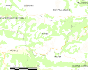
Pruines
- commune in Aveyron, France
- Country:
- Postal Code: 12320
- Coordinates: 44° 31' 50" N, 2° 30' 12" E
- GPS tracks (wikiloc): [Link]
- Area: 18.88 sq km
- Population: 308


Vieillevie
- commune in Cantal, France
- Country:
- Postal Code: 15120
- Coordinates: 44° 38' 42" N, 2° 25' 3" E
- GPS tracks (wikiloc): [Link]
- Area: 9.65 sq km
- Population: 111


Espeyrac
- commune in Aveyron, France
- Country:
- Postal Code: 12140
- Coordinates: 44° 36' 47" N, 2° 30' 37" E
- GPS tracks (wikiloc): [Link]
- Area: 22.28 sq km
- Population: 237
- Web site: [Link]