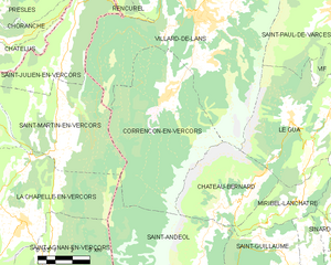
Saint-Andéol (Saint-Andéol)
- commune in Isère, France
Saint-Andéol, located in the Isère department in the Auvergne-Rhône-Alpes region of France, is a wonderful destination for hiking enthusiasts. The area is characterized by its stunning natural landscapes, including picturesque valleys, forests, and views of the surrounding mountains.
Hiking Trails:
- Variety of Trails: The region around Saint-Andéol offers a range of trails suitable for various skill levels, from easy walks to more challenging hikes. Whether you are a beginner or an experienced hiker, you can find a trail that suits your abilities.
- Nature Reserves: Nearby nature reserves provide well-maintained paths and the chance to spot local wildlife, such as birds, deer, and more.
Popular Hikes:
- Monts du Lyonnais: You can explore the trails leading up to the Monts du Lyonnais, where you’re rewarded with panoramic views of the countryside.
- Climbing Routes: If you're interested in climbing, the cliffs around Saint-Andéol offer various climbing routes.
Tips for Hiking in Saint-Andéol:
- Weather Considerations: Check the weather forecast before heading out, as conditions can change rapidly in mountainous regions.
- Local Maps: Obtain a hiking map or guide at local tourist offices to ensure that you have the most up-to-date information about trails and conditions.
- Gear up Properly: Wear sturdy hiking boots, bring enough water, snacks, and a first aid kit. It's also advisable to inform someone about your hiking plan.
Best Time to Visit:
- Spring and Fall: These seasons are particularly beautiful for hiking, with mild temperatures and fewer crowds. Wildflowers bloom in the spring, while foliage turns vibrant in the fall.
Local Culture and Amenities:
- Accommodations: Saint-Andéol has local accommodations, including guesthouses and campsites, to help you rest after a long day of hiking.
- Culinary Delights: Don’t miss the opportunity to enjoy regional cuisine in local restaurants, which often feature traditional French dishes and local specialties.
Whether you’re looking for a peaceful day on the trail or an adventurous hiking experience, Saint-Andéol in Isère offers a charming backdrop for all your hiking endeavors. Enjoy your adventure!
- Country:

- Postal Code: 38650
- Coordinates: 44° 57' 40" N, 5° 33' 9" E


- GPS tracks (wikiloc): [Link]
- Area: 29.7 sq km
- Population: 125
- Wikipedia en: wiki(en)
- Wikipedia: wiki(fr)
- Wikidata storage: Wikidata: Q1364396
- Wikipedia Commons Category: [Link]
- Freebase ID: [/m/03g_5z4]
- SIREN number: [213803554]
- BnF ID: [15258166c]
- INSEE municipality code: 38355
Shares border with regions:


Corrençon-en-Vercors
- commune in Isère, France
 Hiking in Corrençon-en-Vercors
Corrençon-en-Vercors is a charming alpine village located in the Vercors Regional Natural Park in the French Alps. It offers a variety of hiking opportunities that cater to different skill levels and preferences. Here are some highlights and tips for hiking in and around Corrençon-en-Vercors:...
- Country:

- Postal Code: 38250
- Coordinates: 45° 1' 53" N, 5° 31' 35" E


- GPS tracks (wikiloc): [Link]
- Area: 39.34 sq km
- Population: 353
- Web site: [Link]


Saint-Guillaume
- commune in Isère, France
Saint-Guillaume, located in Quebec, Canada, offers a variety of hiking opportunities amidst beautiful natural landscapes. The area is characterized by its lush forests, rolling hills, and scenic views, making it an appealing destination for both novice and experienced hikers....
- Country:

- Postal Code: 38650
- Coordinates: 44° 57' 18" N, 5° 35' 21" E


- GPS tracks (wikiloc): [Link]
- Area: 13.33 sq km
- Population: 265


Gresse-en-Vercors
- commune in Isère, France
Gresse-en-Vercors is a charming village located in the Vercors Regional Natural Park in the French Alps. It’s an exceptional area for hiking, offering a variety of trails that cater to a range of skill levels, from beginners to experienced hikers. Here are some highlights and things to consider when hiking in Gresse-en-Vercors:...
- Country:

- Postal Code: 38650
- Coordinates: 44° 54' 8" N, 5° 34' 0" E


- GPS tracks (wikiloc): [Link]
- Area: 81.13 sq km
- Population: 395
- Web site: [Link]


Château-Bernard
- commune in Isère, France
Hiking in Château-Bernard offers a delightful opportunity to explore the natural beauty of the area, characterized by picturesque landscapes, diverse flora and fauna, and a rich cultural history. While Château-Bernard itself is a small commune in the Auvergne region of France, there are several hikes and trails in the surrounding areas that cater to various skill levels....
- Country:

- Postal Code: 38650
- Coordinates: 44° 58' 30" N, 5° 34' 35" E


- GPS tracks (wikiloc): [Link]
- Area: 18.27 sq km
- Population: 276
- Web site: [Link]
Saint-Agnan-en-Vercors
- commune in Drôme, France
 Hiking in Saint-Agnan-en-Vercors
Saint-Agnan-en-Vercors is a charming village located in the Vercors Massif, part of the French Pre-Alps. This area is known for its stunning landscapes, rich biodiversity, and extensive network of hiking trails, making it a fantastic destination for both novice and experienced hikers....
- Country:

- Postal Code: 26420
- Coordinates: 44° 56' 8" N, 5° 25' 52" E


- GPS tracks (wikiloc): [Link]
- Area: 84.21 sq km
- Population: 397


La Chapelle-en-Vercors
- commune in Drôme, France
 Hiking in La Chapelle-en-Vercors
La Chapelle-en-Vercors is a beautiful village located in the Vercors Regional Natural Park in the Auvergne-Rhône-Alpes region of France. This area is renowned for its stunning landscapes, diverse flora and fauna, and a variety of hiking trails suitable for different skill levels. Here’s what you can expect from hiking in this area:...
- Country:

- Postal Code: 26420
- Coordinates: 44° 58' 4" N, 5° 24' 59" E


- GPS tracks (wikiloc): [Link]
- Area: 45.27 sq km
- Population: 685
