Saint-Agnan-en-Vercors (Saint-Agnan-en-Vercors)

- commune in Drôme, France
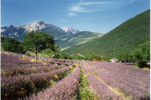
 Hiking in Saint-Agnan-en-Vercors
Saint-Agnan-en-Vercors is a charming village located in the Vercors Massif, part of the French Pre-Alps. This area is known for its stunning landscapes, rich biodiversity, and extensive network of hiking trails, making it a fantastic destination for both novice and experienced hikers.
Hiking Trails
-
Les Platières: This moderate trail offers breathtaking panoramic views of the surrounding mountains and valleys. It’s perfect for those looking to experience the beauty of the Vercors with various points to rest and take in the scenery.
-
Le Pas de la Vache: A more challenging hike that leads you through diverse terrain, including forests and rocky outcrops. This trail will offer a sense of adventure and the chance to see local wildlife.
-
Lac de la Doux: A beautiful hiking route that takes you to the serene Lac de la Doux. The trail is relatively easy, making it accessible for families. The lake is ideal for a picnic stop, so consider bringing lunch to enjoy by the water.
-
Les Caves de la Drôme: A unique hiking experience that combines nature walks with an exploration of impressive cave systems. Guided tours are sometimes available, giving hikers a chance to learn about the geology and natural history of the region.
Nature and Wildlife
The Vercors region is known for its diverse ecosystems, home to various wildlife species. Keep an eye out for chamois, deer, and numerous bird species as you hike. The area is also rich in flora, with many endemic plants and flowers.
Best Time to Hike
The best time for hiking in Saint-Agnan-en-Vercors is typically late spring to early fall (May to September), when the weather is mild and the trails are usually accessible. Summer can be busy, so early mornings or late afternoons are preferred for a quieter experience.
Preparation Tips
- Footwear: Make sure to wear sturdy hiking boots to navigate the rocky and sometimes uneven terrain.
- Weather: Be prepared for changing weather conditions, especially in the mountains. Bring layers and rain gear.
- Hydration and Snacks: Carry sufficient water and snacks to keep your energy levels up during your hikes.
- Maps and Information: It’s wise to obtain a local hiking map or guide to ensure you stay on marked trails and stay informed about the area.
Overall, Saint-Agnan-en-Vercors is a wonderful place for hiking enthusiasts, offering a mix of scenic beauty, tranquility, and adventure. Enjoy exploring this magnificent part of France!
- Country:

- Postal Code: 26420
- Coordinates: 44° 56' 8" N, 5° 25' 52" E


- GPS tracks (wikiloc): [Link]
- Area: 84.21 sq km
- Population: 397
- Wikipedia en: wiki(en)
- Wikipedia: wiki(fr)
- Wikidata storage: Wikidata: Q744995
- Wikipedia Commons Category: [Link]
- Freebase ID: [/m/03mhjvk]
- GeoNames ID: Alt: [6430202]
- SIREN number: [212602908]
- BnF ID: [15253150s]
- VIAF ID: Alt: [159482457]
- PACTOLS thesaurus ID: [pcrtOvLF644qxc]
- SUDOC authorities ID: [050374389]
- INSEE municipality code: 26290
Shares border with regions:


Romeyer
- commune in Drôme, France
Hiking in Romeyer
Romeyer is a beautiful area in the French Alps, often praised for its stunning natural beauty, diverse landscapes, and excellent hiking opportunities. While it may not be as widely known as some other hiking destinations in France, it offers a great experience for those looking to explore the outdoors....
- Country:
- Postal Code: 26150
- Coordinates: 44° 46' 46" N, 5° 24' 32" E
- GPS tracks (wikiloc): [Link]
- Area: 41.46 sq km
- Population: 203


Gresse-en-Vercors
- commune in Isère, France
Hiking in Gresse-en-Vercors
Gresse-en-Vercors is a charming village located in the Vercors Regional Natural Park in the French Alps. It’s an exceptional area for hiking, offering a variety of trails that cater to a range of skill levels, from beginners to experienced hikers. Here are some highlights and things to consider when hiking in Gresse-en-Vercors:...
- Country:
- Postal Code: 38650
- Coordinates: 44° 54' 8" N, 5° 34' 0" E
- GPS tracks (wikiloc): [Link]
- Area: 81.13 sq km
- Population: 395
- Web site: [Link]


Saint-Andéol
- commune in Isère, France
Hiking in Saint-Andéol
Saint-Andéol, located in the Isère department in the Auvergne-Rhône-Alpes region of France, is a wonderful destination for hiking enthusiasts. The area is characterized by its stunning natural landscapes, including picturesque valleys, forests, and views of the surrounding mountains....
- Country:
- Postal Code: 38650
- Coordinates: 44° 57' 40" N, 5° 33' 9" E
- GPS tracks (wikiloc): [Link]
- Area: 29.7 sq km
- Population: 125


Vassieux-en-Vercors
- commune in Drôme, France
Hiking in Vassieux-en-Vercors
Vassieux-en-Vercors is a beautiful village located in the Vercors Regional Natural Park in France, known for its stunning natural landscapes and outdoor activities, especially hiking. The area is characterized by its dramatic limestone cliffs, dense forests, and rich biodiversity, making it an ideal destination for hikers of all levels....
- Country:
- Postal Code: 26420
- Coordinates: 44° 53' 43" N, 5° 22' 13" E
- GPS tracks (wikiloc): [Link]
- Area: 48.25 sq km
- Population: 318
- Web site: [Link]

Chamaloc
- commune in Drôme, France
Hiking in Chamaloc
Chamaloc, located in the Île-de-France region of France, is a lesser-known destination for hiking enthusiasts. While it may not be as famous as other hiking hotspots in France, it offers beautifully scenic trails and a peaceful escape into nature. Here’s what you need to know about hiking in and around Chamaloc:...
- Country:
- Postal Code: 26150
- Coordinates: 44° 47' 55" N, 5° 23' 2" E
- GPS tracks (wikiloc): [Link]
- Area: 21.89 sq km
- Population: 129


La Chapelle-en-Vercors
- commune in Drôme, France
Hiking in La Chapelle-en-Vercors
La Chapelle-en-Vercors is a beautiful village located in the Vercors Regional Natural Park in the Auvergne-Rhône-Alpes region of France. This area is renowned for its stunning landscapes, diverse flora and fauna, and a variety of hiking trails suitable for different skill levels. Here’s what you can expect from hiking in this area:...
- Country:
- Postal Code: 26420
- Coordinates: 44° 58' 4" N, 5° 24' 59" E
- GPS tracks (wikiloc): [Link]
- Area: 45.27 sq km
- Population: 685