Château-Bernard (Château-Bernard)

- commune in Isère, France
 Hiking in Château-Bernard
Hiking in Château-Bernard offers a delightful opportunity to explore the natural beauty of the area, characterized by picturesque landscapes, diverse flora and fauna, and a rich cultural history. While Château-Bernard itself is a small commune in the Auvergne region of France, there are several hikes and trails in the surrounding areas that cater to various skill levels.
Here are a few highlights to consider:
-
Beautiful Scenery: The region features rolling hills, lush forests, and stunning views of the surrounding countryside. Hikers can enjoy peaceful landscapes that change with the seasons.
-
Trail Networks: While there might not be specific trails directly in Château-Bernard, the Auvergne region has an extensive network of trails. Nearby, you can find paths leading through the Parc Naturel Régional des Volcans d'Auvergne, which offers extensive hiking opportunities with marked routes.
-
Wildlife Watching: As you hike, keep an eye out for local wildlife. The area is home to a variety of animals, including deer, birds, and small mammals.
-
Historical Sites: Hiking can be combined with visits to nearby historical sites, churches, and castles that reflect the rich history of the region.
-
Accessibility: Make sure to check the accessibility of trails before heading out, as some paths may be challenging. Depending on your experience level, choose hikes that match your ability.
-
Local Advice: It’s always a good idea to visit a local tourist office for maps, trail information, and advice on the best hiking routes in the area.
Whether you're looking for a leisurely stroll or a challenging trek, hiking near Château-Bernard can be a fulfilling way to connect with nature and enjoy the charm of rural France. Always remember to carry enough water, snacks, wear appropriate footwear, and obey local guidelines while hiking.
- Country:

- Postal Code: 38650
- Coordinates: 44° 58' 30" N, 5° 34' 35" E


- GPS tracks (wikiloc): [Link]
- Area: 18.27 sq km
- Population: 276
- Web site: http://www.col-de-larzelier.fr
- Wikipedia en: wiki(en)
- Wikipedia: wiki(fr)
- Wikidata storage: Wikidata: Q573835
- Wikipedia Commons Category: [Link]
- Freebase ID: [/m/03nvgnb]
- GeoNames ID: Alt: [6448755]
- SIREN number: [213800907]
- BnF ID: [152579174]
- INSEE municipality code: 38090
Shares border with regions:

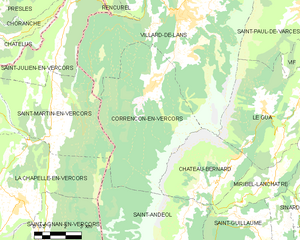
Corrençon-en-Vercors
- commune in Isère, France
Hiking in Corrençon-en-Vercors
Corrençon-en-Vercors is a charming alpine village located in the Vercors Regional Natural Park in the French Alps. It offers a variety of hiking opportunities that cater to different skill levels and preferences. Here are some highlights and tips for hiking in and around Corrençon-en-Vercors:...
- Country:
- Postal Code: 38250
- Coordinates: 45° 1' 53" N, 5° 31' 35" E
- GPS tracks (wikiloc): [Link]
- Area: 39.34 sq km
- Population: 353
- Web site: [Link]


Le Gua
- commune in Isère, France
Hiking in Le Gua
Le Gua, located in the Isère department of the Auvergne-Rhône-Alpes region in France, offers a blend of picturesque landscapes and accessible hiking trails, making it a great destination for outdoor enthusiasts. Here are some highlights and tips for hiking in Le Gua:...
- Country:
- Postal Code: 38450
- Coordinates: 45° 1' 31" N, 5° 38' 52" E
- GPS tracks (wikiloc): [Link]
- Area: 28.48 sq km
- Population: 1812
- Web site: [Link]


Miribel-Lanchâtre
- commune in Isère, France
Hiking in Miribel-Lanchâtre
Miribel-Lanchâtre is a charming destination in the department of Isère, in the Auvergne-Rhône-Alpes region of France. It offers beautiful landscapes, rich biodiversity, and various hiking opportunities that cater to different skill levels, making it an excellent spot for hiking enthusiasts....
- Country:
- Postal Code: 38450
- Coordinates: 44° 58' 28" N, 5° 37' 13" E
- GPS tracks (wikiloc): [Link]
- Area: 9.65 sq km
- Population: 415
- Web site: [Link]


Saint-Andéol
- commune in Isère, France
Hiking in Saint-Andéol
Saint-Andéol, located in the Isère department in the Auvergne-Rhône-Alpes region of France, is a wonderful destination for hiking enthusiasts. The area is characterized by its stunning natural landscapes, including picturesque valleys, forests, and views of the surrounding mountains....
- Country:
- Postal Code: 38650
- Coordinates: 44° 57' 40" N, 5° 33' 9" E
- GPS tracks (wikiloc): [Link]
- Area: 29.7 sq km
- Population: 125


Villard-de-Lans
- commune in Isère, France
Hiking in Villard-de-Lans
Villard-de-Lans is a charming village located in the Vercors region of the French Alps, known for its stunning landscapes, diverse trails, and outdoor activities, making it a fantastic destination for hiking enthusiasts. Here are some key points about hiking in Villard-de-Lans:...
- Country:
- Postal Code: 38250
- Coordinates: 45° 4' 12" N, 5° 33' 2" E
- GPS tracks (wikiloc): [Link]
- Area: 67.2 sq km
- Population: 4175
- Web site: [Link]